Title
Kintang Channel.
1849 (dated)
20 x 27 in (50.8 x 68.58 cm)
1 : 54000
Description
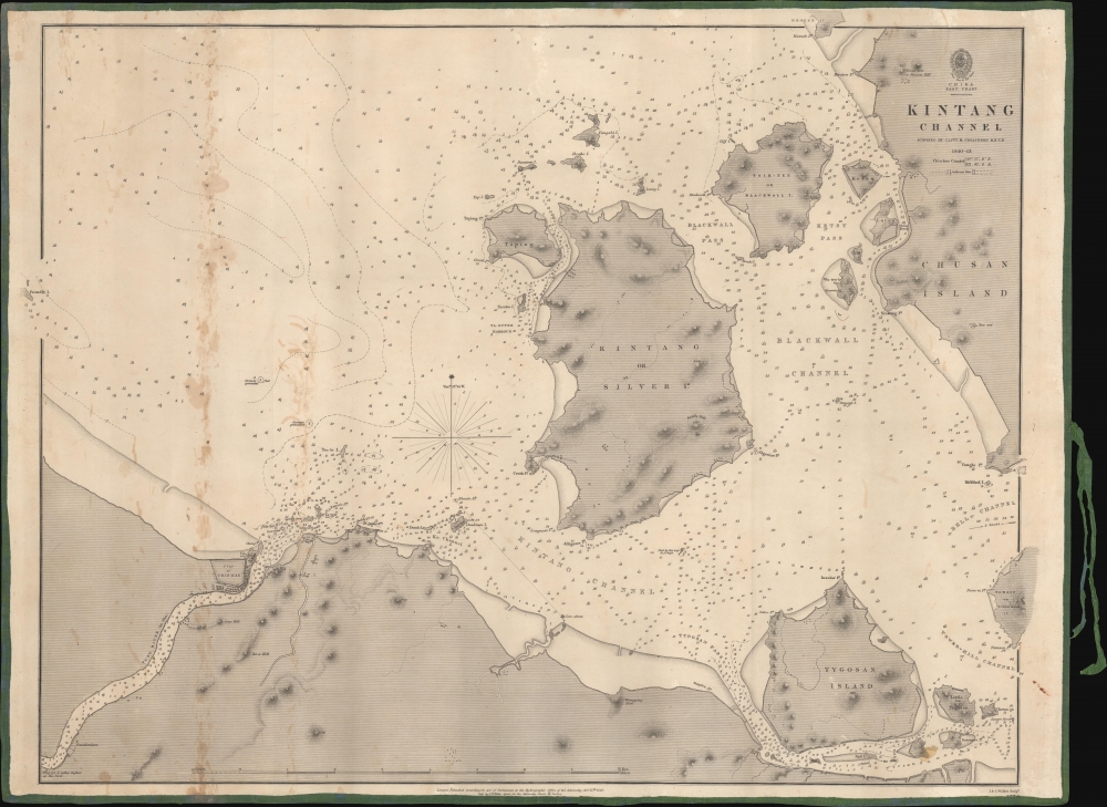
A remarkable 1849 first edition example of Richard Collinson's important blueback nautical chart or map of the coasts off Ningbo (Ning-po), between the Chinese mainland and Zhoushan (Chusan). These waters had long been important for China's interactions with the outside world and formed a strategic point of control during the First Opium War (1839 - 1842).
A Closer Look
Kintang (Jintang 金塘) Channel, referred to in the title, lies between Zhoushan and Ningbo in Zhejiang Province, some 80 miles south of Shanghai. This area was of critical importance during the First Opium War, which Collinson fought in, including in these waters.
Navigational information appears throughout, including extremely detailed soundings, labeling of passes and channels, islands, islets, shoals, hazards, and currents. Points where British ships grounded in the shallow coastal waters are noted. Landward features including settlements and promontories are also indicated. A compass rose with magnetic variations appears near center.
The coastal city of Chin-hae (Zhenhai, 镇海), now a district of Ningbo, was the site of a swift, decisive British victory during the First Opium War. The citadel seen here sat atop a hill and guarded the entrance to the Yong River (甬江, here as Yung River), leading to Ningbo. The British captured the fort on October 10, 1841 (dismantling it afterwards), allowing them to capture Ningbo unopposed three days later. Just beyond the scope of the chart, further east along the southern coast of Zhoushan, is Dinghai (定海), site of two battles during the First Opium War.Zhoushan - China's Door to the Maritime World
The archipelago that today forms Zhoushan Municipality has a recorded history stretching well into Antiquity. The proximity of the islands to the mainland, and particularly to the city of Ningbo (just to the west of the area shown here), made them an ideal location for fisherfolk, traders, rebels, and pirates. Its location, jutting out into the East China Sea, has historically made it a destination for foreign travelers of many stripes, including the 9th century Japanese Buddhist monk Egaku (慧锷), who founded a now-famous Buddhist pilgrimage site at Putuoshan (普陀山).
In the Ming Dynasty, when a maritime ban was in place to dissuade widespread piracy and coastal raiding, Zhoushan was an important entrepot for trade between Chinese, Japanese, Southeast Asian, and Portuguese traders. At the end of the 17th century, the newly triumphant Qing Dynasty ended the maritime bans and trade was encouraged at certain ports, including Zhoushan (more specifically, Dinghai). English traders, among others, stopped at Zhoushan and gained some familiarity with the local geography, producing the earliest European charts of the area. But the establishment of the Canton System of Trade in the mid-18th century confined Western traders to Canton (Guangzhou).
European traders had not forgotten Zhoushan, though, and it was a request of the failed British Macartney Mission of 1793 to have an island there reserved for British traders. When the First Opium War broke out, the British quickly moved to capture Zhoushan, which was then returned to China in exchange for Hong Kong, before being recaptured by the British later in the war (the Foreign Secretary Lord Palmerston considered Hong Kong to be of much lesser value than Zhoushan). With the rise of the treaty ports (including nearby Ningbo) and Hong Kong, Zhoushan's significance as a door to the outside world diminished.Collinson's Charts
Following the acquisition of Hong Kong at the end of the First Opium War (1839 - 1842), the British recognized the demand for detailed surveys of the China Coast. They turned to Richard Collinson, a Royal Navy officer who had distinguished himself in the war, including a stint commanding the famed Nemesis, Britain's first ocean-going iron warship, around Zhoushan. Collinson completed detailed surveys of the China coast in the vicinity of Hong Kong between 1842 and 1846. His familiarity with these coasts and the long duration of the surveys resulted in charts that were renowned for their detail and precision. They were employed for decades afterwards for both military and commercial purposes and were a significant influence on later charts of the China coast.Blueback Charts
Blueback nautical charts began appearing in London in the late 18th century. Bluebacks, as they came to be called, were privately published large format nautical charts known for their distinctive blue paper backing. The backing, a commonly available blue manila paper traditionally used by publishers to wrap unbound pamphlets, was adopted as a practical way to reinforce the low-quality paper used by private chart publishers in an effort to cut costs. That being said, not all blueback charts are literally backed with blue paper. The earliest known blueback charts include a 1760 chart issued by Mount and Page, and a 1787 chart issued by Robert Sayer.
The tradition took off in the early 19th century, when British publishers like John Hamilton Moore, Robert Blachford, James Imray, William Heather, John William Norie, Charles Wilson, David Steel, R. H. Laurie, and John Hobbs, among others, rose to dominate the chart trade. Bluebacks became so popular that the convention was embraced by chartmakers outside of England, including Americans Edmund March Blunt and George Eldridge, as well as Scandinavian, French, German, Russian, and Spanish chartmakers. Blueback charts remained popular until the late 19th century, when government subsidized organizations like the British Admiralty Hydrographic Office and the United States Coast Survey began issuing their own superior charts on high quality paper that did not require reinforcement.Publication History and Census
This chart was based on surveys conducted by Collinson during and soon after the Opium War, between 1840 and 1843, but was not published until 1849, making this a first edition. It was engraved by J. and C. Walker, who engraved most of Collinson's charts, among others, for the British Admiralty. A subsequent edition was published in 1865. In either case, the map is quite rare, and in either edition is only listed among the holdings of the British Library.
CartographerS
Richard Collinson (November 7, 1811 – September 13, 1883) was an English naval officer, marine surveyor, and Arctic explorer. He was born in Gateshead, Tyne and Wear, England, then part of Durham. He joined the Royal Navy in 1823, at age twelve, and rose in the ranks, becoming a lieutenant in 1835, commander in 1841, and captain in 1842. Collinson was a highly capable captain. He participated with distinction in the First Opium War (1839 - 1842). After the war, along with Commander Henry Kellett, he completed a series of pioneering surveys of the China coast from the Yangtze River to Hong Kong. These he completed between 1842 and 1846 while serving as commander of the HMS Plover. In 1850, he was sent north in command of the HMS Enterprise to search for survivors of the Sir John Franklin expedition. Although he came quite close, he never found Franklin's lost men and returned to England without success. Nonetheless, he was honored by the Royal Geographical Society for his surveys in the Arctic and proof that it was navigable from the Behring Strait to King William's Land. Collinson was Knighted in 1875, the same year in which he retired from active duty with the rand of Admiral. Collinson died in September of 1883. More by this mapmaker...
The British Admiralty Office (1795 - Present) or the United Kingdom Hydrographic Office refers to the Branch of the English government that is responsible for the command of the British Navy. In 1795 King George III created the United Kingdom Hydrographic Office, known in short as the U.K.H.O., to provide top notch nautical charts to the vast Royal Navy. Prior the founding of the Admiralty the surveying and creation of nautical charts was primarily a commercial venture wherein the cartographer himself, more of than not, actually financed the printing of his own material. The great navigator Cook himself is known to have scrambled for funds to publish his own seminal charts - the most important and advanced of the period. The system of privately funded nautical mapping and publishing left vast portions of the world uncharted and many excellent charts unpublished. King George III, responding significant loss in trade revenue related to shipwrecks and delay due to poor charts, recognized the need for an institutionalized government sponsored cartographic agency - the Admiralty. The first head of the Admiralty, a position known as Hydrographer, was the important cartographer Alexander Dalrymple. Dalrymple started by organizing and cataloging obtainable charts before initiating the laborious process of updating them and filling in the blanks. The first official Admiralty Chart appeared in 1800 and detailed Quiberon Bay in Brittany. By 1808 the position of Hydrographer fell to Captain Thomas Hurd. Hurd advocated the sale of Admiralty charts to the general public and, by the time he retired in 1829, had issued and published some 736 charts. Stewardship of the organization then passed to Rear Admiral Sir Francis Beaufort. It was under Beaufort's administration that the Admiralty truly developed as a "chart making" as opposed to a "chart cataloging" institution. Beaufort held his post from 1829 to 1854. In his 25 years at the Admiralty Beaufort created nearly 1500 new charts and sponsored countless surveying and scientific expeditions - including the 1831 to 1836 voyage of the H.M.S. Beagle. By 1855 the Admiralty's chart catalog listed some 1,981 charts. Learn More...
John Walker (1787 - April 19, 1873) was a British map seller, engraver, lithographer, hydrographer, geographer, draughtsman, and publisher active in London during the 19th century. Walker published both nautical charts and geographical maps. His nautical work is particularly distinguished as he was an official hydrographer for the British East India Company, a position, incidentally, also held by his father of the same name. Walker's maps, mostly published after 1827, were primarily produced with his brothers Charles Walker and Alexander Walker under the imprint J. and C. Walker. Among their joint projects are more than 200 maps for the influential Society for the Diffusion of Useful Knowledge Atlas (SDUK). In addition they published numerous charts for James Horsburgh and the British Admiralty Hydrographic Office, including Belcher's important map of Hong Kong and Carless' exploratory map of Karachi. The J. and C. Walker firm continued to publish after both Walkers died in the 1870s. Learn More...
Condition
Very good. Some discoloration along the vertical, left quadrants. Original backing, green edging, and ties.
References
OCLC 557876418.