1931 Admiralty Nautical Chart of the Approaches to the Yangtze River, China
YangtzeApproaches-admiralty-1931$1,000.00


Title
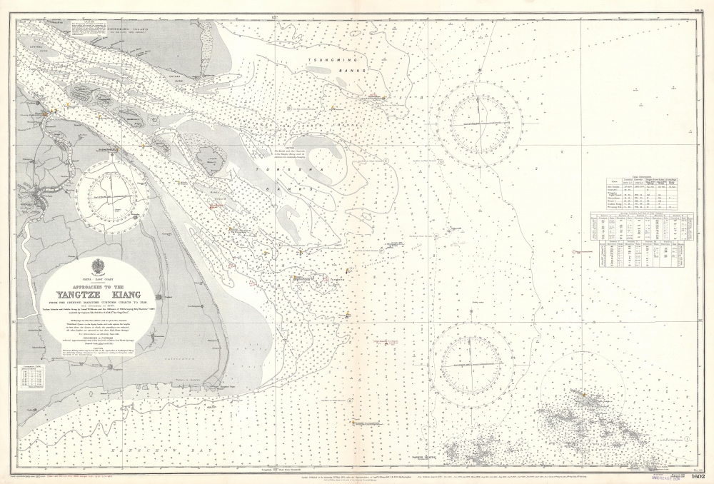
Approaches to the Yangtze Kiang. From the Chinese Maritime Customs Charts to 1928.
1931 (dated) 27 x 39.5 in (68.58 x 100.33 cm) 1 : 145510
1931 (dated) 27 x 39.5 in (68.58 x 100.33 cm) 1 : 145510
Description
This is a 1931 British Admiralty nautical map of the approaches to the Yangtze River, in the vicinity of Shanghai, China. The map captures Shanghai at the end of the 1920s, a kind of golden age when Shanghai emerged as the largest and most cosmopolitan city in China. Within a year of this chart's issue, the 1932 Shanghai Incident began a decade of chaos culminating in the Second Sino-Japanese War (1937 -1845).
A Closer Look
The chart depicts from Shanghai to the China Sea and from Tsungming (Chongming) Island to Hangchow (Hangzhou) Bay, the Parker Islands, and the Saddle Group. The chart is highly detailed with dense depth soundings (fathoms) throughout. Coastal locations, islands, banks, and channels are identified. Shanghai is situated along the left border, with some locations, including the British consulate, labeled.Manuscript Notations
Numerous manuscript notations have been added in red ink. These have been recorded, also in manuscript, in the lower left corner with dates from 1932 - 1935. One of these notations is a new light. A handful of pencil notations are present as well.Shanghai 1910 - 1932
The 1910s-20s were a golden age for Shanghai, at least in the Concessions. While China was ruled by Chiang Kai-shek, Shanghai was dominated by several consolidated foreign trade Concessions. Under the strict administrative control of the Concessions, the city became a cosmopolitan haven in the midst of political unrest and a center for global trade and finance. The Concessions occupied what is today central Shanghai's most desirable land, hugging the Huangpu River and Wusong River (Suzhou Creek). These extraterritorial European, Japanese, and American enclaves had modern housing, fine roads, streetcars, elegant shops, clubs, and more. It was a place of excess, art, and extravagance, where fortunes could be made by the enterprising - and lost by the foolish. Moreover, lacking the moral constraints that limited social life in Europe and America, Shanghai became nexus for the opium trade, sexual excess, gambling, and other vices. This ephemeral world come crashing down on January 28, 1932, when the 'Shanghai Incident' or 'January 28 Incident' pitted the Republic of China against the Empire of Japan. Responding to Chinese student protests against the Japanese occupation of Manchuria, the Japanese Navy bombarded Shanghai.Shanghai Incident of 1932
The conflict of January 28th, 1932, also known as the Shanghai Incident or Shanghai War, was a precursor to the Second Sino-Japanese War (1937 -1845), which would begin a few years later. Following several alleged attacks on Japanese nationals, the Japanese launched a Blitzkrieg-style attack on Chinese Nationalist forces with the supposed intent of protecting Japanese civilians residing in the Hongkou District, an informal Japanese Concession within the International Settlement. The Chinese Nationalist troops concentrated in Zhabei in order to protect the strategically important Shanghai Railway Station, through which supplies and reinforcements could be readily delivered. The Chinese resistance proved stubborn and both sides established perimeters along the Huangpu River. A similar perimeter was stabled to the south, along the Wusong River, to protect the British and French Concessions. The Japanese nonetheless pursued their attack, using gunboats on the Wusong River and Huangpu River to harry the Chinese. Ultimately, the two sides fought to a near standstill. In late February the League of Nations forced both the Japanese to sign a ceasefire, the Shanghai Ceasefire Agreement, with China, turning Shanghai into a demilitarized zone.Census and Publication History
This map was published by the British Admiralty Hydrographic Office in February 1931. The map first appeared in 1881, with numerous subsequent editions following. Today, this is a very scarce chart. A record for the 1881 edition appears in the OCLC, noting a single example in the British Library, but no records appear for subsequent editions.Cartographer
The British Admiralty Office (1795 - Present) or the United Kingdom Hydrographic Office refers to the Branch of the English government that is responsible for the command of the British Navy. In 1795 King George III created the United Kingdom Hydrographic Office, known in short as the U.K.H.O., to provide top notch nautical charts to the vast Royal Navy. Prior the founding of the Admiralty the surveying and creation of nautical charts was primarily a commercial venture wherein the cartographer himself, more of than not, actually financed the printing of his own material. The great navigator Cook himself is known to have scrambled for funds to publish his own seminal charts - the most important and advanced of the period. The system of privately funded nautical mapping and publishing left vast portions of the world uncharted and many excellent charts unpublished. King George III, responding significant loss in trade revenue related to shipwrecks and delay due to poor charts, recognized the need for an institutionalized government sponsored cartographic agency - the Admiralty. The first head of the Admiralty, a position known as Hydrographer, was the important cartographer Alexander Dalrymple. Dalrymple started by organizing and cataloging obtainable charts before initiating the laborious process of updating them and filling in the blanks. The first official Admiralty Chart appeared in 1800 and detailed Quiberon Bay in Brittany. By 1808 the position of Hydrographer fell to Captain Thomas Hurd. Hurd advocated the sale of Admiralty charts to the general public and, by the time he retired in 1829, had issued and published some 736 charts. Stewardship of the organization then passed to Rear Admiral Sir Francis Beaufort. It was under Beaufort's administration that the Admiralty truly developed as a "chart making" as opposed to a "chart cataloging" institution. Beaufort held his post from 1829 to 1854. In his 25 years at the Admiralty Beaufort created nearly 1500 new charts and sponsored countless surveying and scientific expeditions - including the 1831 to 1836 voyage of the H.M.S. Beagle. By 1855 the Admiralty's chart catalog listed some 1,981 charts. More by this mapmaker...
Condition
Very good. Even overall toning. Light wear along original centerfold. Manuscript notations.
References
OCLC 558094383 (1881 edition).