1945 WWII Route Map of the 103rd Evacuation Hospital
103rdEvacHospital-unknown-1945$1,000.00

Title
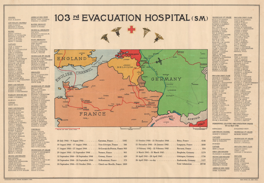
103rd Evacuation Hospital (SM).
1945 (undated) 17.5 x 25.5 in (44.45 x 64.77 cm) 1 : 3168000
1945 (undated) 17.5 x 25.5 in (44.45 x 64.77 cm) 1 : 3168000
Description
This is a rare 1945 World War II route map of the 103rd Evacuation Hospital in the European Theater of Operations - the only map was are aware of to detail a medical unit. One of only two known examples, this map provides an overview of the medical unit's wartime activities. We have been unable to locate a corresponding unit history for the 103rd Evacuation Hospital, making this map a critical piece of the broader history of World War II.
A Closer Look
The map depicts northwestern Europe from southern England to western Austria and from the Netherlands south to extreme northern Italy. A bright red line highlights the 103rd Evacuation Hospital's route across Europe, and cities labeled using capital letters are where the hospital set up. A few locations not on the 103rd's route are identified, including Paris, Metz, Strasbourg, Brussels, Antwerp, and Malmedy. The roster of the 103rd Evacuation Hospital appears to the left and right of the map. Below the map, the time spent in each city as the hospital advanced across France and Germany from July 20, 1944, until V-E Day is cataloged, along with the total number of admissions at each location.This Example in Focus
While the present example is not signed by its owner, some manuscript notations suggest what they experienced after V-E Day. A pencil line advances from Zeulenroda south through Plauen, Nürnberg, Munich, Stuttgart, Karlsruhe, and Mannheim. Augsburg, Heidelberg, and Schriesheim are added in manuscript. A fainter, perhaps dashed, line continues west from Frankfurt through Metz, Verdun, Reims, Paris, Rouen, and Le Havre, suggesting that this is the route the map's previous owner, and perhaps the entire evacuation hospital, took to get to the ship that would take them back to the United States. A manuscript airplane has been added over the dashed line between Cologne and Kassel.WWII Evacuation Hospitals
WWII evacuation hospitals were mobile units that were meant to follow the battle line. These hospitals had major medical and surgical facilities that could treat patients and served as gathering points to evacuate the worst cases. Patients could be at evacuation hospitals for as little as a few hours to as long as a few weeks, depending on their condition, the rate of admission, the unit's movements, and the available beds. There were two types of evacuation hospitals: 400-bed semi-mobile units and 750-bed mobile units.The 103rd Evacuation Hospital
The 103rd arrived in Europe in early July on either Omaha or Utah Beach (the historical record is unclear on this) and was one of the first field hospitals in Normandy. The hospital moved every 7 to 10 days and stayed as close to the battle line as possible. Based on the present route map, the 103rd was a semi-mobile hospital (that is our guess as to what the 'SM' in the title refers to). The 103rd followed the battle front across Europe and into Germany. It was also one of the units that liberated the Buchenwald Concentration Camp.World War II Route Maps
Maps tracing unit movements during World War II were created by both American and British forces during and after the war. As a genre, these maps represent a broad range of aesthetics, from the purely functional that label places and provide dates, to the artistic, even comic. Many combine the three and provide a visually striking but historically informative summary of the unit's peregrinations.Publication History and Census
This map was printed by Schmidt and Artinger and published by Loffler and Company in Greiz, Germany. We note one other cataloged example: Texas A and M University.Condition
Very good. Closed margin tears professionally repaired on verso. Creasing.
References
OCLC 1366202428.