This item has been sold, but you can get on the Waitlist to be notified if another example becomes available, or purchase a digital scan.
1951 Situation / Route Map of the 187th Airborne RCT in Korea during the Korean War
187thRCT-unknown-1951$600.00


Title
187 RCT. / To From the 187th Airborne RCT.
1951 (undated) 30.25 x 22.75 in (76.835 x 57.785 cm)
1951 (undated) 30.25 x 22.75 in (76.835 x 57.785 cm)
Description
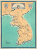
This is a 1951 situation/route map of the 187th Airborne Regimental Combat Team (RCT) during the first year of the Korean War (1950 - 1953), here in its only known example. Doubtless inspired by the tradition of division route maps popularized in World War II, this is the only such known map to focus on a specific unit during the Korean War.
A Closer Look
The map depicts the Korean peninsula from northeast China to Tsushima. Dates (beginning with the 187th arrival at Kimpo Airfield on September 26, 1950) and arrows follow the 187th's movements throughout Korea, highlighting the numerous battles fought by the regiment. White silhouettes of C-119 Flying Boxcars illustrate the 187th's movements by air to Kimpo, the airborne assault on Sukchon and Sunchon, and the airborne assault at Munsan-Ni. Highways and rivers are the only other notations present, including the highway between Pyongyang and Seoul, which the 187th had to secure in October 1950.187th RCT during the First Year of the Korean War
The 187th RCT left Camp Campbell, Kentucky, for Japan on September 1, 1950. The regiment had orders to report to the Far East Command and enter the Korean War. The 187th RCT arrived in Korea at Kimpo Airfield while under enemy fire on September 24, 1950. Their mission was to clear the Kimpo Peninsula of the retreating North Korean forces. On October 20, 1950, the 187th RCT took part in the airborne combat drop near the towns of Sukchon and Sunchon as part of the Battle of Yongju and continued fighting in North Korea for the next few months. The RCT was given the responsibility of holding Pyongyang, the North Korean capital, along with a supply line that reached all the way to Seoul, where they were stationed in early December as the UN forces began retreating due to the sustained Chinese offensive. The RCT completed its withdrawal from Pyongyang to Wonju on December 18, and the Chinese entered Pyongyang a few hours later. At Wonju, back on the South Korean side of the 38th Parallel, the RCT held the line until January 19, when it was relieved by the 38th Infantry Regiment. The RCT held positions on the line until February 28, 1951, when they were pulled to prepare for the parachute drop at Munsan-Ni. The parachute assault at Musan-Ni, codenamed Operation Tomahawk, took place on March 23, 1951, with the 187th RCT in the lead. Operation Tomahawk was part of Operation Courageous, which had the objective of trapping portions of the Chinese and North Korean armies between the Ham and Imjin Rivers. (Operation Tomahawk was the last combat jump of the Korean War and was the US Army's last combat jump until Operation Junction City in 1967 during the Vietnam War.) The 187th continued in combat until about June 26, 1951, when it was redeployed to Japan. The 187th RCT returned to Korea twice more before the end of the Korean War.Publication History and Census
This map was created by an unknown artist and published c. 1951. This is the only known cataloged example.Condition
Good. Wear along original fold lines. Creasing. Slight loss at a few fold intersections. Verso repairs to fold separations. Light dampstaining.