This item has been sold, but you can get on the Waitlist to be notified if another example becomes available, or purchase a digital scan.
1945 1st Signal Battalion World War II Route Map of North Africa and Europe
1stSignalBattalion-unknown-1945$325.00


Title
Torch. Husky. Anvil. Dragoon. Rush and Wait.
1945 (dated) 13.75 x 19.25 in (34.925 x 48.895 cm)
1945 (dated) 13.75 x 19.25 in (34.925 x 48.895 cm)
Description
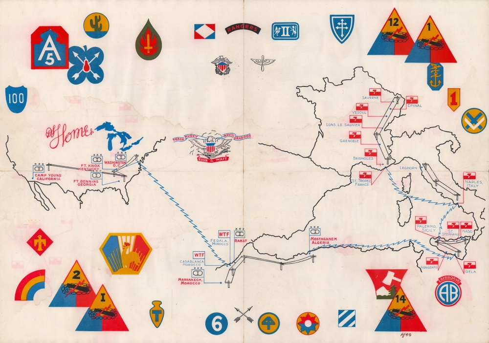
This is a 1945 1st Signal Battalion World War II route map of North Africa and Europe, a previously uncatalogued piece in a long-overlooked category of World War II cartography. The present map is noteworthy for being published February or March 1945, before the war's end most other similar maps of the European theater were published after the fighting ended in May.
A Closer Look
The map follows the battalion's movements from activation at Fort Knox, Kentucky. Blue 'radio signals' and black telegraph and telephone wires trace their activities. The 'radio signals' are used to highlight amphibious movements, which illustrate but do not label the battalions participation in Operation Torch (the invasion of North Africa), Operation Husky (the invasion of Sicily), Operation Avalanche (not identified here but the amphibious invasion of Naples), Operation Anvil (the first codename for the Allied landing in Provence which appears here but was not used), and Operation Dragoon (the invasion of southern France). The wires depict the battalion's overland movements around the United States, across North Africa, through Sicily, north from Naples to Leghorn in Italy, and from St. Tropez on the French Riviera north to Saverne. Unit insignia surround the map (although not one appears to be for the 1st Signal Battalion) and must reference all the units the battalion supported during the war.Verso Content
Text covers the verso. A battalion roster fills the left half of the sheet and is divided between the Headquarters and Headquarters Company and Company 'A'. Intriguingly, in small type below the roster, the sentence 'This document must not fall into enemy hands' is included, underscoring the fact that this piece was a wartime product. On the right, a short unit history provides a summary of 1943 and 1944, and candidly discusses the battalion's activities and movements during those two years. It ends in February 1945, three months before the end of the war.World War II Route Maps
Maps tracing unit movements during World War II were created by both American and British forces during and after the war. As a genre, these maps represent a broad range of aesthetics, from the purely functional that label places and provide dates, to the artistic, even comic. Many combine the three and provide a visually striking but historically informative summary of the unit's peregrinations.Publication History and Census
This map was created by an unknown artist and published in February or March 1945 based on the verso text, 'Now it's February 1st again and a fourth anniversary of the battalion; the task begun so long ago remains to be finished'. This is the only known surviving example of the present map.Condition
Average. Large damp stain through central portion of map. Verso repairs to fold separations. Text on verso.