This item has been sold, but you can get on the Waitlist to be notified if another example becomes available, or purchase a digital scan.
1945 Larssen Pictorial World War II Route Map of the First U.S. Army in Europe
1stUSArmy-larssen-1945$175.00

Title
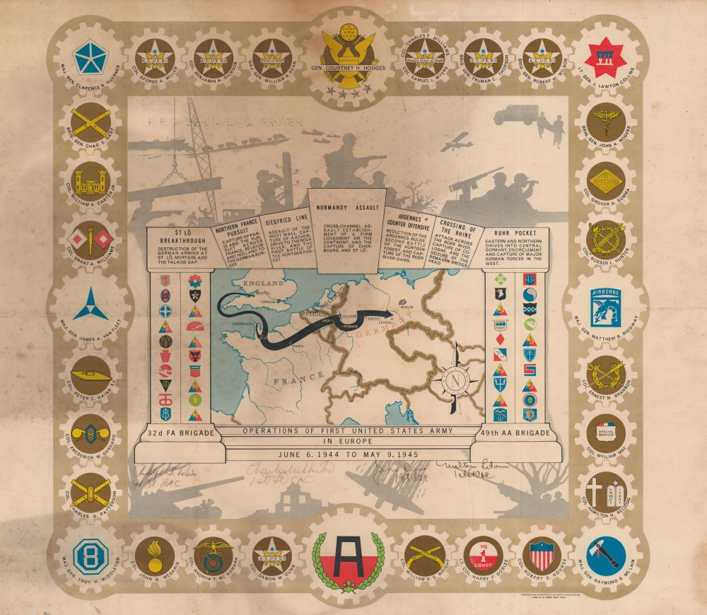
Operations of the First United States Army in Europe June 6, 1944 to May 9, 1945.
1945 (dated) 18 x 18 in (45.72 x 45.72 cm)
1945 (dated) 18 x 18 in (45.72 x 45.72 cm)
Description
One of the more overtly decorative pieces in the genre, this is a 1945 Einar Larssen pictorial World War II route map of the First United States Army in Europe. The map traces the path of the First Army as it traveled throughout Europe.
A Closer Look
A map of the First U.S. Army's route from Bristol, England, to Normandy, France, and finally the Elbe River in Germany appears at center. Very little detail is included on the map, with only 11 cities labeled: London, Paris, Aachen, Remagen, Leipzig, and Berlin. The map is framed by columns, a plinth, and an arch. Division patches adorn both columns, with the map's title appearing on the plinth. The First Army's campaigns are listed on the stones in the arch, with the Normandy Assault occupying the keystone. The St. Lo Breakthrough, the Siegfried Line, the Ardennes Counter Offensive, and Crossing the Rhine are among the other campaigns highlighted on the 'stones'. Around the arch, illustrations of Army life appear in shadow, including soldiers in a tank turret, a squad on patrol, engineers working, and antiaircraft artillery successfully downing an enemy plane. The whole is surrounded by the insignia of various commands, including the Signal Corps, the Engineers, and the Medical Corps.Signatures
Below the plinth, four signatures are included. These are four officers in the CAC, a lieutenant colonel and three first lieutenants.World War II Route Maps
Maps tracing unit movements during World War II were created by both American and British forces during and after the war. As a genre, these maps represent a broad range of aesthetics, from the purely functional that label places and provide dates, to the artistic, even comic. Many combine these three aspects and provide a visually striking but historically informative summary of the unit's peregrinations.Publication History and Census
This map was drawn by Einar Larssen and drafted and reproduced by the 654th Engineer Battalion of the First United States Army in May 1945. We note three examples cataloged in OCLC which are part of the collections at the University of Illinois at Urbana Champaign, the Wisconsin Veterans Museum Research Center, and Texas A and M University.Cartographer
Einar Larssen (September 29, 1910 - December 16, 2003) was a Norwegian-American artist and cartographer. Born in Stavangar, Norway, Larssen immigrated to the United States in 1929. He graduated from the Pratt Institute in Brooklyn, New York, in 1941. He enlisted in the U.S. Army after graduation and was sent to London where he spent 11 months, earned the rank of technical sergeant, and became chief draftsman. Larssen participated in the D-day invasion of France and was part of the Battle of the Bulge. During his time in the Army, he earned a Bronze Star. After returning home from the war, Larssen pursued a career in the arts and worked as a commercial artist with Master Etching in Englewood, New Jersey. He retired in 1973. He married Johanne Kvia with whom he had one daughter. More by this mapmaker...
Condition
Average. Soiling. Close top and bottom margin. Manuscript signatures below map in pictorial border. Light wear along fold lines.