This item has been sold, but you can get on the Waitlist to be notified if another example becomes available.
1945 Davis World War II 20th Armored Division Pictorial Route Map of Europe
20thArmdCCA-davis-1945$475.00

Title
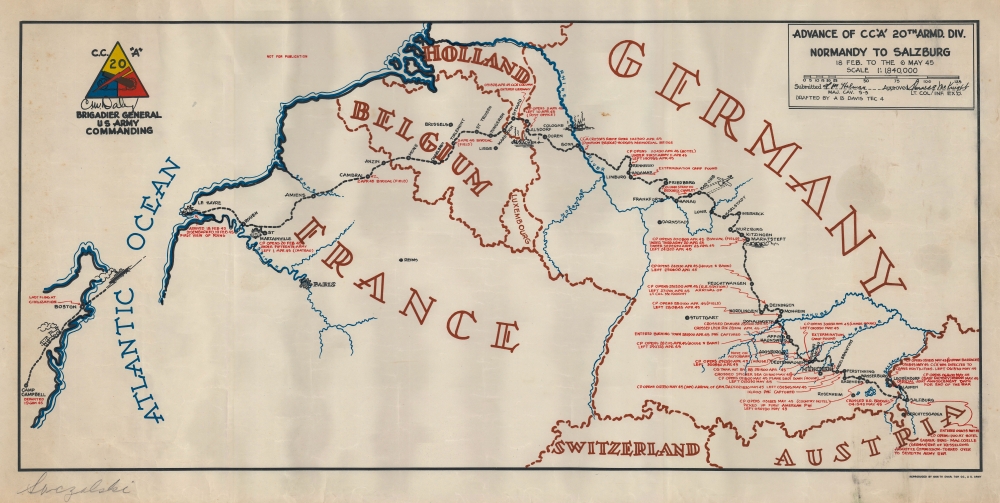
Advance of CC 'A' 20th Armd. Div. Normandy to Salzburg 18 Feb. to the 6 May 45.
1945 (dated) 13 x 27 in (33.02 x 68.58 cm) 1 : 1840000
1945 (dated) 13 x 27 in (33.02 x 68.58 cm) 1 : 1840000
Description
This is the rare 1945 A. B. Davis 20th Armored Division World War II pictorial route map of Europe. The map focuses on travels of the Combat Command A (CCA) of the 20th Armored Division.
Follow CCA, 20th Armored, Across Europe
The map follows CCA from Camp Campbell, Kentucky (where the division finished training) through Boston (where it embarked for the European Theater of Operations) to Le Havre, France. After leaving Le Havre, the division spent a month in combat preparation before entering the field on April 4, 1945, with CCA crossing the Rhine on April 10. Red text provides short summaries of CCA's advance, marking command posts, noting locations where POWs were captured, and identifying locations of two liberated extermination camps, including Dachau. Intriguingly, the end of the war appears in the same text as the rest of the events of the campaign. Unlike many other maps in the genre, relatively few pictorial vignettes are included. The few that do illustrate the train to Boston, the ship across the Atlantic, and the ruins of the various cities. The one combat related illustration is the appearance of 'Bed Check Charlie' (a nickname given by soldiers to solitary enemy planes that hovered over their lines) between Hanau and Bad Orb, when 'Charlie' strafed CCA's column.What is a Combat Command?
A combat command ('CC') was a part of an armored unit of the United States Army comparable in size with a brigade or regiment. Combat commands were originally developed in the 1930s and were used by the U.S. Army from 1942 until 1963. Unlike traditional brigades, a combat command was meant to be flexible and had no dedicated battalions. Different battalions would be assigned to a given 'CC' depending on the assigned mission and could include tank, armored infantry, and armored field artillery battalions along with smaller units of tank destroyers, mechanized cavalry, or engineers. The term combat command fell out of favor in the 1960s and similar units became known as regimental combat teams.World War II Allied Route Maps
Maps tracing unit movements during World War II were created by both American and British forces during and after the war. As a genre, these maps represent a broad range of aesthetics, from the purely functional that label places and provide dates, to the artistic, even comic. Many combine the three and provide a visually striking but historically informative summary of the unit's peregrinations. The brutal reality of the war, however, was never very far away in any of these works.Engineer Topographic Battalions during World War II
After World War II erupted in Europe, U.S. military officials realized that currently available maps of Europe were inadequate for modern artillery units or even tactical purposes. Their solution was the creation of engineer topographic battalions. Engineer Topographic Battalions provided technical support for the U.S. Army in the form of surveying, drafting, and printing maps for units on the ground. During the war, these battalions were responsible for creating accurate four-color topographic maps, along with surveying, printing, and distribution of these maps.Publication History and Census
This map was drawn by A. B. Davis, Tec 4 (Technician fourth grade) and was 'reproduced by the 666th Engineer Topographic Company' in 1945. As is printed on the map in the North Sea off the coast of Belgium, this piece, and many others like it, were 'not for publication' and was created specifically for the veterans of Combat Command A of the 20th Armored Division. We note a single cataloged example, at the Controvich Library, a private collection of WWII unit histories, route maps, and related materials. This is the only example we have encountered.Condition
Very good. Light soiling.