1871 Holmes Map of the Upper East Side, Manhattan, New York City
32-HarlemCommons-holmes-1871$3,500.00


Title
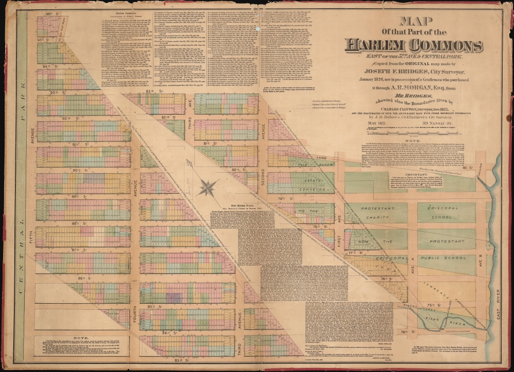
Map of that part of the Harlem Commons east of the 5th Ave. and Central Park copied from the original map made by Joseph F. Bridges, City Surveyor, January 1826, now in possession of a gentleman who purchased it through A.R. Morgan, Esq., from Mr. Bridges : showing also the boundaries given by Charles Clinton, Surveyor, Dec. 1825, and the inaccuracies of both the above-named maps, with other important information.
1871 (dated) 24 x 33 in (60.96 x 83.82 cm) 1 : 1800
1871 (dated) 24 x 33 in (60.96 x 83.82 cm) 1 : 1800
Description
This is an 1871 John Bute Holmes cadastral map of the Upper East Side in the borough of Manhattan in New York City. Constructed in an unusual manner, the map depicts the Upper East Side along a diagonal that stretches from Ninety-Sixth Street and Fifth Avenue to Seventy-Fourth Street and Avenue B. New York's now famous grid system acts as the base, along with the lots that were created by the 1811 Commissioner's Plan, which allows the neighborhood's evolution to be illustrated. One such detail is Fourth Avenue. Here, dashed lines mark the present sides of the avenue, several feet into the lots on either side. A large former estate is illustrated between Eightieth Street and Seventy-Eighth Street.
Holmes became fascinated by the early history of Manhattan real estate ownership, recognizing the wealth to be accrued by accurately understanding the history of city land ownership, division, and inheritance. Moreover, Holmes allied himself with the corrupt Tweed administration, assuring himself and his allies even greater wealth and political power from the eminent domain seizure of old Manhattan estates. Holmes created a series of maps, reminiscent of John Randall's 'Farm Maps', overlaid with property data, showing the borders of old estates, and notating the breakup of the lands among various heirs. The complex work of compiling the maps earned Holmes a fortune, with one newspaper suggesting on his death in 1887 that some of his individual maps were worth more than 30,000 USD. There is no complete carto-bibliography of Holmes' maps, but we believe there to be at least 50 maps, possibly more.
Harlem Commons
We have found a reference to the sale of the Harlem Commons in 1825, although we have been unable to unearth any concrete details about this event. Based on a close examination of the map, it seems likely that the Harlem Commons were sold by the then-independent city of Harlem to New York, which is why this map was commissioned. This may also explain the extremely strange diagonal design, because the border between New York and Harlem was a diagonal for much of its existence before Harlem was annexed by New York City. What we have managed to unearth about the Harlem Commons, which was very little, suggests that this land was used for the communal grazing of livestock when Harlem was still made up largely of rural farms and estates. The 1825 sale may simply have been a shift toward a more urban existence in Harlem and wanting to get the most out of the land before the city was annexed.Holmes' 'Farm Maps'
In the early 19th century most of Manhattan was undeveloped farm lands, the property of wealthy landowners with claims dating to the Dutch period of New York's history. The northern 2/3rd of Manhattan was dotted with farm lands and sprawling gentlemanly estates, many with great manor houses overlooking the Hudson River. The Commissioner's Plan of 1811 and the 1807 Commission Law, laid the street grid through many of these properties and gave the city the right to claim these lands under eminent domain, providing due compensation to the landowners. While this work occurred early in lower Manhattan, central and upper Manhattan were not formally acquired by the city until the mid-19th century.Holmes became fascinated by the early history of Manhattan real estate ownership, recognizing the wealth to be accrued by accurately understanding the history of city land ownership, division, and inheritance. Moreover, Holmes allied himself with the corrupt Tweed administration, assuring himself and his allies even greater wealth and political power from the eminent domain seizure of old Manhattan estates. Holmes created a series of maps, reminiscent of John Randall's 'Farm Maps', overlaid with property data, showing the borders of old estates, and notating the breakup of the lands among various heirs. The complex work of compiling the maps earned Holmes a fortune, with one newspaper suggesting on his death in 1887 that some of his individual maps were worth more than 30,000 USD. There is no complete carto-bibliography of Holmes' maps, but we believe there to be at least 50 maps, possibly more.
Provenance
This map was acquired as a part of a large collection of New York cadastral maps associated with the lawyer Ronald K. Brown, a Deed Commissioner operating in the late 19th and early 20th century with an office at 76 Nassau Street, New York - not far from Holmes' own office. Most of the maps in the collection, including the present map, bear Brown's stamp on the verso. The maps were passed to Dominic Anthony Trotta, a real estate agent working under Brown. Brown seems to have ceased business around 1919, but Trotta continued as a real estate agent, becoming a New York Tax Commissioner in 1934 under the Fiorello H. La Guardia administration. The maps remained with Trotta's heirs until our acquisition of the collection.Publication History and Census
This map was created and published by John Bute Holmes in 1866. Three examples are recorded in the OCLC as being part of the institutional collections at Princeton University, the New York State Library, and the University of Wisconsin - Milwaukee. Although uncatalogued, we believe that the New York Public Library also has an example.Cartographer
John Bute Holmes (March 31, 1822 - May 21, 1887) was an Irish civil engineer, city surveyor, and mapmaker based in New York City in the middle to latter 19th century. Holmes was described as a 'short, stout man, with curly gray hair, a smooth face, and a short, thick neck.' Holmes' father-in-law supplied funds for him to immigrate to America in 1840 and shortly thereafter, in 1844, he established himself in New York City. He briefly returned to Europe before once again settling in New York City in 1848. Apparently, according to several New York Times articles dating to the 1870s, Holmes was a man of dubious personal and moral character. He was involved in several legal disputes most of which were associated with his outrageous - even by modern standards - womanizing. In 1857 he was convicted of forgery of a marriage document and sentenced to 15 years of hard labor at Sing Sing, of which he served 5 before wealthy associates interceded on his behalf for an early release. Holmes seems to have been married to several different women at the same time and to have had an unfortunate attraction to exceptionally young women - one of whom, 16 year old May Chamberlayne claimed to be his wife and sued him for 50,000 USD. On another occasion he was found guilty of killing Brooklyn policeman David Gourly with whose wife he 'had been intimate.' Another woman, Miss Abrams, who he hired as a housekeeper, was repeatedly attacked by Holmes and ultimately driven to madness and was consigned to Bellevue Hospital, where she died. Although he attempted to flee the country rather than face conviction for 4th degree manslaughter, he was ultimately arrested and served one year in prison. During the American Civil War he ran for Alderman of the First Ward, in New York. Despite his legal issues, Holmes was a man of considerable means, with a personal fortune estimated between 100,000 and 500,000 USD - a significant sum in the late 19th century. Much of his wealth is associated with a series of important cadastral maps produced between 1867 and 1875 while he was employed as a surveyor and civil engineer under the corrupt Tweed regime. When Holmes died of an 'apoplectic fit' there was considerable wrangling over his estate among his 7 heirs and 11 children. The cream of his estate where his maps, some of which were valued at more than 30,000 USD in 1887. Holmes lived on a large farm-estate in Fanwood New Jersey. More by this mapmaker...
Condition
Good. Original linen exhibits some verso reinforcement. Minor wear and some damage along original fold lines. Even overall toning. Slight loss along margins. Not all silk edging intact.
References
OCLC 50550815.