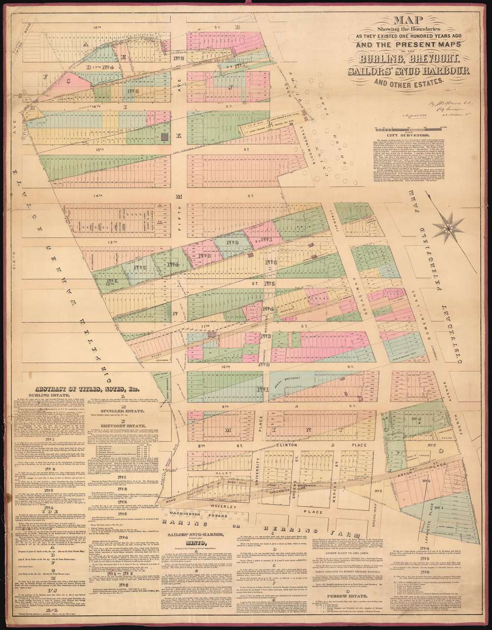
1882 Holmes Map of Greenwich Village, Manhattan, New York City
39-Burling-holmes-1882$3,500.00


Title
Map Showing the Boundaries As They Existed One Hundred Years Ago of the Burling, Brevoort, Sailors' Snug Harbour And Other Estates.
1882 (dated) 38.5 x 30 in (97.79 x 76.2 cm) 1 : 1200
1882 (dated) 38.5 x 30 in (97.79 x 76.2 cm) 1 : 1200
Description
This is a John Bute Holmes 1882 cadastral map of eastern Greenwich Village, one of New York City's most famous neighborhoods, the cradle of the LGBT movement, and the home of New York University. The map depicts the neighborhood from Sixth Avenue to Fourth Avenue and from 18th Street to Waverly Place and Washington Square Park. Highly detailed, Holmes visually conveys the history of the development of this part of Greenwich Village, with the original lots illustrated in dotted lines superimposed over the street grid and the much smaller lots that make up the city blocks. Each lot within each city block is identified numerically. A brief history of the ownership of estates and other tracts in the neighborhood is printed on the map along the left side and the bottom.
Holmes became fascinated by the early history of Manhattan real estate ownership, recognizing the wealth to be accrued by accurately understanding the history of city land ownership, division, and inheritance. Moreover, Holmes allied himself with the corrupt Tweed administration, assuring himself and his allies even greater wealth and political power from the eminent domain seizure of old Manhattan estates. Holmes created a series of maps, reminiscent of John Randall's 'Farm Maps', overlaid with property data, showing the borders of old estates, and notating the breakup of the lands among various heirs. The complex work of compiling the maps earned Holmes a fortune, with one newspaper suggesting on his death in 1887 that some of his individual maps were worth more than 30,000 USD. There is no complete carto-bibliography of Holmes' maps, but we believe there to be at least 50 maps, possibly more.
Sailor's Snug Harbor, previously known as the Minto Farm
Captain Robert Richard Randall(1750 - 1801) was an American sailor who amassed an impressive fortune capturing prizes on the High Seas. Randall purchased the former Elliot estate in then-rural Greenwich Village in 1796 following his father's death. The now-Randall estate comprised 24 acres between today's Fourth and Fifth Avenues and Waverly Place and Ninth Street. Randall, in his will (drawn up by Alexander Hamilton), established what became known as 'Sailor's Snug Harbor', a home for retired sailors, and arguably the first charitable organization in the United States. After Randall's death, the children of his half-brother challenged his will in court, and the court sided in favor of Sailor's Snug Harbor. The organization decided that, instead of occupying the land in Manhattan, they would subdivide it and lease it out, since the area was becoming more and more popular with the elite. Sailor's Snug Harbor used the money from its Greenwich Village leases to acquire 160 acres of land on Staten Island in 1831 to fulfill the stipulations in Randall's will.Holmes' 'Farm Maps'
In the early 19th century most of Manhattan was undeveloped farm lands, the property of wealthy landowners with claims dating to the Dutch period of New York's history. The northern 2/3rd Manhattan was dotted with farm lands and sprawling gentlemanly estates, many with great manor houses overlooking the Hudson River. The Commissioner's Plan of 1811 and the 1807 Commission Law, laid the street grid through many of these properties and gave the city the right to claim these lands under eminent domain, providing due compensation to the landowners. While this work occurred early in lower Manhattan, central and upper Manhattan were not formally acquired by the city until the mid-19th century.Holmes became fascinated by the early history of Manhattan real estate ownership, recognizing the wealth to be accrued by accurately understanding the history of city land ownership, division, and inheritance. Moreover, Holmes allied himself with the corrupt Tweed administration, assuring himself and his allies even greater wealth and political power from the eminent domain seizure of old Manhattan estates. Holmes created a series of maps, reminiscent of John Randall's 'Farm Maps', overlaid with property data, showing the borders of old estates, and notating the breakup of the lands among various heirs. The complex work of compiling the maps earned Holmes a fortune, with one newspaper suggesting on his death in 1887 that some of his individual maps were worth more than 30,000 USD. There is no complete carto-bibliography of Holmes' maps, but we believe there to be at least 50 maps, possibly more.
Provenance
This map was acquired as a part of a large collection of New York cadastral maps associated with the layer Ronald K. Brown, a Deed Commissioner operating in the late 19th and early 20th century with an office at 76 Nassau Street, New York - not far from Holmes' own office. Most of the maps in the collection, including the present map, bear Brown's stamp on the verso. The maps were passed to Dominic Anthony Trotta, a real estate agent working under Brown. Brown seems to have ceased business around 1919, but Trotta continued as a real estate agent, becoming a New York Tax Commissioner in 1934 under the Fiorello H. La Guardia administration. The maps remained with Trotta's heirs until our acquisition of the collection.Publication History and Census
This map was created and published by John Bute Holmes in 1882. It is of considerable rarity. The OCLC identifies only 3 examples: at Princeton, the New York State Library, and Harvard. Although uncatalogued, we believe the New York Public Library may have an example.Cartographer
John Bute Holmes (March 31, 1822 - May 21, 1887) was an Irish civil engineer, city surveyor, and mapmaker based in New York City in the middle to latter 19th century. Holmes was described as a 'short, stout man, with curly gray hair, a smooth face, and a short, thick neck.' Holmes' father-in-law supplied funds for him to immigrate to America in 1840 and shortly thereafter, in 1844, he established himself in New York City. He briefly returned to Europe before once again settling in New York City in 1848. Apparently, according to several New York Times articles dating to the 1870s, Holmes was a man of dubious personal and moral character. He was involved in several legal disputes most of which were associated with his outrageous - even by modern standards - womanizing. In 1857 he was convicted of forgery of a marriage document and sentenced to 15 years of hard labor at Sing Sing, of which he served 5 before wealthy associates interceded on his behalf for an early release. Holmes seems to have been married to several different women at the same time and to have had an unfortunate attraction to exceptionally young women - one of whom, 16 year old May Chamberlayne claimed to be his wife and sued him for 50,000 USD. On another occasion he was found guilty of killing Brooklyn policeman David Gourly with whose wife he 'had been intimate.' Another woman, Miss Abrams, who he hired as a housekeeper, was repeatedly attacked by Holmes and ultimately driven to madness and was consigned to Bellevue Hospital, where she died. Although he attempted to flee the country rather than face conviction for 4th degree manslaughter, he was ultimately arrested and served one year in prison. During the American Civil War he ran for Alderman of the First Ward, in New York. Despite his legal issues, Holmes was a man of considerable means, with a personal fortune estimated between 100,000 and 500,000 USD - a significant sum in the late 19th century. Much of his wealth is associated with a series of important cadastral maps produced between 1867 and 1875 while he was employed as a surveyor and civil engineer under the corrupt Tweed regime. When Holmes died of an 'apoplectic fit' there was considerable wrangling over his estate among his 7 heirs and 11 children. The cream of his estate where his maps, some of which were valued at more than 30,000 USD in 1887. Holmes lived on a large farm-estate in Fanwood New Jersey. More by this mapmaker...
Condition
Good. Original linen exhibits some verso reinforcement. Minor wear and some damage along original fold lines. Verso repairs to fold separations. Even overall toning.
References
OCLC 50574958.