This item has been sold, but you can get on the Waitlist to be notified if another example becomes available, or purchase a digital scan.
1945 WWII Route Map of the 3rd Algerian Infantry: Africa, Italy, France, Germany
3eDivInfAlgerienne-2ebureau-1945$475.00


Title
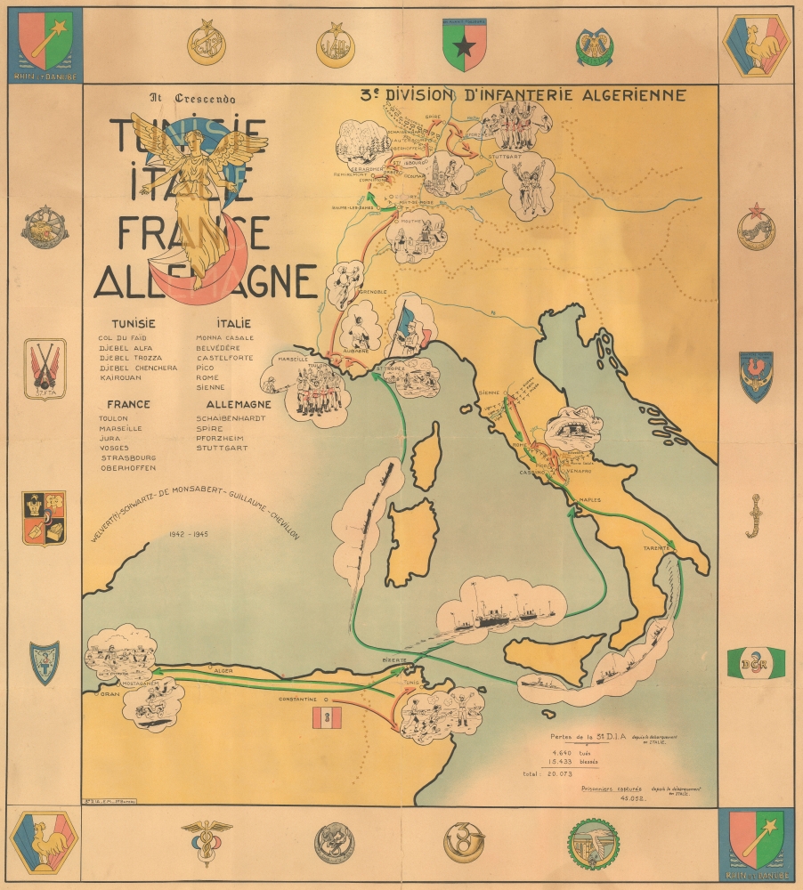
3e Division D'Infanterie Algerienne Tunisie Italie France Allemagne.
1945 (undated) 32 x 29 in (81.28 x 73.66 cm)
1945 (undated) 32 x 29 in (81.28 x 73.66 cm)
Description
This is a rare 1945 World War II pictorial route map of the 3rd Algerian Infantry Division in North Africa, Italy, France, and Germany. The map follows the Division from activation until the end of the war and uses vignette illustrations to highlight important moments during the Division's war. This piece holds historical significance as a route map dedicated to a colonial unit. It is a glimpse into the wartime experiences of a group that is often overlooked by popular histories published today.
A Closer Look
Red and green arrows follow the Division's movements from activation in Constantine, Algeria, until the end of the war in Stuttgart. Red arrows highlight combat actions, with these appearing in Tunisia during the encirclement of the Afrika Korps, in Italy along the Gustave Line, and to Rome and Sienna. In France, these arrows highlight the Operation Dragoon landings in Provence and the liberation of St. Tropez, Toulon, and Marseille. Then the arrows proceed north through Grenoble to Mouthe and Strasbourg before crossing the Siegfried Line into Germany and across the Rhine to Stuttgart. The green arrows illustrate noncombat movements, such as those in North Africa preparing for the Division's movement to Naples and traveling through Italy to prepare for Operation Dragoon. Vignettes shaped as clouds capture moments from the Division's campaigns. Among these are capturing Germans in Tunisia, a German machine gun nest along the Gustave Line in Italy, landing on the beach at St. Tropez, capturing Germans in Toulon and Marseille, chasing Germans north through France, protecting Strasbourg, and celebrating the end of the war in Stuttgart. The Division's insignia, a 3 created by 3 crescents overlaid with an angel with outstretched arms, occupies the upper left corner above the list of battles fought by the Division. The Division's losses are chronicled in the lower right corner and amount to 4,640 killed and 15,433 wounded. Unit insignia occupy the border.The 3rd Algerian Infantry Division
The 3rd Algerian Infantry Division was formed after the Allies liberated North Africa and was part of the Army of Africa. The division was activated on May 1, 1943, and participated in the Tunisian campaign. It was also part of the French Expeditionary Corps that fought in Italy in 1944. The Division saw action at Monte Cassino and helped break through the Gustav Line. The Division took part in the August 15, 1944, Operation Dragoon landings in Provence, France, and helped liberate Toulon and Marseille before heading north up the Rhône Valley. The Division fought in the Vosges in September and October 1944 and continued northeast, liberating parts of the Belfort and Gérardmer sectors. In December 1944, the Division assaulted Colmar and the highlands of Worhof. It helped defend Strasbourg in January 1945 and, by March 1945, was marching through Germany. It crossed the Rhine on March 31, 1945, before reaching Stuttgart. The Division was dissolved on April 15, 1946.World War II Route Maps
Maps tracing unit movements during World War II were created by American and British forces during and after the war. As a genre, these maps represent a broad range of aesthetics, from the purely functional that label places and provide dates, to the artistic, even comic. Many combine the three and provide a visually striking but historically informative summary of the unit's peregrinations. Maps of units other than those from the United States are rare, and those highlighting colonial divisions are even scarcer, making this piece a truly incredible find.Publication History and Census
This map was created by the 3rd Algerian Infantry Division's 2e Bureau, or Intelligence Section, c. 1945. We note only two other instances when this map has appeared on the private market.Condition
Good. Overall toning. Vertical centerfold reinforcement on verso. Slight infill at a couple fold intersections.