1869 Holmes Map of Chelsea, 19th to 29th Streets, Manhattan, New York City
42-Chelsea-holmes-1869$1,800.00


Title
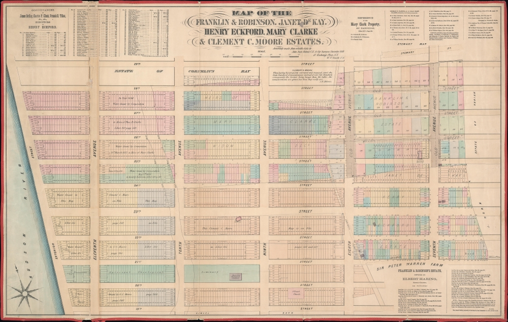
Map of the Franklin and Robinson, Janet De Kay, Henry Eckford, Mary Clarke and Clement C. Moore Estates.
1869 (dated) 22.5 x 35 in (57.15 x 88.9 cm) 1 : 1800
1869 (dated) 22.5 x 35 in (57.15 x 88.9 cm) 1 : 1800
Description
A rare separate issue 1869 John Bute Holmes map of the Chelsea neighborhood of Manhattan, New York City. The map captures the break-up of these lands to accommodate the Manhattan grid system.
Holmes became fascinated by the early history of Manhattan real estate ownership, recognizing the wealth to be accrued by accurately understanding the history of city land ownership, division, and inheritance. Moreover, Holmes allied himself with the corrupt Tweed administration, assuring himself and his allies even greater wealth and political power from the eminent domain seizure of old Manhattan estates. Holmes created a series of maps, reminiscent of John Randall's 'Farm Maps', overlaid with property data, showing the borders of old estates, and notating the breakup of the lands among various heirs. The complex work of compiling the maps earned Holmes a fortune, with one newspaper suggesting on his death in 1887 that some of his individual maps were worth more than 30,000 USD. There is no complete carto-bibliography of Holmes' maps, but we believe there to be at least 50 maps, possibly more.
A Closer Look
The map covers from the Hudson River to 7th Avenue and from 19th to 29th street. Like all of Holmes' important neighborhood maps, the present map focuses on the mid-19th century breakup of the great Manhattan estates into property lots. The present example the focuses on the estates of Franklin, Robinson, heiress Janet de Kay (1802 - 1854), shipbuilder Henry Eckford (1775 - 1832), heiress Mary Clarke, and the academic and heir Clement Clarke Moore (1779 - 1863).The Chelsea Farm
Retired British Army Captain Thomas Clarke acquired a large 94 acre country estate in Manhattan (as odd as that sounds) in 1750. The deed, which was quoted in the New York Times, describes it asall that farm or plantation in the Bassau Bowery on the West side of Manhattan Island, bounded on the west by the Hudson River, on the east by land of John Horn, on the north by the land of Widow Cowenhoven and Brandt Schuyer, on the south by land of Sir Peter Warren and Yellis Mandeville.In modern terms, the approximate extant of the estate was from 8th Avenue to the Hudson River from 21st to 24th streets. Here, Clarke built a grand mansion which he named Chelsea, referencing London's Chelsea Hospital, a home for aged veterans, which he in fact was. The lands were eventually broken up among his heirs until the mid-19th century, when the estates were fully broken up into smaller lots to accommodate the Manhattan grid system and rapid urbanization.
A 19th Century Description of the Map
We cannot resist quoting this overwrought 1878 description of Holmes' map issued in Historical Magazine (Page 268),The estates described in this map, extend along the exterior line, on the North-river, from Nineteenth to Twenty-eighth Streets; thence along the latter Street to the Tenth Avenue; thence to Ninth Avenue seventy-five feet North of Twenty-eighth Street; thence southerly about two hundred feet; thence to the old Fitzroy Road - Twenty-seventh Street near Eighth Avenue; thence, along that old road, nearly to Twenty-ninth Street; thence, easterly, to Twenty-ninth Street, about two hundred feet easterly from the Seventh Avenue; thence nearly parallel with the Seventh Avenue, to Twenty-first Street; thence along the latter Street to the Fitzroy Road near the Eighth Avenue; thence along the Fitzroy Road to Nineteenth Street; and thence, along the latter Street. to the place beginning.Quite the long winded description!
Holmes' 'Farm Maps'
In the early 19th century most of Manhattan was undeveloped farmlands, the property of wealthy landowners with claims dating to the Dutch period of New York's history. The northern 2/3rd Manhattan was dotted with farmlands and sprawling gentlemanly estates, many with great manor houses overlooking the Hudson River. The Commissioner's Plan of 1811 and the 1807 Commission Law, laid the street grid through many of these properties and gave the city the right to claim these lands under eminent domain, providing due compensation to the landowners. While this work occurred early in lower Manhattan, central and upper Manhattan were not formally acquired by the city until the mid-19th century.Holmes became fascinated by the early history of Manhattan real estate ownership, recognizing the wealth to be accrued by accurately understanding the history of city land ownership, division, and inheritance. Moreover, Holmes allied himself with the corrupt Tweed administration, assuring himself and his allies even greater wealth and political power from the eminent domain seizure of old Manhattan estates. Holmes created a series of maps, reminiscent of John Randall's 'Farm Maps', overlaid with property data, showing the borders of old estates, and notating the breakup of the lands among various heirs. The complex work of compiling the maps earned Holmes a fortune, with one newspaper suggesting on his death in 1887 that some of his individual maps were worth more than 30,000 USD. There is no complete carto-bibliography of Holmes' maps, but we believe there to be at least 50 maps, possibly more.
Provenance
This map was acquired as a part of a large collection of New York cadastral maps associated with the layer Ronald K. Brown, a Deed Commissioner operating in the late 19th and early 20th century with an office at 76 Nassau Street, New York - not far from Holmes' own office. Most of the maps in the collection, including the present map, bear Brown's stamp on the verso. The maps were passed to Dominic Anthony Trotta, a real estate agent working under Brown. Brown seems to have ceased business around 1919, but Trotta continued as a real estate agent, becoming a New York Tax Commissioner in 1934 under the Fiorello H. La Guardia administration. The maps remained with Trotta's heirs until our acquisition of the collection.Publication History and Census
This map was issued by John Bute Holmes in 1869. Like all of Holmes' maps, this map was separately issued and is quite rare. The present map is one of only 5 known examples, the others being hold by the New York State Library, the New York Historical Society, and Princeton University. A fifth is known in a private collection.Cartographer
John Bute Holmes (March 31, 1822 - May 21, 1887) was an Irish civil engineer, city surveyor, and mapmaker based in New York City in the middle to latter 19th century. Holmes was described as a 'short, stout man, with curly gray hair, a smooth face, and a short, thick neck.' Holmes' father-in-law supplied funds for him to immigrate to America in 1840 and shortly thereafter, in 1844, he established himself in New York City. He briefly returned to Europe before once again settling in New York City in 1848. Apparently, according to several New York Times articles dating to the 1870s, Holmes was a man of dubious personal and moral character. He was involved in several legal disputes most of which were associated with his outrageous - even by modern standards - womanizing. In 1857 he was convicted of forgery of a marriage document and sentenced to 15 years of hard labor at Sing Sing, of which he served 5 before wealthy associates interceded on his behalf for an early release. Holmes seems to have been married to several different women at the same time and to have had an unfortunate attraction to exceptionally young women - one of whom, 16 year old May Chamberlayne claimed to be his wife and sued him for 50,000 USD. On another occasion he was found guilty of killing Brooklyn policeman David Gourly with whose wife he 'had been intimate.' Another woman, Miss Abrams, who he hired as a housekeeper, was repeatedly attacked by Holmes and ultimately driven to madness and was consigned to Bellevue Hospital, where she died. Although he attempted to flee the country rather than face conviction for 4th degree manslaughter, he was ultimately arrested and served one year in prison. During the American Civil War he ran for Alderman of the First Ward, in New York. Despite his legal issues, Holmes was a man of considerable means, with a personal fortune estimated between 100,000 and 500,000 USD - a significant sum in the late 19th century. Much of his wealth is associated with a series of important cadastral maps produced between 1867 and 1875 while he was employed as a surveyor and civil engineer under the corrupt Tweed regime. When Holmes died of an 'apoplectic fit' there was considerable wrangling over his estate among his 7 heirs and 11 children. The cream of his estate where his maps, some of which were valued at more than 30,000 USD in 1887. Holmes lived on a large farm-estate in Fanwood New Jersey. More by this mapmaker...
Condition
Very good. Minor tallow stains, left side. Original linen backing and edging.
References
OCLC 50450966.