1868 Holmes Map of Soho West (Mercer, Thomson, Spring, Macdougal, Prince)

48-WestBayardFarms-holmes-1868
$4,500.00
Map of the West Bayard Farm The Property of Nicholas and Stephen Bayard and the John Dyckman Dcd. Property. - Main View
Processing...

1868 Holmes Map of Soho West (Mercer, Thomson, Spring, Macdougal, Prince)

48-WestBayardFarms-holmes-1868

Soho.
$4,500.00

Title


Map of the West Bayard Farm The Property of Nicholas and Stephen Bayard and the John Dyckman Dcd. Property.
  1868 (dated)     24.5 x 35.5 in (62.23 x 90.17 cm)     1 : 1200

Description


This is an 1866 John Bute Holmes cadastral maps of the western part of Soho, one of New York City's most interesting and vibrant neighborhoods. These lands were once part of the West Bayard Farm.
A Closer Look
The map covers from Howard Street to Amity Lane and from Broadway to 8th Street, including some of Manhattan's most iconic streets: Bleeker, MacDougal, Sullivan, Thompson, Green, Mercer, Spring Street, Prince Street, Broome Street, and Grand Street, among others. It employs color coding, overprinting, and an alpha-numeric system to identify both old property lines dating to the earliest days of Manhattan's development and the street grid compliant with the 1811 Commissioner's Plan.
Bayard Farm
The map shows the 100-acre farm of Nicholas and Stephen Bayard, which was in their family in the 17th century. As noted on the map, in 1789, the land passed to trustees Daniel Ludlow and Brockholst Livingston. They then conveyed the land to several others, including Aaron Burr. The present map covers the west section of the farm; Holmes made an accompanying map of the east section, which we have also handled.
Holmes' 'Farm Maps'
In the early 19th century, most of Manhattan was undeveloped farmland, the property of wealthy landowners with claims dating to the Dutch period. The northern 2/3rd of Manhattan was dotted with farms and gentlemanly estates, many with grand manor houses overlooking the Hudson River. The Commissioner's Plan of 1811 and the 1807 Commission Law, laid the street grid through many of these properties and gave the city the right to claim these lands under eminent domain, providing due compensation to the landowners. While this work occurred early in lower Manhattan, central and upper Manhattan were not formally acquired by the city until the mid-19th century.

Holmes became fascinated by the early history of Manhattan real estate ownership, recognizing the wealth to be accrued by accurately understanding the history of city land ownership, division, and inheritance. Moreover, Holmes allied himself with the corrupt Tweed administration, assuring himself and his allies even greater wealth and political power from the eminent domain seizure of old Manhattan estates. Holmes created a series of maps, reminiscent of John Randall's 'Farm Maps', overlaid with property data, showing the borders of old estates and notating the breakup of the lands among various heirs. The complex work of compiling the maps earned Holmes a fortune, with one newspaper suggesting on his death in 1887 that some of his individual maps were worth more than 30,000 USD. There is no complete carto-bibliography of Holmes' maps, but we believe there to be at least 50 maps, possibly more.
Provenance
This map was acquired as a part of a collection of New York cadastral maps associated with the lawyer Ronald K. Brown, a Deed Commissioner operating in the late 19th and early 20th century with an office at 76 Nassau Street, New York - not far from Holmes' own office. Most of the maps in the collection, including the present map, bear Brown's stamp on the verso. The maps were passed to Dominic Anthony Trotta, a real estate agent working under Brown. Brown seems to have ceased business around 1919, but Trotta continued as a real estate agent, becoming a New York Tax Commissioner in 1934 under Fiorello H. La Guardia. The maps remained with Trotta's heirs until our acquisition of the collection.
Publication History and Census
Holmes based this map on the survey work of Casimir T. Goerk, the famed city surveyor behind the Commissioners Plan. It was engraved by Thomas Bonar, Nassau Street. The map exists in only one edition, as here, published in 1868. It is of considerable rarity. The OCLC identifies only 2 examples: at Princeton and the New York State Library. Although uncatalogued, we believe the New York Public Library may have an example. There is at least one other example in private hands.

CartographerS


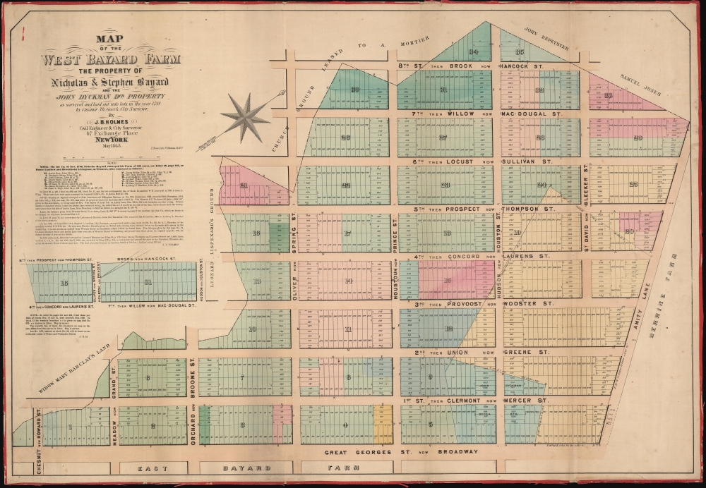
John Bute Holmes (March 31, 1822 - May 21, 1887) was an Irish civil engineer, city surveyor, and mapmaker based in New York City in the middle to latter 19th century. Holmes was described as a 'short, stout man, with curly gray hair, a smooth face, and a short, thick neck.' Holmes' father-in-law supplied funds for him to immigrate to America in 1840 and shortly thereafter, in 1844, he established himself in New York City. He briefly returned to Europe before once again settling in New York City in 1848. Apparently, according to several New York Times articles dating to the 1870s, Holmes was a man of dubious personal and moral character. He was involved in several legal disputes most of which were associated with his outrageous - even by modern standards - womanizing. In 1857 he was convicted of forgery of a marriage document and sentenced to 15 years of hard labor at Sing Sing, of which he served 5 before wealthy associates interceded on his behalf for an early release. Holmes seems to have been married to several different women at the same time and to have had an unfortunate attraction to exceptionally young women - one of whom, 16 year old May Chamberlayne claimed to be his wife and sued him for 50,000 USD. On another occasion he was found guilty of killing Brooklyn policeman David Gourly with whose wife he 'had been intimate.' Another woman, Miss Abrams, who he hired as a housekeeper, was repeatedly attacked by Holmes and ultimately driven to madness and was consigned to Bellevue Hospital, where she died. Although he attempted to flee the country rather than face conviction for 4th degree manslaughter, he was ultimately arrested and served one year in prison. During the American Civil War he ran for Alderman of the First Ward, in New York. Despite his legal issues, Holmes was a man of considerable means, with a personal fortune estimated between 100,000 and 500,000 USD - a significant sum in the late 19th century. Much of his wealth is associated with a series of important cadastral maps produced between 1867 and 1875 while he was employed as a surveyor and civil engineer under the corrupt Tweed regime. When Holmes died of an 'apoplectic fit' there was considerable wrangling over his estate among his 7 heirs and 11 children. The cream of his estate where his maps, some of which were valued at more than 30,000 USD in 1887. Holmes lived on a large farm-estate in Fanwood New Jersey. More by this mapmaker...


Thomas Bonar (1820 - May 19, 1891) was a New York City engraver and lithographer active in the second half of the 19th century. Bonar was born in Edinburgh, Scotland. He is described as 'the handsomest man to be seen in New York,' notable for his exceptional height, long white hair, and erect posture (Brooklyn Daily Eagle, May 20, 1891). He emigrated to New York City around 1847, which also corresponds to the earliest records of his work. From 1860 to 1863 worked for the New York Herald, producing engravings and 'war maps' illustrating Civil War events. He later worked for the Telegraph and the Tribune. In 1850, his work is associated with the firm of 'Bonar and Cummings', who produced engravings for the Methodist Book Room and Methodist Magazine. He retired from the lithography business around 1886 to devote himself to home life, travel, and the New York Press Club, of which he was an honorary member. He was also an active supporter of the Temperance Movement. Bonar maintained offices at 87 Nassau Street but lived in Brooklyn at 173 Taylor Street. Learn More...

Condition


Good. Edging exhibits some wear. Some old fold marks. Even overall toning. Original linen fragile.

References


OCLC 50564021. Princeton University, HMC01.5751.