1880 H. Windwart Map of the Lower East Side south of Grand, New York City
74-CorlearsHood-beers-1880$3,000.00

Title
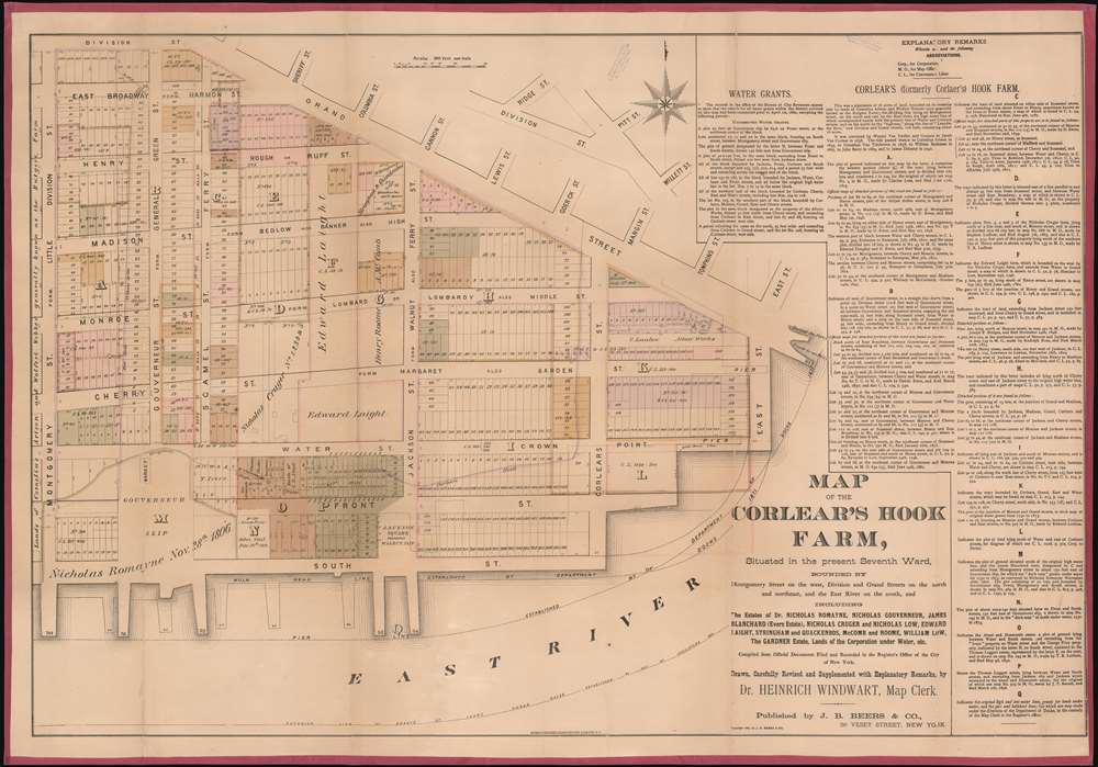
Map of the Corlear's Hook Farm, Situated in the present Seventh Ward…
1881 (dated) 24.5 x 36 in (62.23 x 91.44 cm) 1 : 1200
1881 (dated) 24.5 x 36 in (62.23 x 91.44 cm) 1 : 1200
Description
This is a rare 1881 Heinrich Windwart map of the New York City's Lower East Side, from Grand Street to the East River and from Montgomery to East Street, a region once known as the Corlear's Hook Farm. This is most likely the earliest specific published map of this part of New York. The meticulously compiled map illustrates multiple estates, including those of Nicholas Romayne, Nicholas Gouverneur, James Blanchard, Nicholas Cruger, Nicholas Low, Edward Laight, Stringham, Quackenbos, McComb, Roome, Willima Low, and the Gardner state. It illustrates the original waterline of Manhattan before the mid-19th century landfills. In addition, it shows underwater lands belonging to the Corporation of New York according to the legislative act of 1871.
The Lotting of Manhattan
In the early 19th century most of Manhattan was undeveloped farm lands, the property of wealthy landowners with claims dating to the Dutch period of New York's history. The northern two thirds of Manhattan was dotted with farmlands and sprawling gentlemanly estates, many with great manor houses overlooking the Hudson River. The Commissioners' Plan of 1811 and the 1807 Commission Law, laid the street grid through many of these properties and gave the city the right to claim these lands under eminent domain, providing due compensation to the landowners. While this work occurred early in lower Manhattan, central and upper Manhattan were not formally acquired by the city until the mid-19th century.Why These Maps were Made
Several entrepreneurial mapmakers, among them John Bute Holmes, Heinrich Windwart, Richard D. Cooke, and James Botsford Beers, became fascinated by the early history of Manhattan real estate ownership, recognizing the wealth to be accrued by accurately understanding the history of city land ownership, division, and inheritance. Many of these cartographers, especially Holmes, allied themselves with the corrupt Tweed administration, assuring even greater wealth and political power from the eminent domain seizure of old Manhattan estates. The cartographers created a series of maps, reminiscent of John Randall's 'Farm Maps', overlaid with property data, showing the borders of old estates, and notating the breakup of the lands among various heirs. The complex work of compiling the maps earned many of them a fortune. One newspaper writing of the Holmes estate after his 1887 death that some of the individual maps were worth more than 30,000 USD.Provenance
This map was acquired as a part of a large collection of New York cadastral maps associated with the layer Ronald K. Brown, a Deed Commissioner operating in the late 19th and early 20th century with an office at 76 Nassau Street, New York - not far from Holmes' own office. Most of the maps in the collection, including the present map, bear Brown's stamp on the verso. The maps were passed to Dominic Anthony Trotta, a real estate agent working under Brown. Brown seems to have ceased business around 1919, but Trotta continued as a real estate agent, becoming a New York Tax Commissioner in 1934 under the Fiorello H. La Guardia administration. The maps remained with Trotta's heirs until our acquisition of the collection.Publication History and Census
This map was laid out by the map clerk Heinrich Windwart and published in New York by James Botsford Beers. The engraving and printing is the work of Neuman and Dinglinger Lithography. This map is exceedingly rare. There are only tjree examples cited in the OCLC, at the University of Wisconsin, Stony Brook University, and the New York State Library. We are aware of a 3rd uncatalogued example at the New York Public Library.CartographerS
Heinrich Windwart (July 12, 1810 - April 30, 1881) was a German civil servant, revolutionary, medical doctor, and map publisher. He was born in Bavaria and studied at the University of Jena. He was heavily involved in the German Revolutions of 1848. When the revolutions were suppressed, he went into exile, first in Switzerland, then France, and ultimately, in 1853, to the United States. He initially settled in Baltimore, but moved to New York in the 1860s when his fellow German 'Forty-Eighter,' Franz Sigel (1824 - 1902), was elected Registrar of New York City, and offered him a clerk position. Windwart was one of several map publishers, the most famous of whom was John Bute Holmes, who was able to leverage cartographic skill to capitalize on the New York City transition from grand 18th century estates to the meticulously gridded and plotted structure of the Commissioner's Plan. More by this mapmaker...
James Botsford Beers (October 16, 1811 - June 3, 1901) was an American map publisher based in Connecticut in the second half of the 19th century. Beers was born in Newtown, Connecticut. He married Huldah Clarke (1813 - 1893) on August 30, 1835, in his hometown. They had five children in 18 years of marriage. He lived in Brooklyn, New York, from about 1845 where he dealt in jewelry and gold pens. Beers started publishing maps as 'J. B. Beers' in 1863, possibly inspired by the success of John Bute Holmes (1822 - 1887). In 1867, in partnership with A.D. Ellis and G.G. Soule, published his Atlas of New York and Vicinity. His son Frederick W. Beers joined the family business in 1870, at which point the firm was renamed 'J. B. Beers and Company'. Botsford Beers is the progenitor of the prolific Beers mapmaking family - who mostly published out of New York. He worked with his brother Charles Henry Beers (November 3, 1813 - March 5, 1892), son Frederick William Beers (August 17, 1839 - September 8, 1933), and grandsons Silas Norman Beers (September 3, 1837 - May 12, 1873) and Daniel Glover Beers (October 19, 1841 - February 12, 1913). Learn More...
Neuman and Dinglinger Lithography (fl. 1880 - 1882) was a New York City based lithography and engraving firm based at the Northwest corner of Pearl and Elm Streets, New York City. Little is known of their business. They published an important chronological chart of American history, as well as maps for James Botsford Beers (1811 - 1901) and John Bute Holmes (1822 - 1887). In addition to maps, they also produced stunning chromolithograph trade cards for the tobacco industry. Most of their work dates to the early 1880s. Learn More...
Condition
Very good. Professionally relined with fresh linen.
References
OCLC 50562210.