
1945 World War II Pictorial Unit Route Map of the 748th Field Artillery Bn. in Europe

This item has been sold.
History of 748 F. A. Bn. in E.T.O.
Follow the 748th Field Artillery Battalion through the European Theater of Operations.
Choose a Collection:
- Digital Map Information
- Suitable for large format printing
- File Size: 28.5 MB
- File Type: ZIP / TIFF
- ICC color profile embedded
- Delivered instantly via download link
This Item
Enquire
Follow the 748th Field Artillery Battalion through the European Theater of Operations.
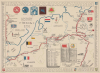
This is a rare 1945 World War II pictorial route map of the 748th Field Artillery Battalion in the European Theater of Operations. The map follows the battalion from Liverpool, England, to Weissenburg, Germany, and marks its battles and alongside illustrations of landmarks and 'cultural moments' experienced by the soldiers.A Closer Look
A bright red line highlights the 748th Field Artillery Battalion's movements across England, France, Belgium, and Germany. Trucks pulling artillery pieces appear all along the route. Numerous cities are labeled along the way, including Dieppe, Charleroi, Liege, Magdeburg, and Braunschweig. Explosions and artillery pieces mark battle locations. A list of Battalion Command Posts and a list of officers appear along the bottom border, and a banner names Lieutenant Colonel Harry E. Irons as the commanding officer. A roster of each of the battalion's five regiments creates the map's border.Illustrations
Numerous illustrations add character to this piece. The Houses of Parliament and a royal guard mark London, while the Eiffel Tower and the Arc de Triomphe identify Paris. National flags appear, along with familiar symbols like a wooden clog in Belgium and a windmill in Holland. 'Kaput' appears below the Nazi flag, and 'Results-Gratifying' is written next to the flag. Hitler's severed head is held aloft below the flag.Illustrations that are prevalent among maps in the genre make an appearance here as well. Among these are a French child asking the question 'cigarette pour Papa!', a German woman with 'Verboten!' (Forbidden) written next to her, a lone German plane referred to as 'Bed Check Charlie', and American and Soviet soldiers raising a glass along the Elbe. The German woman with 'Verboten!' appears because fraternizing with German women was strictly forbidden in the American ranks, which obviously didn't stop some GIs. 'Bed Check Charlie' refers to the almost nightly interruption of a single German aircraft over Allied positions to keep Allied soldiers awake, thus depriving them of much needed rest.
Following the 748th
The 748th Field Artillery Battalion began its war in Europe by arriving in Liverpool, England, in December 1944 and remained in England until it left for France in March 1945. The battalion arrived in Dieppe, France, and then traveled to Belgium before entering combat in Germany at the end of March. The battalion fought across Germany, even reaching as far north as the Baltic Sea, then returned south, fought past Leipzig and Nuremberg, and ended the war (at least as far as is illustrated here) in Weissenburg.Allied World War II Route Maps
Maps tracing unit movements during World War II were created by both American and British forces during and after the war. As a genre, these maps represent a broad range of aesthetics, from the purely functional that label places and provide dates, to the artistic, even comic. Many combine all three and provide a visually striking but historically informative summary of the unit's peregrinations.Publication History and Census
This map was drawn by an unknown artist (almost certainly a member of the 748th) and published in the European Theater of Operations in July 1945. We note 2 cataloged examples, which are part of the collections at Texas A and M University and the Controvich Library.Condition
Very good. Light toning and edge wear.
References
Texas A and M University G5721.S7 1945.H58.