This item has been sold, but you can get on the Waitlist to be notified if another example becomes available, or purchase a digital scan.
1945 Kaliher and White Pictorial WWII Route Map of the 79th Inf. in France
79Inf14Jun29Aug-white-1945$275.00

Title
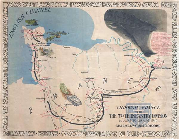
Through France with the 79th Infantry Division 14 June to 29 Aug, 1944. Maj Gen I.T. Wyche, Commanding.
1945 (undated) 26 x 33 in (66.04 x 83.82 cm) 1 : 390000
1945 (undated) 26 x 33 in (66.04 x 83.82 cm) 1 : 390000
Description
This is a 1945 Steve Kaliher and Harry D. White pictorial map of the 79th Infantry's route through northern France. The map depicts northern France from the English Channel south to Le Mans and from Mont Saint-Michel Bay to Mantes Gassicourt and the Seine River. Tracing the beginning of the 79th's combat in France, the map covers towns and cities from Normandy through the Ile-de-France just west of Paris. Black arrows follow the division's movements, with thin red lines illustrating how far the division moved from day to day. Several charming vignettes dot the map, including an illustration of the division landing in Normandy eight days after D-Day, the Fort du Roule in Cherbourg, and the swift advance (a tank followed by troops in a truck) after the Allies finally broke out of Normandy. A gloomy, dark vignette occupies the upper right corner illustrating the 79th's crossing of the Seine River at Mantes Gassicourt, the first Allied bridgehead across the Seine. The 79th played a critical role in this operation, securing the bridgehead on the east bank of the Seine.
This map was created by Steve Kaliher and Harry D. White and printed by Fritz Busche Druckereiges M.B.H. in Germany in 1945.
This map was created by Steve Kaliher and Harry D. White and printed by Fritz Busche Druckereiges M.B.H. in Germany in 1945.
Cartographer
Stephen Eugene Kaliher (1910 - October 19, 1969) was an American military officer, artist, and engineer. A native of Ohio, Kaliher was an engineer and surveyor by profession working as a civil engineer at a steel plant in Ohio in 1940. Kaliher enlisted in the U.S. Army in 1942 and served in the 79th Infantry Division, where he attained the rank of Master Sergeant. After the war, Kaliher founded the engineering firm Kohli and Kaliher Associates, Inc, a firm that he worked with until his death. Kaliher was married to Beata Kaliher with whom he had two children. More by this mapmaker...
Condition
Very good. Even overall toning. Slight loss in bottom right corner. Blank on verso.
References
Pritzker Military Museum and Library G5701.S7 1945.W34 1945b. Rumsey 8344.000. OCLC 50264160.