Digital Image: 1694 Burnet View of the Earth without Its Oceans, w/ California as an Island
Aardkloot-burnet-1694_d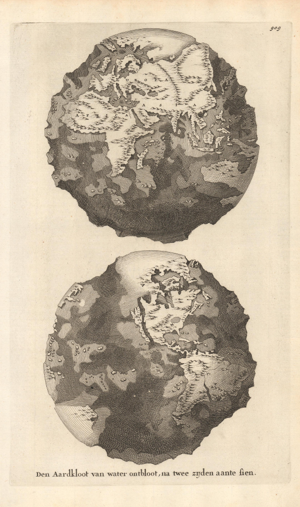

Title
Den Aardkloot van water ontbloot, na twee zijden aante sien.
1694 (undated) 12.25 x 7.25 in (31.115 x 18.415 cm)
1694 (undated) 12.25 x 7.25 in (31.115 x 18.415 cm)
Description
FOR THE ORIGINAL ANTIQUE MAP, WITH HISTORICAL ANALYSIS, CLICK HERE.
Digital Map Information
Geographicus maintains an archive of high-resolution rare map scans. We scan our maps at 300 DPI or higher, with newer images being 600 DPI, (either TIFF or JPEG, depending on when the scan was done) which is most cases in suitable for enlargement and printing.
Delivery
Once you purchase our digital scan service, you will receive a download link via email - usually within seconds. Digital orders are delivered as ZIP files, an industry standard file compression protocol that any computer should be able to unpack. Some of our files are very large, and can take some time to download. Most files are saved into your computer's 'Downloads' folder. All delivery is electronic. No physical product is shipped.
Credit and Scope of Use
You can use your digial image any way you want! Our digital images are unrestricted by copyright and can be used, modified, and published freely. The textual description that accompanies the original antique map is not included in the sale of digital images and remains protected by copyright. That said, we put significant care and effort into scanning and editing these maps, and we’d appreciate a credit when possible. Should you wish to credit us, please use the following credit line:
Courtesy of Geographicus Rare Antique Maps (https://www.geographicus.com).
How Large Can I Print?
In general, at 300 DPI, you should at least be able to double the size of the actual image, more so with our 600 DPI images. So, if the original was 10 x 12 inches, you can print at 20 x 24 inches, without quality loss. If your display requirements can accommodate some loss in image quality, you can make it even larger. That being said, no quality of scan will allow you to blow up at 10 x 12 inch map to wall size without significant quality loss. For more information, it is best consult a printer or reprographics specialist.
Refunds
If the high resolution image you ordered is unavailable, we will fully refund your purchase. Otherwise, digital images scans are a service, not a tangible product, and cannot be returned or refunded once the download link is used.
Cartographer S
Thomas Burnet (c. 1635 - September 27, 1715) was an English theologian and philosopher, particularly in the field of cosmogony, that is, the study of the origin of the universe (in this case from a Christian perspective). Burnet was born in Croft near Darlington in 1635 and attended Northallerton Grammar School, where he studied under Thomas Smelt. In 1651, he began studies at Cambridge, being a member of Clare College before shifting to Christ's College to follow the Master of Clare College, Ralph Cudworth, when he moved to Christ's College. He also studied under John Tillotson, the Archbishop of Canterbury, while at Cambridge. By 1658, he had become a fellow of Christ's College and earned a Master's degree, and in 1667, he was made a proctor of the college. Burnet worked for several noble British families, including as a tutor to Lord Ossory, grandson of James Butler, 1st Duke of Ormonde, who aided his appointment in 1685 as Master of the Charterhouse, an educational and charitable institution in London, a position he held until his death in 1715. In the wake of the Glorious Revolution, Burnet also served as chaplain in ordinary and Clerk of the Closet to William III (William of Orange). Burnet's scholarly output dealt with major metaphysical questions such as the origin of the universe and the nature of the soul from a Christian and proto-scientific standpoint. His best-known work is the Sacred Theory of the Earth, initially published in Latin as Telluris Theoria Sacra in the mid-late 1680s. Though firmly rooted in orthodox Christian theology concerning the Flood, Eden, and Genesis, Burnet expressed an early form of the conception of God as a master clockmaker, which became prevalent in the Victorian era more than a century later. Among the thinkers that Burnet influenced were Isaac Newton and Samuel Coleridge Taylor. Some of Burnet's ideas were unconventional and controversial at the time, to the point that he had to resign from his positions at the court of William III after publishing his 1692 book The Ancient Doctrine Concerning the Origin of Things (Archaeologiae Philosophicae sive Doctrina Antiqua de Rerum Originibus). More by this mapmaker...
Jan Goeree (1670 - 1731) was a Dutch painter, draughtsman and printmaker. He was also known as a poet. He was the son of one Willem Goeree and no details come down to us of his youth in Middleburg. In Amsterdam he was a pupil of Dutch Golden Age painter and art theorist Gerard de Lairesse. He lived out his life in Amsterdam, the city in which most of his work was produced. His engraving appeared in De Fer's Atlas Royal. Tooley's Dictionary is probably mistaken in saying he worked for Pieter van der Aa. Although his imprint is to be found on van der Aa's large format maps, these were executed on behalf of François Halma as early as 1694, and the plates later acquired and reprinted by van der Aa in 1713. Learn More...
Source
Voor-Bereidselen Tot de Bybelsche Wysheid en Gebruik der Heilige en Kerkelijke Historien, Vol. 2, (Amsterdam: Goeree) 1690-1700.
References
Burden, P., The Mapping of North America, 533.