This item has been sold, but you can get on the Waitlist to be notified if another example becomes available, or purchase a digital scan.
1799 Clement Cruttwell Map of Africa
Africa-cruttwell-1799$200.00

Title
Africa.
1799 (dated) 14 x 15.5 in (35.56 x 39.37 cm)
1799 (dated) 14 x 15.5 in (35.56 x 39.37 cm)
Description
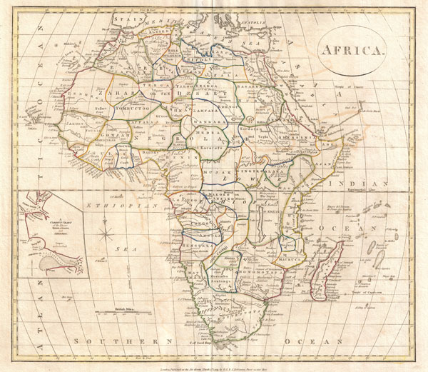
A fine 1799 map of Africa by the English map publisher Clement Cruttwell. Covers the entire region, including a detailed inset of the rivers of Sierra Leone and Sherbro (labeled 'A correct chart of the Rivers Sierra Leone and Sherbro.') Of note is the way Cruttwell carefully labeled the interior of Africa; at this point in the time it was only the coastal regions of the continent that had been explored in any extent. Cruttwell, however, notes each African Kingdom and tribe thought to exist throughout the continent. In central Africa, for instance, one can find the Jages, who are defined as Antrhopophages or cannibals. Many of Cruttwell's ideas and mappings of the interior of Africa proved to be misguided or completely wrong. The path of the White Nile, for instance, is incorrect and follows the conjecture laid down by Coronelli nearly 300 years earlier. What Cruttwell labels as Lake of Zambre is most likely an embryonic mapping Lake Malawi.
Cruttwell also makes note of the 'Hottentots' in South Africa. The 'Hottentots' were actually what some Europeans called the Khoikhoi ('people people' or 'real people') or Khoi. (The term 'Hottentot,' an imitation of the sound of the Khoisan languages, is considered derogatory today.) The Khoi are the native people of southwestern Africa, and are closely related to the Bushmen.
Outline color and fine copper plate engraving in the minimalist English style prevalent in the late 18th and early 19th centuries. Mountains and other topographical detail shown by profile. Drawn by G. G. and J. Robinson of Paternoster Row, London, for Clement Cruttwell's 1799 Atlas to Cruttwell's Gazetteer.
Cartographer
Clement Cruttwell (1743 - August 5, 1808) was an English book and map publisher active in Bath and London in the late 18th and early 19th century. Cruttwell was born the son of William Cruttwell, a gentleman of Wokingham, Berkshire, England. As a young man Cruttwell was educated to be an Anglican Reverend and consequently maintained a lifelong interest in religious matters. Throughout his life, he published a number of religious works and geographical gazetteers including several focused on the British Isles and one dedicated to France. Though little is known of Cruttwell today, he was highly regarded in his own time. In his obituary, a period publication, The Universal Magazine of Knowledge and Pleasure describes Cruttwell as
a gentleman whose various literary performances, for labour, extent, and utility, have rarely been equaled, and, when regarded as the productions of an unassisted valetudinarian, have perhaps never been surpassed.Cruttwell was also a known correspondent of George Washington to whom he sent his own translation of the Holy Bible, which Washington kept in his personal library until his death. More by this mapmaker...
Source
Cruttwell, C., Atlas to Cruttwell's Gazetteer, 1799.
Condition
Very good. Original centerfold. Platemark visible. Some offsetting. Moderate overall toning. Blank on verso.