1851 Black Map of North and South Africa
AfricaNorthSouth-black-1851$150.00

Title
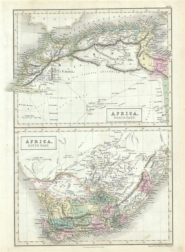
Africa, North Part. Africa, South Part.
1851 (undated) 16 x 11.5 in (40.64 x 29.21 cm)
1851 (undated) 16 x 11.5 in (40.64 x 29.21 cm)
Description
This is a fine example of Adam and Charles Black's 1851 map of Africa, northern and southern parts. Divided into two parts, the upper map is of the Barbary Coast and covers the western Mediterranean Coast of Africa from Morocco to Tripoli, including modern day Morocco, Algeria, Tunisia and Libya. The lower map covers modern day South Africa and includes the cities and towns of Clanwilliam, Beaufort, Worchester, Cape Town, George, Uitenhage, Stellenbosch, Somerset and Graaff-Reinet. The map of North Africa depicts the Tuat, a vast desert region, marked with numerous oases. The desert area is largely unmapped, simply identified as 'A dry Country abounding in Dates.' The map of South Africa depicts the regions of the various Bushmen (Bosjesmans) tribes. The 'Orange River Sovereignty,' which existed ephemerally from 1848 to 1854 between the Orange and Vaal Rivers, is identified. Various cities, towns, oases, rivers, deserts, mountains and several other topographical details are marked with relief shown in hachures. This map was engraved by Sidney Hall and issued as plate no. XLIV in the 1851 edition of Black's General Atlas of the World.
CartographerS
Charles and Adam Black (fl. 1807 - present) were map and book publishers based in Edinburgh. Charles and his uncle, Adam, both of Edinburgh, Scotland, founded their publishing firm in 1807. They published a series of maps and atlases throughout the 19th century. In addition to an array of atlases, the Black firm is known for their editions of the Encyclopedia Britannica (1817 - 1826) and the first publishing of Sir Walter Scott's novels in 1854. In 1889 the A. & C. Black publishing house moved to London where it remains in operation to this day. More by this mapmaker...
Sidney Hall (1788 - 1831) was an English engraver and map publisher active in London during the late 18th and early 19th centuries. His earliest imprints, dating to about 1814, suggest a partnership with Michael Thomson, another prominent English map engraver. Hall engraved for most of the prominent London map publishers of his day, including Aaron Arrowsmith, William Faden, William Harwood, and John Thomson, among others. Hall is credited as being one of the earliest adopters of steel plate engraving, a technique that allowed for finer detail and larger print runs due to the exceptional hardness of the medium. Upon his early death - he was only in his 40s - Hall's business was inherited by his wife, Selina Hall, who continued to publish under the imprint, "S. Hall", presumably for continuity. The business eventually passed to Sidney and Selina's nephew Edward Weller, who became extremely prominent in his own right. Learn More...
Source
Black, A. and C., General Atlas Of The World, (Edinburgh) 1851.
Condition
Very good. Minor overall toning. Blank on verso.
References
Rumsey 2305.050 (1854 edition). Philips (atlases) 4334.