This item has been sold, but you can get on the Waitlist to be notified if another example becomes available, or purchase a digital scan.
1783 Vaugondy Map of Africa
Afrique-vaugondy-1757$200.00

Title
L'Afrique dressee, sur les relations les plus recentes, et assujettie aux observations astronomiques.
1783 (dated) 19 x 24 in (48.26 x 60.96 cm) 1 : 20000000
1783 (dated) 19 x 24 in (48.26 x 60.96 cm) 1 : 20000000
Description
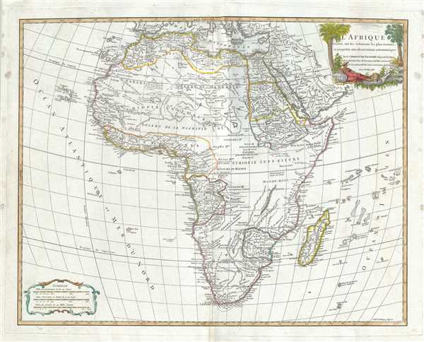
This is an exceptional 1783 map of Africa by Robert de Vaugondy. Following on the work of Nicolas Sanson, Vaugondy's map of Africa covers the entire continent in considerable detail. The late 18th century saw little in the way of African Exploration, so other than some minor updates to South Africa, this issue, remains consistent with the map originally published by Robert de Vaugondy in 1749.
Like most maps of Africa from this period, the whole is rife with speculation. Vaugondy, unlike many of his contemporaries, attempts to limit his geographical analysis of the continent to those areas reported on in relatively recent times. Thus the White Nile, rather than turn east to meet with the Niger or flow south into the Ptolemaic Mountains of the Moon, merely tapers off into the unknown. Central Africa is largely left blank, although appears to be divided into several little known kingdoms: Monoe-mugi, Mujac, Gingir-Bomba, and Macoco, among others. The Sultanate of Zanzibar is given control of much of Eastern Africa from the Horn to the Zambesee River. Lake Malawi appears in recognizable but embryonic form with it supper terminus left unmapped and thus unknown. In West Africa the known kingdoms of Benin and Congo are mapped according to the early 18th century conventions. South Africa exhibits updated information associated with mid-18th century discoveries.
A highly decorative title cartouche appears in the top right quadrant. Drawn by Robert de Vaugondy and published in his Atlas Universal. The Atlas Universal was one of the first atlases based upon actual surveys. Therefore, this map is highly accurate (for the period) and has most contemporary town names correct, though historic names are, in many cases, incorrect or omitted.
Cartographer
Robert de Vaugondy (fl. c. 1716 - 1786) was French may publishing from run by brothers Gilles (1688 - 1766) and Didier (c. 1723 - 1786) Robert de Vaugondy. They were map publishers, engravers, and cartographers active in Paris during the mid-18th century. The father and son team were the inheritors to the important Nicolas Sanson (1600 - 1667) cartographic firm whose stock supplied much of their initial material. Graduating from Sanson's maps, Gilles, and more particularly Didier, began to produce their own substantial corpus. The Vaugondys were well-respected for the detail and accuracy of their maps, for which they capitalized on the resources of 18th-century Paris to compile the most accurate and fantasy-free maps possible. The Vaugondys compiled each map based on their own geographic knowledge, scholarly research, journals of contemporary explorers and missionaries, and direct astronomical observation. Moreover, unlike many cartographers of this period, they took pains to reference their sources. Nevertheless, even in 18th-century Paris, geographical knowledge was limited - especially regarding those unexplored portions of the world, including the poles, the Pacific Northwest of America, and the interiors of Africa, Australia, and South America. In these areas, the Vaugondys, like their rivals De L'Isle and Buache, must be considered speculative or positivist geographers. Speculative geography was a genre of mapmaking that evolved in Europe, particularly Paris, in the middle to late 18th century. Cartographers in this genre would fill in unknown lands with theories based on their knowledge of cartography, personal geographical theories, and often dubious primary source material gathered by explorers. This approach, which attempted to use the known to validate the unknown, naturally engendered rivalries. Vaugondy's feuds with other cartographers, most specifically Phillipe Buache, resulted in numerous conflicting papers presented before the Academie des Sciences, of which both were members. The era of speculative cartography effectively ended with the late 18th-century explorations of Captain Cook, Jean Francois de Galaup de La Perouse, and George Vancouver. After Didier died, his maps were acquired by Jean-Baptiste Fortin, who in 1787 sold them to Charles-François Delamarche (1740 - 1817). While Delamarche prospered from the Vaugondy maps, he defrauded Vaugondy's window Marie Louise Rosalie Dangy of her rightful inheritance and may even have killed her. More by this mapmaker...
Source
Robert de Vaugondy, G., Atlas Universel, (Paris: Antoine Boudet) 1757.
The Atlas Universel was the crowning glory of the Robert de Vaugondy firm's atlas production. The atlas was revolutionary on many levels and exemplified the Vaugondy credo commode, complet, univorme, et suive (convenient, complete, uniform, and easy to use). The atlas thus consisted of a wide corpus of maps, both modern and historical, was of moderate height and width, and featured maps of uniform style and structure. They partnered with Antoine Boudet, a shrewd businessman and publisher with whom they had worked previously, to produce the 1752 first edition. To minimize his fiscal risk, Boudet sold the atlas first by subscription using a large prospectus, receiving in the process over 1100 pre-orders. The first edition appeared in 1752 and contained beautifully produced maps with elaborate freshly designed allegorical cartouche work, generally by Pierre-Edme Babel, Pierre Philippe Choffard, and Charles Nicholas Cochin. Most of the maps were engraved by the Delahaye firm, the payment for whose services ultimately led to legal disputes. Despite proving a popular work of astounding quality, the Atlas Universal received harsh criticism from fellow cartographers, particularly Philipppe Buache. Ever at odds with the Vaugondys, Buache's critical perspective may have been influenced more by political maneuvering than academic affront. The atlas was issued in multiple editions between 1752 and 1788. Later editions, issued after 1786, were taken over by Charles Delamarche, who inherited the Robert de Vaugondy firm and assumed Boudet's publication rights.
Condition
Very good. Minor wear along original centerfold. Original platemark visible. Some spotting and offsetting with water stains near borders. Faded text in northwest Africa.
References
Rumsey 3353.096. Pedley, Mary Sponberg Belle et Utile: The Work of the Robert de Vaugondy Family of Mapmakers, 426.