1827 Vandermaelan Map of the Aleutian Islands, Alaska
AleutianIslands-vandermaelen-1827$1,200.00

Title
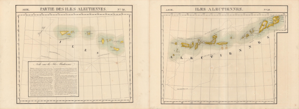
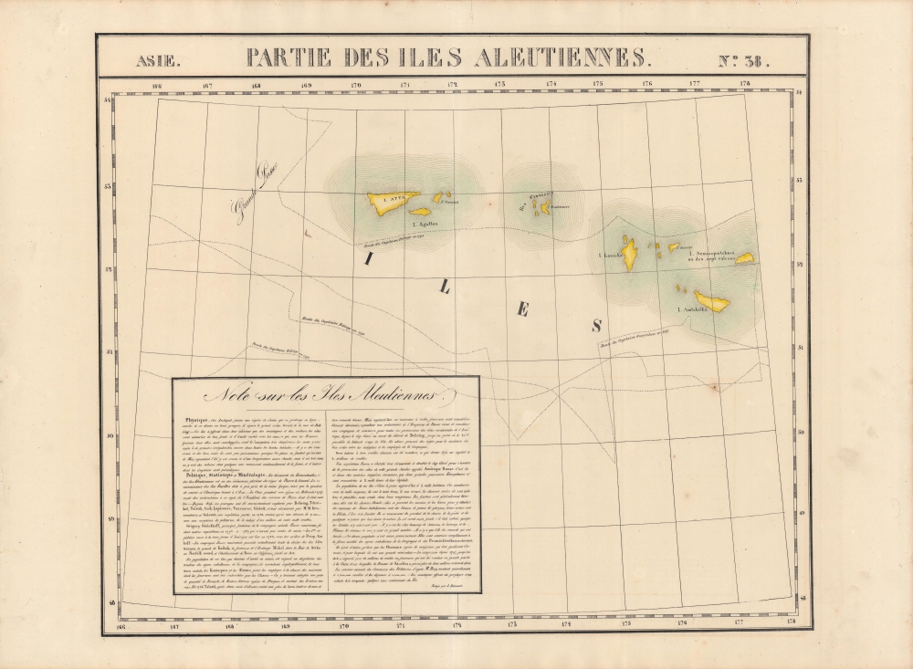
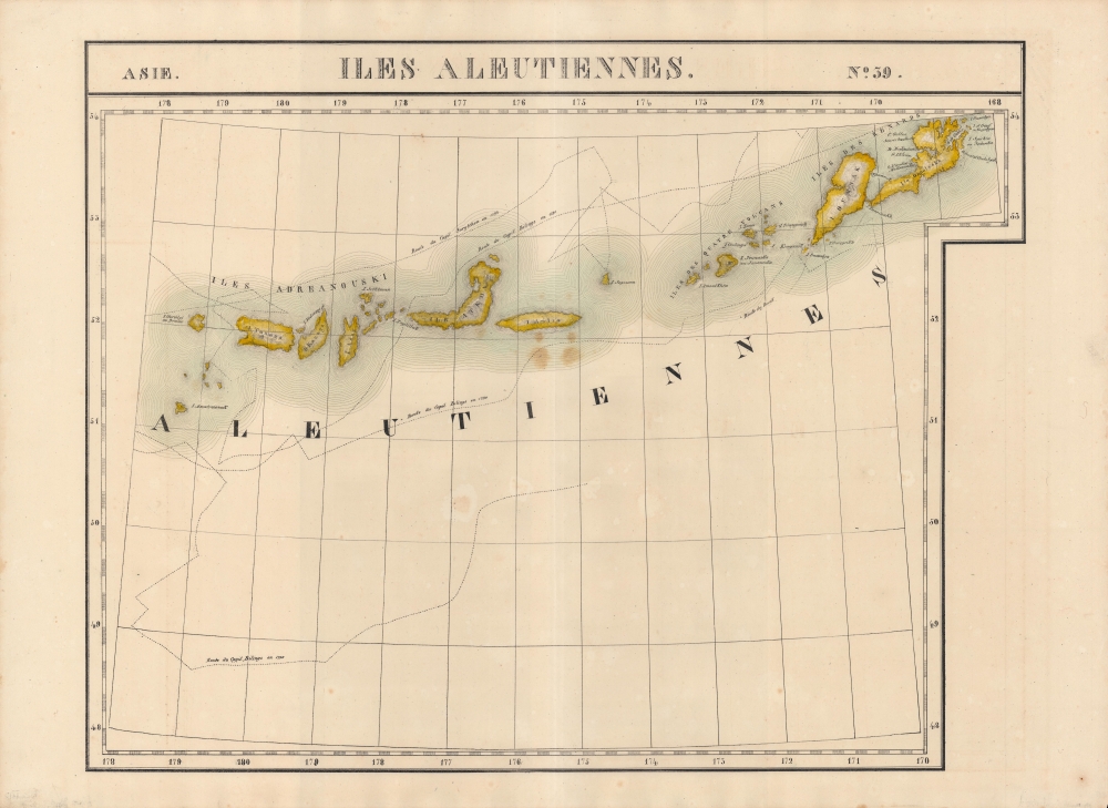
Partie des Iles Aleutiennes. Asie 38 / Iles Aleutiennes. Asie 39.
1827 (undated) 21 x 57 in (53.34 x 144.78 cm) 1 : 1641836
1827 (undated) 21 x 57 in (53.34 x 144.78 cm) 1 : 1641836
Description
An 1827 Phillipe Vandermaelen map of the Aleutian Islands, considered the earliest lithographed map of the islands. Vandermaelen's Atlas Universel was the first lithograph atlas as well as the first whose maps were printed on a universal scale.
Although never numbering more than 700, the Russians did establish a settlement at Novo-Arkhangelsk (now Sitka) as well as outposts as far south as the coast of California and Hawaii. They had a major impact on the native inhabitants of the Aleutians and mainland Alaska, with some 80 percent of the indigenous population dying from disease within two generations, not to mention those killed in violent conflict. The environmental effects were similarly severe, as the population of animals hunted for their furs (especially seals and otters) declined dramatically, becoming a major source of tension with indigenous Alaskans.
In the end, the colony was relatively costly to maintain, as well as being not especially profitable due to the distances involved and the general reduction of the furrieries. By the 1860s, the Russians expected the Americans, British, or some other power to try to grab Alaska and preferred that it not go to their great rival Britain, which they feared could use Canada as a base to encroach on Siberia. The Tsar was also desperate for money to pay for Russia's costly loss in the Crimean War (1853 - 1856). It therefore made sense to sell Russia's American colony to the United States in 1867.
A Closer Look
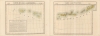
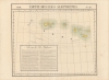
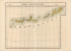
The Aleutians are displayed stretching from Unalaska (Onnalaska) Island in the east to Attu (Atta) Island in the west, with mountains, bays, other coastal features, and islets indicated. A textbox at bottom-left provides information on the physical geography of the islands, as well as their history, including exploration by Europeans, such as Vancouver, La Perouse, and Behring, some of which are tracked on the map. Vandermaelen also includes data about the islands' population and their administration as part of Russian America, still a relatively recent development at the time.Russian America
Russian interest in America was largely the result of two processes - Russian expansion into Siberia and maritime exploration of the Arctic and Pacific. As in Siberia, Russia had a distinct economic interest in harvesting natural resources from Alaska, namely furs. In 1799, Tsar Paul I issued a decree (Ukase) that claimed lands north of the 55th parallel and gave exclusive privileges to the Russian-American Company (an outgrowth of the pre-existing United-American Company or Shelikhov-Golikov Company).Although never numbering more than 700, the Russians did establish a settlement at Novo-Arkhangelsk (now Sitka) as well as outposts as far south as the coast of California and Hawaii. They had a major impact on the native inhabitants of the Aleutians and mainland Alaska, with some 80 percent of the indigenous population dying from disease within two generations, not to mention those killed in violent conflict. The environmental effects were similarly severe, as the population of animals hunted for their furs (especially seals and otters) declined dramatically, becoming a major source of tension with indigenous Alaskans.
In the end, the colony was relatively costly to maintain, as well as being not especially profitable due to the distances involved and the general reduction of the furrieries. By the 1860s, the Russians expected the Americans, British, or some other power to try to grab Alaska and preferred that it not go to their great rival Britain, which they feared could use Canada as a base to encroach on Siberia. The Tsar was also desperate for money to pay for Russia's costly loss in the Crimean War (1853 - 1856). It therefore made sense to sell Russia's American colony to the United States in 1867.
Publication History and Census
This map appeared in two sheets as maps No 38 and 39 in the second volume, 'Asie,' of Vandermaelen's Atlas universel de géographie physique, politique, statistique et minéralogique. Each sheet measures 21 inches tall and 28.5 inches wide; together they are 57 inches wide. The atlas was produced in one edition in 1827, with only 810 complete sets sold. The full set of six volumes appears in eleven institutional collections in OCLC, and the second volume alone is listed in 14, but the map is not independently cataloged.Cartographer
Philippe Marie Guillaume Vandermaelen (December 23, 1795 - May 29, 1869) was a Flemish cartographer active in Brussels during the first part of the 19th century. Vandermaelen is created with "one of the most remarkable developments of private enterprise in cartography," namely his remarkable six volume Atlas Universel de Geographie. Vandermaelen was born in Brussels in 1795 and trained as a globe maker. It was no doubt his training as a globe maker that led him see the need for an atlas rendered on a universal scale in order that all bodies could be understood in relation to one another. In addition to his great work Vandermaelen also produced a number of globes, lesser maps, a highly detailed 250 sheet map of Belgium, and several regional atlases. More by this mapmaker...
Source
Vandermaelen, P., Atlas universel de geographie physique, politique, statistique et mineralogique, (Bruxelles: Vandermaelen) 1827.
Atlas Universel de Geographie. This great work, featuring some 378 unique maps and compiled over three years, was the first lithograph atlas, and the first to render the world on the same projection and at a uniform scale. It was no doubt Vandermaelen’s training a globe maker that led him see the need for an atlas rendered uniformly so that all bodies could be understood in relation to one another. As a result, many newly emerging areas received more attention than prior efforts. Maps of the American West, in particular, benefited: ‘no mapmaker had previously attempted to use such a large scale for any western American area.’ (Wheat). Central and South Asia also appear in sharper focus. Despite Vandermaelen’s reliance upon existing sources, his maps very frequently provided the clearest depictions available of many poorly-understood parts of the world. The atlas was an expensive production, costing $800 in 1827. Subscription lists indicate that only 810 full sets of the atlas were sold. It was printed on high-quality paper with superior hand coloring and was engraved in a clear, legible style. Conjoined, the maps of Vendermaelen's atlas would create a massive globe some 7.75 meters in diameter, a feat which was accomplished at the Etablissement Geographique de Brussels.
Condition
Very good. Some marginal staining and sporadic foxing.
References
Rumsey 2212.070, 2212.071.