Digital Image: 1858 H. V. Poor Railroad Map of the Eastern United States
AllRailRoads-poor-1858_d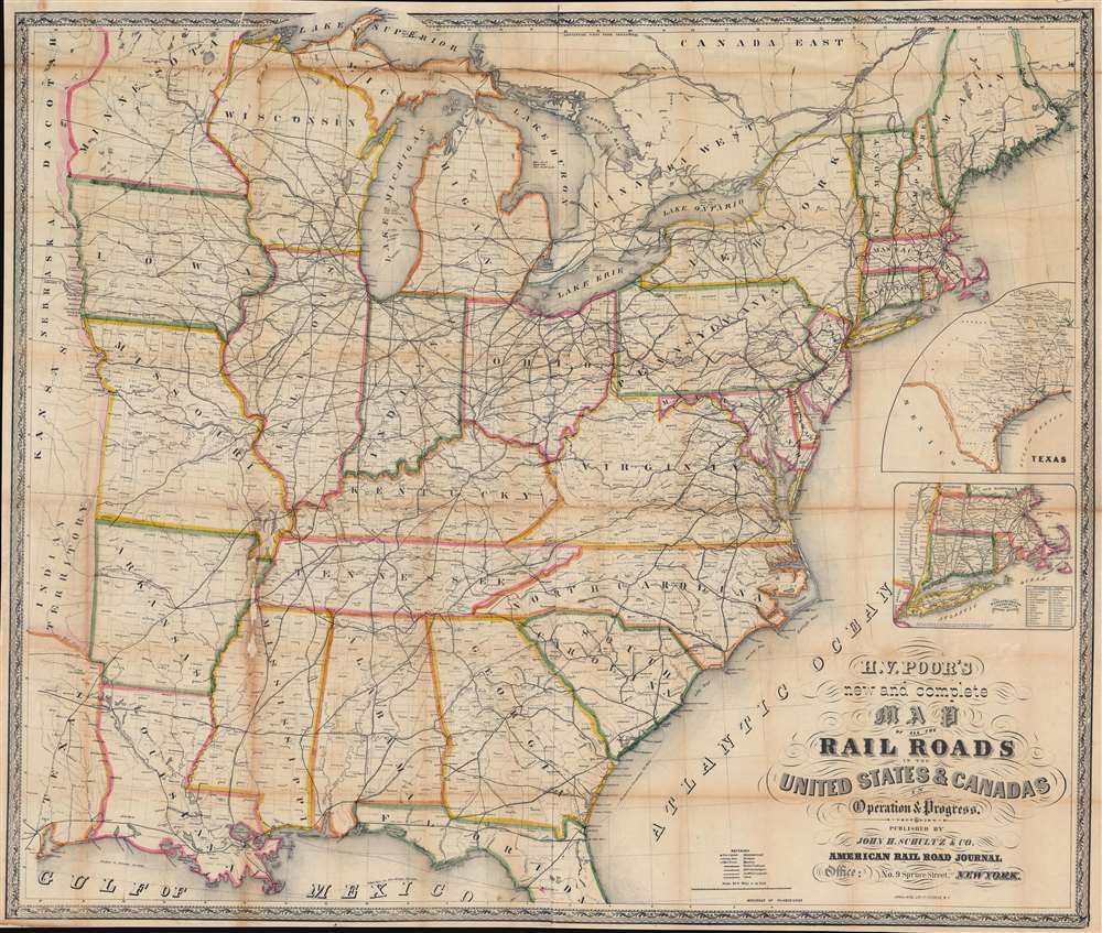

Title
H. V. Poor's new and complete Map of All the Rail Roads in the United States and Canadas in Operation and Progress.
1858 (undated) 37 x 43.5 in (93.98 x 110.49 cm) 1 : 2112000
1858 (undated) 37 x 43.5 in (93.98 x 110.49 cm) 1 : 2112000
Description
FOR THE ORIGINAL ANTIQUE MAP, WITH HISTORICAL ANALYSIS, CLICK HERE.
Digital Map Information
Geographicus maintains an archive of high-resolution rare map scans. We scan our maps at 300 DPI or higher, with newer images being 600 DPI, (either TIFF or JPEG, depending on when the scan was done) which is most cases in suitable for enlargement and printing.
Delivery
Once you purchase our digital scan service, you will receive a download link via email - usually within seconds. Digital orders are delivered as ZIP files, an industry standard file compression protocol that any computer should be able to unpack. Some of our files are very large, and can take some time to download. Most files are saved into your computer's 'Downloads' folder. All delivery is electronic. No physical product is shipped.
Credit and Scope of Use
You can use your digial image any way you want! Our digital images are unrestricted by copyright and can be used, modified, and published freely. The textual description that accompanies the original antique map is not included in the sale of digital images and remains protected by copyright. That said, we put significant care and effort into scanning and editing these maps, and we’d appreciate a credit when possible. Should you wish to credit us, please use the following credit line:
Courtesy of Geographicus Rare Antique Maps (https://www.geographicus.com).
How Large Can I Print?
In general, at 300 DPI, you should at least be able to double the size of the actual image, more so with our 600 DPI images. So, if the original was 10 x 12 inches, you can print at 20 x 24 inches, without quality loss. If your display requirements can accommodate some loss in image quality, you can make it even larger. That being said, no quality of scan will allow you to blow up at 10 x 12 inch map to wall size without significant quality loss. For more information, it is best consult a printer or reprographics specialist.
Refunds
If the high resolution image you ordered is unavailable, we will fully refund your purchase. Otherwise, digital images scans are a service, not a tangible product, and cannot be returned or refunded once the download link is used.
Cartographer S
Henry Varnum Poor (December 8, 1812 - January 4, 1905) was an American financial analyst who founded H. V. and H. W. Poor Co., a company that eventually evolved into Standard and Poor's, a bellwether of the financial research and analysis industry. Poor was born in Andover, Maine, and was the first in his family to graduate from college, receiving a degree from Bowdoin in 1835. After graduation he joined his uncle's law firm and based the bar in 1838. Henry and his brother John Poor established a law practice a few years later in Bangor, Maine. The Poor brothers made a fortune investing in Maine's timber industry, and John became a minor railway magnate. He was also heavily involved in building the Maine railroad network. John purchased the American Railroad Journal in 1849 and Henry became the editor and manager. To compile comprehensive information about the operational and financial state of railroad companies around the United States, Henry Poor published History of Railroads and Canals in the United States in 1860. After he started the H. V. and H. W. Poor Company with his son Henry William, Poor published annual editions of his book. Poor was appointed a government commissioner to the Union Pacific Railroad in 1862, which caused him to leave his position as editor of the American Railway Journal. He was elected the Union Pacific's first Secretary later in 1862 but left the railroad not long afterward. Henry Poor was also a co-founder of the American Geographical Society. More by this mapmaker...
Lang and Laing (fl. 1861 – August 16, 1862) were New York City based publishers and lithographers active in the middle part of the 19th century. The firm was founded by founded by William Lang and Joseph Laing and maintained offices at 117 Fulton Street, New York City. They specialized in transferring copper and steel plates to lithographic stone for more economical printing. Their most significant cartographic work is the Jacob de Cordova and Robert Creuzbaur map of Texas. The firm was dissolved in August of 1862. Lang went on to partered with Henry Pooley Cooper, and continued to publish under the Lang and Cooper imprint until 1864. Learn More...
References
OCLC 862812633.