1770 Jefferys Map of Amelia Island, Florida
AmeliaIslandFlorida-jefferys-1770$4,000.00

Title
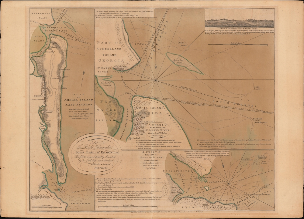
Plan of Amelia Island In East Florida. / A Chart of The Entrance Into St. Mary's River. / A Chart of The Mouth of Nassau Rivers. / To the Right Honourable John Earl of Egmont, and c. This Plate is most humbly Inscribed by his Lordships most Obedient Humble Servant Willm. Fuller.
1770 (dated) 21 x 25 in (53.34 x 63.5 cm)
1770 (dated) 21 x 25 in (53.34 x 63.5 cm)
Description
This is Thomas Jeffery's 1770 map of Amelia Island, considered the first specific published chart of that part of British East Florida. The map is based upon the William Gerard De Brahm and William Fuller surveys, which followed shortly after the 1763 British takeover of Florida. It illustrates the significance of Amelia's natural deep-water harbor, long a haunt of pirates, slavers, and smugglers, and details British attempts by John Perceval, 2nd Earl of Egmont, to establish a plantation colony.
The second map, both in terms of size and significance, appears at left and covers all of Amelia Island and parts of Talbot Island, the entrance to the Nassau River, and southern Cumberland Island. It is derived from the seminal 1757 John William Gerard De Brahm (1717 - 1798) mapping of the South Carolina coast. Although it overlaps somewhat with the more specific map below, it offers a valuable general reconnaissance.
The third map, appearing in the lower right, focuses on the western part of Amelia Island, Talbot Island, and the entrance to the Nassau River - an important artery for navigators. The map, derived from the 1769 work of Captain William Fuller, features numerous soundings and details of significance to the mariner.
A Closer Look
The map combines three charts. The main chart, occupying the upper right two-thirds of the sheet, covers the northern part of Amelia Island as well as the southern part of Cumberland Island, where the ruins of Oglethorpe's Fort William are noted. The fledgling settlement of Egmont Town and Morris's Bluff is laid roughly where the old Spanish fort of San Carlos once stood and where Fernandina Old Town stands today. In the upper right, there is a profile view of the St. Mary's River entrance.The second map, both in terms of size and significance, appears at left and covers all of Amelia Island and parts of Talbot Island, the entrance to the Nassau River, and southern Cumberland Island. It is derived from the seminal 1757 John William Gerard De Brahm (1717 - 1798) mapping of the South Carolina coast. Although it overlaps somewhat with the more specific map below, it offers a valuable general reconnaissance.
The third map, appearing in the lower right, focuses on the western part of Amelia Island, Talbot Island, and the entrance to the Nassau River - an important artery for navigators. The map, derived from the 1769 work of Captain William Fuller, features numerous soundings and details of significance to the mariner.
Dedication: Earl of Egmont
John Perceval, 2nd Earl of Egmont, received an expansive grant on Amelia Island in 1763 when Spain ceded Florida to England in exchange for Havana, which had been seized one year earlier in 1762, during the Seven Years' War (1756 - 1763). The grant, encompassing some 10,000 acres (the entire island), was ideally suited for cultivating cotton and indigo. Egmont was famous in England for his nostalgia for the 'feudal world' (Bailyn 1986:79) and amassed colonial holdings worldwide that he never visited, as here. His Amelia Island plantations flourished under the supervision of the experienced planter Stephen Egan. When Egmont died in 1770, the plantation continued to be managed by his widow, Catherine Perceval (1731-1784), the Dowager Earless and Baroness Arden. During the American Revolutionary War, the lucrative estate was plundered and destroyed by the Georgia Militia, causing Egan to flee with his family and the Egmont enslaved people.Publication History and Census
This map was drawn and published by Thomas Jefferys on March 26, 1770. The OCLC notes holdings of the chart in roughly 9 institutions. Scarce to the market. The map later served as the basis for subsequent maps by Sartine, Le Rouge, Laurie and Whittle, and others.CartographerS
Thomas Jefferys (1695 - November 20, 1771) was one of the most prominent and prolific map publishers and engravers of his day. Jefferys was born in Birmingham and was apprenticed to the engraver Emmanuel Bowen in 1735. Later, in the 1740s he engraved several maps for the popular periodical Gentleman's Magazine. Around 1740 Jefferys was finally able to go into business for himself and in 1746 received an appointment as 'Geographer to Fredrick, Prince of Wales,' which shortly after translated to the position of 'Royal Cartographer to King George III.' Jefferys initially specialized in compiling and re-engraving the works of earlier cartographers into more coherent cartographic wholes. Later, while not salaried position, Jefferys' appointment as 'Royal Cartographer' guaranteed preferential access to the most up to date cartographic material available, allowing him to produce new and updated charts of exceptional accuracy. He his best known for his maps of the Americas, particularly the posthumously published 1775 American Atlas, which included some of the finest and most important late colonial era maps of America ever made. Despite his prolific publishing history, royal appointments, and international publishing fame, Jefferys lived most of his life in dire economic straits. He was bailed out of bankruptcy by Robert Sayer during the production of the American Atlas. In the end, Jefferys died suddenly with very little to his name. Nonetheless, his cartographic legacy survived, and even after his death in 1771, many of his important maps continued to be published and republished by Sayer and Bennet, Conrad Lotter, Georges Louis Le Rouge, Laurie and Whittle, and others. Many attribute some of Jefferys best maps to the colorful and criminally inclined Irish cartographic genius Braddock Mead (John Green, c. 1688 - 1757), who is considered the 'secret behind Jefferys.' Jefferys was succeeded by his son, also Thomas, who had little success as a cartographer and eventually partnered with, then sold his stock and plates to William Faden - Jefferys' true heir. More by this mapmaker...
John William Gerard de Brahm (August 20, 1718 - June 6, 1799) was a German cartographer, hydrographer, engineer, and mystic. De Brahm was born in Koblenz, Germany, the son of Johann Phillip von Brahm, a court musician for the Elector of Trier. He studied engineering in Germany, reaching the rank of Captain Engineer in the Imperial Army of Holy Roman Emperor Charles VII. He resigned this commission in 1748 and shortly thereafter married, at the same time renouncing Catholicism in favor of Luthernism. After his marriage, he led a group of German immigrants to Georgia, then a British Colony, to settle in the German-Lutheran community of Ebenezer. In 1854 he became the Surveyor General of the Georgia Colony, a position he held until 1764. Druing this time, he produced his most important published work, A Map of South Carolina and a Part of Georgia. Afterwards he became Surveyor General for East Florida and the Southern District. In this and subsequent posts he traveled from Florida to Virginia, making a series of detailed maps, many of which survive only in manuscript. In his travels, de Brahm developed close relationships with American Indians whose traditional ways he deeply respected. This led him to become a fervent opponent to not only European colonialism, but also attempts to 'civilize' indigenous populations. During the American Revolutionary War (1775 - 1783) he was imprisoned in Charleston as a British Loyalist. By 1778 de Brahm was in Britain. In 1784, after the War, he returned to America settling in Philadelphia, where he died 12 years later. At some point he became an adherent to the teaching of the heretical German mystic Jakob Böhme (1575 - 1624), who argued that one must fall from grace in order to be redeemed. Learn More...
Thomas Fuller (1608 - August, 16, 1661) was an English historian and Anglican clergyman. Fuller was born in Northamponshire, England and was educated at Queens College, Cambridge. A prodigal student, Fuller was describe by contemporary John Aubrey as "a boy of pregnant wit". He entered the Anglican clergy and became well known throughout England for his prodigious speaking skills, which kept him moving from town to town for much of his career. Fuller is also significant as he was one of the first Englishmen able to support himself solely through the publican and sale of his written works, which include The Worthies of England, The Historie of the Holy Warre, The Holy State and the Prophane State and his prominent geography of the Holy Land, A Pisgah-Sight of Palestine. The Oxford Dictionary of National Biography describes Fuller's personality,
His power of fascinating posthumous as well as contemporary friends is easily explicable. His unfailing playfulness, the exuberant wit, often extravagant, rarely ineffective and always unforced, is combined with a kindliness and simplicity which never fails to charm. If not profound, he is invariably shrewd, sound-hearted, and sensible. He tells a story admirably, as Lamb observed, because with infectious enjoyment. His humour is childlike in its freedom from bitterness. His quick sense of the ridiculous, combined with a calm and cheerful temperament, made fanaticism impossible. It tempered his zeal instead of edging his animosities. Moderation was therefore his favourite virtue, or 'the silken chain running through the pearl-string of all the virtuesFollowing an illustrious career, Fuller contracted Typhus fever and died at his home in Covent Garden on the 16th of August, 1661. Fuller was survived by several children from his two marriages. Learn More...
Condition
Good. Old color - oxidized to brown. Some transference. Minor color loss on centerfold.
References
Library of Congress, G3932.A4 1770 .J4. OCLC 903269615.