1699 De Fer map of America in a Rare Early State
America-defer-1705$3,000.00
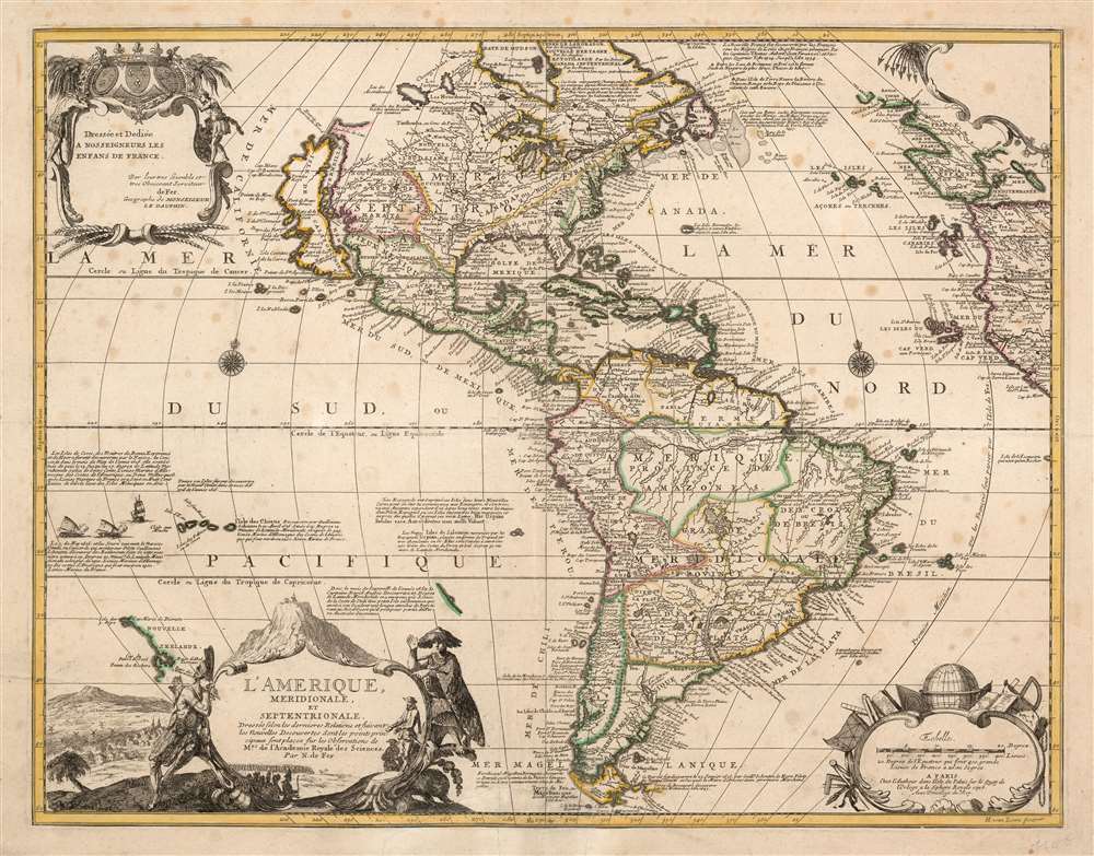

Title
L'Amerique, meridionale, et septentrionale Dressée selon les Dernieres Relations et suivant les Nouvelles Decouvertes dont les pounts prin= cipaux sont placez sur les Observations de Mrs. de l'Academie Royale des Sciences.
1705 (dated) 18.25 x 23.5 in (46.355 x 59.69 cm) 1 : 40000000
1705 (dated) 18.25 x 23.5 in (46.355 x 59.69 cm) 1 : 40000000
Description
This is Nicolas de Fer's 1699 map of America, in a lovely old color example of the second state, printed in 1705. Both of the first two states of this map were separately issued, and are consequently rare. This detailed and richly annotated map, derived from De Fer's own 1698 L'Amerique Divisée Selon Letendue de set Principales Parties, shows the Americas during a period in which France was dominant in the exploration and mapping of North America. Its superb engraving is the work of Harmanus Van Loon, who also engraved De Fer's larger-scale work.
Richly Decorative
Van Loon's engraving presents the cartographic detail clearly, but does not neglect the decorative content. A sea-battle is depicted in the South Pacific, and there are two elegant compass roses. The map's dedicatory cartouche in the upper left, flanked by native figures, is surmounted with royal arms and fleurs-de-lis; the dedication is to Nosseigneurs les Enfens de France, that is to say the Royal Princes of France, and not French children en masse. The title cartouche on the lower left, also flanked by indigenous figures, is set before a depiction of the mountain of Potosi (the location in Bolivia of the Spanish Colonial silver mint) and its surrounding city and windmills. The map's scales are displayed in the lower right, their cartouche embellished with geographers' tools such as a globe, rulers, maps, pens, and so on. A cartouche in the upper right (decorated with a coconut tree with oddly spear-shaped leaves) is blank in the first four states of the map; it would not receive text until the 1726 Benard state.North American Geography
DeFer's map displays the Great Lakes and the Mississippi watershed based on state-of-the-art geography of the Academie Royale des Sciences, much of which can be ascribed to Jean Baptiste-Louis Franquelin's firsthand reports. All five Great Lakes are shown; Hudson's bay is properly aligned with them. While their southern reaches are better oriented to the east coast than on the preceding Fr. Hennepin maps, De Fer's mapping of that coast is confused, with a greatly distorted Chesapeake Bay, an archaic John Smith-era treatment of Virginia, and a meager portioning of New England. The Mississippi, much like the Hennepin maps before it, is reasonably accurate despite the mouth being situated too far west (in the vicinity of Galveston Bay) and the placement of the Ohio River too far south. The map contains an early, reasonably accurate delineation of the Missouri River (Outanes R. on the map).Insular California: Luke Foxe / Sanson Model
California is shown in insular form, one of the last instances of this prior to the correction of the myth in the early 18th century. The version presented here is often erroneously referred to as the 'Sanson Model.' The term is in fact derived from a 1635 map of the North American Arctic drawn by Luke Foxe. It was Foxe who invented many of the place names as well as added various bays and inlets to northern California. Among these are Talaaago, R. de Estiete, and the curious peninsula extending westward form the mainland, Agubela de Cato. Foxe's sources remain a mystery and his mapping may be based upon nothing more than fantasy, but Sanson embraced the model whole heartedly. Although Sanson did not invent this form of insular California, his substantial influence did popularize it with subsequent cartographers. As is often the case with insular California cartography, the Pacific Northwest is left ambiguous with the interior of Canada occupied by speculative lakes and rivers. There appear to be more concrete reports as well from this region, such as the Recollect mission placed in the vicinity of Lake Winnipeg, ( Assinibouels on the map) far to the west of the locations that are typically understood to have fallen within reach of the Recollect Friars. De Fer places the mission there on his earlier maps as well. In the American southwest, the Rio Grande is shown flowing to the Gulf of Mexico (rather than having it empty into the Gulf of California in the frequent 17th century conflation of this river with the Colorado.Historical Annotations
As with De Fer's L'Amerique Divisée Selon Letendue de set Principales Parties, the map contains many text annotations explaining specific geographic features and their history, among them the discovery of the strait of Le Maire, discoveries of islands in the South Pacific, the 16th century French exploration of the coasts of New France by Verrazano, Aubert, and Cartier, and the long history of European fishing off the Grand Banks.Publication History and Census
This map is scarce, and rare in its first two states. It was engraved in 1699 and sold as a separate issue until the 1709 publication of the De Fer Atlas ou Recueil de Cartes. While examples of a much smaller De Fer map by the same title appear to be relatively common, we do not see this map in OCLC. We are aware of an early state at the Bibliotheque Nationale, a 1742 state 6 in the Rumsey collection, and an example dated 1727 which appears to be otherwise consistent with state 4 in the Leventhal collection.CartographerS
Nicholas de Fer (1646 - October 25, 1720) was a French cartographer and publisher, the son of cartographer Antoine de Fer. He apprenticed with the Paris engraver Louis Spirinx, producing his first map, of the Canal du Midi, at 23. When his father died in June of 1673 he took over the family engraving business and established himself on Quai de L'Horloge, Paris, as an engraver, cartographer, and map publisher. De Fer was a prolific cartographer with over 600 maps and atlases to his credit. De Fer's work, though replete with geographical errors, earned a large following because of its considerable decorative appeal. In the late 17th century, De Fer's fame culminated in his appointment as Geographe de le Dauphin, a position that offered him unprecedented access to the most up to date cartographic information. This was a partner position to another simultaneously held by the more scientific geographer Guillaume De L'Isle, Premier Geograph de Roi. Despite very different cartographic approaches, De L'Isle and De Fer seem to have stepped carefully around one another and were rarely publicly at odds. Upon his death of old age in 1720, Nicolas was succeeded by two of his sons-in-law, who also happened to be brothers, Guillaume Danet (who had married his daughter Marguerite-Geneviève De Fer), and Jacques-François Bénard (Besnard) Danet (husband of Marie-Anne De Fer), and their heirs, who continued to publish under the De Fer imprint until about 1760. It is of note that part of the De Fer legacy also passed to the engraver Remi Rircher, who married De Fer's third daughter, but Richer had little interest in the business and sold his share to the Danet brothers in 1721. More by this mapmaker...
Harmanus van Loon (fl. c. 1690 - c. 1725) was a Flemish engraver active in Paris during the late 17th and early 18th centuries. Van Loon worked primarily in Paris and often signed his work, which includes maps and other engravings for such prominent cartographers as Nicolas de Fer, Jean Baptiste Nolin, Guillaume Delisle, and others. There is some speculation that he may have been related to the Brussels born painter Theodorus van Loon. Learn More...
Condition
Very good condition. Old reinforcement of margins and few mended marginal tears. Lightly toned with some spotting, else an attractive example with old hand color.
References
OCLC 921699467. Rumsey 10022.011. Burden, P., The Mapping of North America II, #753 State 2. McLaughlin, G., The Mapping of California as an Island: An Illustrated Checklist, #127. Leventhal Map Collection call # G3290 1727 .F47x.