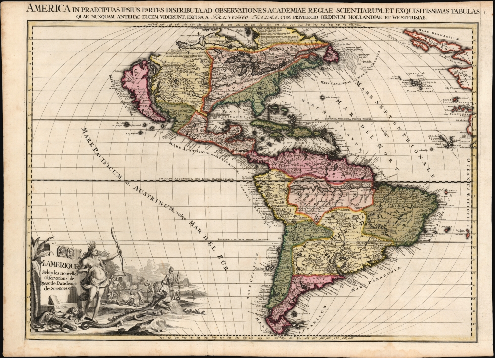
This is the rare first state of François Halma's c. 1699 separately-issued map of America. Its unusually large folio size, bold and sophisticated engraving, and rich original color sets this map apart as one of the most beautiful late-seventeenth century maps of the Americas available to the collector. It dramatically presents some of the most notable geographic ideas of its era, including a prominent insular California after the Sanson model. The Great Lakes and the course of the Mississippi, as well as the rest of the American coastline, closely resembles that of Nicolas de Fer's 1699 L'Amerique.
State-of-the-Art Geography
That geography as presented here shows the Great Lakes and the Mississippi watershed based on state-of-the-art geography of the Académie Royale des Sciences, much of which can be ascribed to Jean Baptiste-Louis Franquelin's firsthand reports. All five Great Lakes are shown and Hudson's Bay is properly aligned. While their southern reaches are better oriented to the east coast than on the preceding Fr. Hennepin maps, the mapping of that coast is confused, with a greatly distorted Chesapeake Bay, an archaic John Smith-era treatment of Virginia, and a meager portioning of New England. The Mississippi, much like the Hennepin maps before it, is reasonably accurate despite the mouth being situated too far west (in the vicinity of Galveston Bay) and the placement of the Ohio River too far south. The map contains an early, reasonably accurate delineation of the Missouri River (Outanes R. on the map).Insular California: Luke Foxe / Sanson Model
California is shown in insular form, one of the last instances of this prior to the correction of the myth in the early 18th century. The version presented here is often erroneously referred to as the 'Sanson Model.' The term is in fact derived from a 1635 map of the North American Arctic drawn by Luke Foxe. It was Foxe who invented many of the place names as well as added various bays and inlets to northern California. Among these are Talaaago, R. de Estiete, and the curious peninsula extending westward form the mainland, Agubela de Cato. Foxe's sources remain a mystery and his mapping may be based upon nothing more than fantasy, but Sanson embraced the model wholeheartedly. Although Sanson did not invent this form of insular California, his substantial influence did popularize it with subsequent cartographers. As is often the case with insular California cartography, the Pacific Northwest is left ambiguous with the interior of Canada occupied by speculative lakes and rivers. In the American southwest, the Rio Grande is shown flowing to the Gulf of Mexico (rather than having it empty into the Gulf of California in the frequent 17th century conflation of this river with the Colorado).Historical Notation
Halma's map preserves De Fer's many text annotations explaining specific geographic features and their history, among them the discovery of the strait of Le Maire, discoveries of islands in the South Pacific, the 16th century French exploration of the coasts of New France by Verrazano, Aubert, and Cartier, and the long history of European fishing off the Grand Banks.A Magnificent Baroque Cartouche
The title cartouche is founded on a plinth bearing the images of both Columbus and Vespucci. Before the plinth, a female Native American figure representing America brandishes a bow. Between her and the plinth lies a gruesome, severed head with an arrow through the neck; an alligator prowls the foreground whilst in the background a cannibalistic feast is being prepared.Publication History and Census
The map was printed by François Halma, probably after 1699 although it is possible that it shares a source with the De Fer, in which case it is no earlier than 1696. It was masterfully composed by Jan Goeree, and superbly engraved by the unjustly obscure J. Baptist. Halma produced no full-size atlas of his own, but this map was accompanied by similarly grand maps of Asia, Africa and Europe, and likely Halma's 1696 north polar projection world after Cassini. Before 1713 the plates were acquired by Leiden map publisher Pieter van der Aa, who replaced Halma's imprints with his own and included the maps in his 1713 Le Nouveau Théâtre du Monde. Halma's separately issued maps, destined for decorative use or tipping into composite atlases by other publishers, have survived in only a few examples. We are aware of only one other example of this edition of this map coming to the market, and there is but a single example catalogued in OCLC, tipped into a Visscher atlas now held by the Newberry Library.
CartographerS
François Halma (1653 - 1722) was a Dutch publisher active in Utrecht (starting 1674) and later in Amsterdam where he worked as printer and publisher from 1699-1710. He eventually settled at Leeuwarden, where he died. His output was composed of botanical, theological and historical works, but also, he published a small number of geographies and atlases. In 1695, he published an edition of Gerard Mercator's Ptolemy. His re-issue of Schotanus à Sterringa’s Friesche Atlas in 1698 was regarded among his finest work. He also published an edition of Sanson’s Description de l’Univers. He produced an edition of Falda's plan of Rome in or around 1700. He also caused to be engraved a set of large-format maps of the continents and the world (this latter after Cassini) which are quite rare and appear to have been separately issued. We are aware of institutional copies of the continents having been bound into a 1710 Visscher atlas. The execution of these large and rare maps, drawn by Jan Goeree and engraved by Jan Baptiste, was of a very high quality. The plates were later acquired and reprinted, virtually unchanged, by Pieter van der Aa in 1713. More by this mapmaker...
Jan Goeree (1670 - 1731) was a Dutch painter, draughtsman and printmaker. He was also known as a poet. He was the son of one Willem Goeree and no details come down to us of his youth in Middleburg. In Amsterdam he was a pupil of Dutch Golden Age painter and art theorist Gerard de Lairesse. He lived out his life in Amsterdam, the city in which most of his work was produced. His engraving appeared in De Fer's Atlas Royal. Tooley's Dictionary is probably mistaken in saying he worked for Pieter van der Aa. Although his imprint is to be found on van der Aa's large format maps, these were executed on behalf of François Halma as early as 1694, and the plates later acquired and reprinted by van der Aa in 1713. Learn More...
J. Baptist (active late 17th century) was an engraver active in the Netherlands in the latter part of the 17th century and possibly into the early 18th. We see his imprint virtually only in the work of François Halma (any connection with the later work of Pieter van der Aa is extremely tenuous; as the Aa plates attributed to Baptist were actually executed on behalf of Halma and later purchased by the Leiden publisher.) Learn More...
Nicholas de Fer (1646 - October 25, 1720) was a French cartographer and publisher, the son of cartographer Antoine de Fer. He apprenticed with the Paris engraver Louis Spirinx, producing his first map, of the Canal du Midi, at 23. When his father died in June of 1673 he took over the family engraving business and established himself on Quai de L'Horloge, Paris, as an engraver, cartographer, and map publisher. De Fer was a prolific cartographer with over 600 maps and atlases to his credit. De Fer's work, though replete with geographical errors, earned a large following because of its considerable decorative appeal. In the late 17th century, De Fer's fame culminated in his appointment as Geographe de le Dauphin, a position that offered him unprecedented access to the most up to date cartographic information. This was a partner position to another simultaneously held by the more scientific geographer Guillaume De L'Isle, Premier Geograph de Roi. Despite very different cartographic approaches, De L'Isle and De Fer seem to have stepped carefully around one another and were rarely publicly at odds. Upon his death of old age in 1720, Nicolas was succeeded by two of his sons-in-law, who also happened to be brothers, Guillaume Danet (who had married his daughter Marguerite-Geneviève De Fer), and Jacques-François Bénard (Besnard) Danet (husband of Marie-Anne De Fer), and their heirs, who continued to publish under the De Fer imprint until about 1760. It is of note that part of the De Fer legacy also passed to the engraver Remi Rircher, who married De Fer's third daughter, but Richer had little interest in the business and sold his share to the Danet brothers in 1721. Learn More...
Excellent. Few marginal mends well away from printed image; with a bold strike, attendant to the youth of the plate. Superb original color.
OCLC 925491228.