This item has been sold, but you can get on the Waitlist to be notified if another example becomes available, or purchase a digital scan.
1874 Sudo Manuscript Map of Xiamen (Amoy), Fujian, China
Amoy-sudo-1874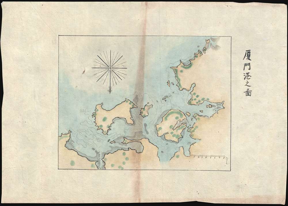

Title
厦門港之圖 / Map of Xiamen Port.
1874 (dated) 10.5 x 15 in (26.67 x 38.1 cm) 1 : 400000
1874 (dated) 10.5 x 15 in (26.67 x 38.1 cm) 1 : 400000
Description
Part of Sudo Collection. Not sold Separately: Click here for full collection.
A striking 1874 manuscript map of Amoy or Xiamen harbor (厦门市), Fujian, China. The map is oriented to the South, but covers Xiamen Island and Kinmen Island, as well as Weitou Bay, Dongju Harbour, Zengzhou Harbor, and extends inland as far as Haimen Island. Cartographically, Sudo probably based this chart on the British Hydrographic office work of Captain Kellett c. 1870. In 1874, Sudo was attempting to travel to Shanghai in mainland China from Taiwan. As such, Xiamen would have been one of his first stops in the mainland.
A striking 1874 manuscript map of Amoy or Xiamen harbor (厦门市), Fujian, China. The map is oriented to the South, but covers Xiamen Island and Kinmen Island, as well as Weitou Bay, Dongju Harbour, Zengzhou Harbor, and extends inland as far as Haimen Island. Cartographically, Sudo probably based this chart on the British Hydrographic office work of Captain Kellett c. 1870. In 1874, Sudo was attempting to travel to Shanghai in mainland China from Taiwan. As such, Xiamen would have been one of his first stops in the mainland.
Cartographer
Sudo Katsuzō (湏藤 / 湏藤勝三; c. 1848 - c. 1874) was a Japanese cartographer of Tochigi Prefecture (栃木県 / Tochigi-ken), Japan. Sudo was part of an 1874 mission to Taiwan and subsequently to the mainland of China. As part of this expedition, he produced a series of maps detailing Taiwan and some major cities in Fujian, including Fuzhou and Xiamen. The quality and execution of the maps suggest that he was experienced in both western and Japanese cartographic styles, indicating that he may have had training as a military engineer. Sudo apparently died of an unknown illness shortly after the maps were made, at just 26, so it is not surprising that little is recorded regarding his history. His maps were subsequently collected by his brother and remained in the family until recently. More by this mapmaker...
Condition
Very good. On thin Japanese paper. Manuscript.