Digital Image: 1886 Yaggy Anatomical Study of Human Anatomy
AnatomicalStudy-yaggy-1886_d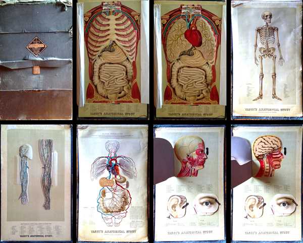

Title
Yaggy's Anatomical Study Presenting the Skeleton, Muscles, Arteries, Veins and Nerves also Four Life-Size Manikins of The Body, The Head, The Eye and Ear with Additional Manikins of Arm and Leg.
1886 (dated) 30 x 18 in (76.2 x 45.72 cm)
1886 (dated) 30 x 18 in (76.2 x 45.72 cm)
Description
FOR THE ORIGINAL ANTIQUE MAP, WITH HISTORICAL ANALYSIS, CLICK HERE.
Digital Map Information
Geographicus maintains an archive of high-resolution rare map scans. We scan our maps at 300 DPI or higher, with newer images being 600 DPI, (either TIFF or JPEG, depending on when the scan was done) which is most cases in suitable for enlargement and printing.
Delivery
Once you purchase our digital scan service, you will receive a download link via email - usually within seconds. Digital orders are delivered as ZIP files, an industry standard file compression protocol that any computer should be able to unpack. Some of our files are very large, and can take some time to download. Most files are saved into your computer's 'Downloads' folder. All delivery is electronic. No physical product is shipped.
Credit and Scope of Use
You can use your digial image any way you want! Our digital images are unrestricted by copyright and can be used, modified, and published freely. The textual description that accompanies the original antique map is not included in the sale of digital images and remains protected by copyright. That said, we put significant care and effort into scanning and editing these maps, and we’d appreciate a credit when possible. Should you wish to credit us, please use the following credit line:
Courtesy of Geographicus Rare Antique Maps (https://www.geographicus.com).
How Large Can I Print?
In general, at 300 DPI, you should at least be able to double the size of the actual image, more so with our 600 DPI images. So, if the original was 10 x 12 inches, you can print at 20 x 24 inches, without quality loss. If your display requirements can accommodate some loss in image quality, you can make it even larger. That being said, no quality of scan will allow you to blow up at 10 x 12 inch map to wall size without significant quality loss. For more information, it is best consult a printer or reprographics specialist.
Refunds
If the high resolution image you ordered is unavailable, we will fully refund your purchase. Otherwise, digital images scans are a service, not a tangible product, and cannot be returned or refunded once the download link is used.
Cartographer
Levi Walter Yaggy (July 16, 1848 - October 18, 1912) was an American author, publisher, and inventor. Born in Plainfield, Illinois to Jacob Yaggy and Elizabeth Pfister Yaggy, Levi attended Northwestern College in Naperville, Illinois before moving to Chicago, where he established a publishing house named the Great Western Publishing House in 1874. Yaggy served as the president and chief stockholder of the publishing house, which eventually grew to include seventeen branch offices and five thousand agents throughout the United States. Great Western Publishing focused mainly on the publication of maps and studies for colleges and high schools, and was for years the foremost publisher of this genre of material in the United States. Yaggy held several patents, including one for a stubble turner, which was very lucrative, one or an adding machine different, and a Chautauqua desk. Upton completion of a relief map fo the United States for the Smithsonian Institute in Washington D.C., Yaggy was made a fellow of the Royal Geographical Society of England. During a hunting trip in Kansas in 1888, Yaggy noticed a well being dug, and remarked that the water level was only a few feet below the surface. He immediately purchased the entire estate and planned catalpa and apple trees. This plantation grew into one of the most lucrative in the country. More by this mapmaker...
Source
Western Publishing House, Yaggy's Anatomical Study, Chicago, 1886.
References
OCLC 25987510.