Digital Image: 1918 Bernard Sleigh 'Anciente Mappe of Fairlyand'
AncienteMappeofFariyland3-sleigh-1918_d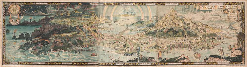

Title
An Anciente Mappe of Fairy Land newly discovered and set forth.
1918 (undated) 20 x 72.5 in (50.8 x 184.15 cm) Scale of Thoughts.
1918 (undated) 20 x 72.5 in (50.8 x 184.15 cm) Scale of Thoughts.
Description
FOR THE ORIGINAL ANTIQUE MAP, WITH HISTORICAL ANALYSIS, CLICK HERE.
Digital Map Information
Geographicus maintains an archive of high-resolution rare map scans. We scan our maps at 300 DPI or higher, with newer images being 600 DPI, (either TIFF or JPEG, depending on when the scan was done) which is most cases in suitable for enlargement and printing.
Delivery
Once you purchase our digital scan service, you will receive a download link via email - usually within seconds. Digital orders are delivered as ZIP files, an industry standard file compression protocol that any computer should be able to unpack. Some of our files are very large, and can take some time to download. Most files are saved into your computer's 'Downloads' folder. All delivery is electronic. No physical product is shipped.
Credit and Scope of Use
You can use your digial image any way you want! Our digital images are unrestricted by copyright and can be used, modified, and published freely. The textual description that accompanies the original antique map is not included in the sale of digital images and remains protected by copyright. That said, we put significant care and effort into scanning and editing these maps, and we’d appreciate a credit when possible. Should you wish to credit us, please use the following credit line:
Courtesy of Geographicus Rare Antique Maps (https://www.geographicus.com).
How Large Can I Print?
In general, at 300 DPI, you should at least be able to double the size of the actual image, more so with our 600 DPI images. So, if the original was 10 x 12 inches, you can print at 20 x 24 inches, without quality loss. If your display requirements can accommodate some loss in image quality, you can make it even larger. That being said, no quality of scan will allow you to blow up at 10 x 12 inch map to wall size without significant quality loss. For more information, it is best consult a printer or reprographics specialist.
Refunds
If the high resolution image you ordered is unavailable, we will fully refund your purchase. Otherwise, digital images scans are a service, not a tangible product, and cannot be returned or refunded once the download link is used.
Cartographer
Bernard Sleigh (1852 - December 7, 1954) was a British author, muralist, stained-glass artist, illustrator and wood engraver active in London in the late 18th and early 19th centuries. Sleigh was born in Birmingham, England and studied at the Birmingham School of art. He was a student of Arthur Gaskin. His work is deeply influenced by his early association with William Morris and the Arts and Crafts Movement. He was a member of the Royal Birmingham Society of Artists between 1923 and 1928. His most famous cartographic work is An Ancient Mappe of Fairyland, Newly Discovered and Set Forth, published at the end of the Great War or World War I. He also published several less well known maps of Birmingham and other parts of England. Sleigh retired to Chipping Campden in 1937. For those who are unacquainted with 'Chipping Campden' or 'Chippy,' in the heart of England's picturesque Cotswolds, it is a place that seems more akin to 'Fairy Land' than to the modern industrial world. More by this mapmaker...
References
Baynton-Williams, A., The Curious Map Book, pages 212 - 213. Bryers, Time, and Haper, Tom, A Histroy of the Twentieth Century in 100 Maps, pages 58-59. Boston Public Library, Leventhal Collection, G9930 1917 .S5.