This item has been sold, but you can get on the Waitlist to be notified if another example becomes available, or purchase a digital scan.
1645 Blaeu Map of England and Wales
AngliaRegnum-blaeu-1645$225.00

Title
Anglia Regnum.
1645 (undated) 15.5 x 20 in (39.37 x 50.8 cm) 1 : 700000
1645 (undated) 15.5 x 20 in (39.37 x 50.8 cm) 1 : 700000
Description
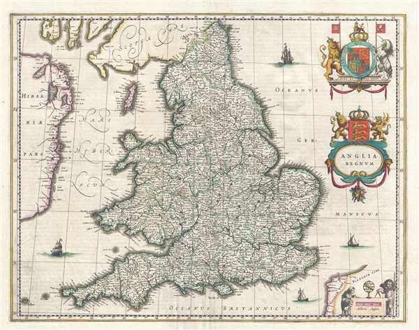
This is a c. 1645 Blaeu map of England and Wales. The map depicts the region from Ireland to the North Sea and from Scotland to the English Channel and Calais. Highly detailed, innumerable cities, towns, and villages are labeled throughout England and Wales, including London, Cardiff, Bristol, and Cambridge. Counties are illustrated and labeled, with a pale green indicating the boundaries between them. Several points along the Irish coast are labeled, along with Dublin and other cities and towns along the coast. Both the Isle of Man and the Isle of Wight are illustrated and labeled as well. Ships are illustrated in the North Sea, the English Channel, and the Irish Sea and the coats of arms of Great Britain and England are situated along the right border, with the coat of arms of England integrated into the title cartouche. A cartouche for the scale is included in the lower right corner and is flanked by two sheep and a cherub. The cherub is performing some sort of calculation, with the help of a compass and an armillary.
This map was published by the Blaeu family in an edition of their Atlas Major c. 1645.
This map was published by the Blaeu family in an edition of their Atlas Major c. 1645.
Cartographer
Joan (Johannes) Blaeu (September 23, 1596 - December 21, 1673) was a Dutch cartographer active in the 17th century. Joan was the son of Willem Janszoon Blaeu, founder of the Blaeu firm. Like his father Willem, Johannes was born in Alkmaar, North Holland. He studied Law, attaining a doctorate, before moving to Amsterdam to join the family mapmaking business. In 1633, Willem arranged for Johannes to take over Hessel Gerritsz's position as the official chartmaker of the Dutch East India Company, although little is known of his work for that organization, which was by contract and oath secretive. What is known is his work supplying the fabulously wealthy VOC with charts was exceedingly profitable. Where other cartographers often fell into financial ruin, the Blaeu firm thrived. It was most likely those profits that allowed the firm to publish the Theatrum Orbis Terrarum, sive, Atlas Novus, their most significant and best-known publication. When Willem Blaeu died in 1638, Johannes, along with his brother Cornelius Blaeu (1616 - 1648) took over the management of the Blaeu firm. In 1662, Joan and Cornelius produced a vastly expanded and updated work, the Atlas Maior, whose handful of editions ranged from 9 to an astonishing 12 volumes. Under the brothers' capable management, the firm continued to prosper until the 1672 Great Amsterdam Fire destroyed their offices and most of their printing plates. Johannes Blaeu, witnessing the destruction of his life's work, died in despondence the following year. He is buried in the Dutch Reformist cemetery of Westerkerk. Johannes Blaeu was survived by his son, also Johannes but commonly called Joan II, who inherited the family's VOC contract, for whom he compiled maps until 1712. More by this mapmaker...
Condition
Very good. Even overall toning. Repair to margin centerfold separation. French text on verso.
References
Rumsey 10017.295 (1665 edition). OCLC 43181652.