1905 Comissão de Cartografia Map of Central Angola (Portuguese West Africa)
Angola-comissaocartographia-1905$2,000.00

Title
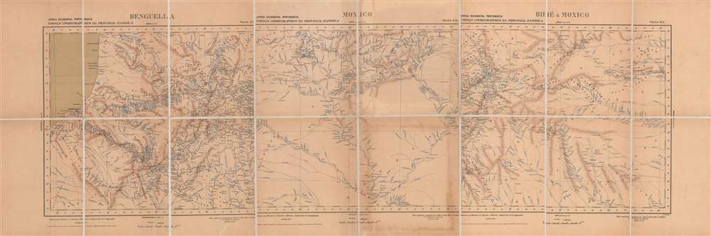
Africa occidental portugueza, Esboço chorographico da provincia d'Angola - Benguela, Moxico, Bihé e Moxico.
1905 (dated) 17 x 56 in (43.18 x 142.24 cm) 1 : 1000000
1905 (dated) 17 x 56 in (43.18 x 142.24 cm) 1 : 1000000
Description
This is a large 1905 folding map combining three sheets of regions in the central part of Angola (Portuguese West Africa) made by the Comissão de Cartografia das Colónias. It was published at a time when European powers were fixing borders between their colonies following the 'Scramble for Africa' and Portugal was attempting to exert control over the interior of Angola.
In 1902, a sudden drop in the price of rubber combined with a famine, a smallpox outbreak, and resentment against the newly intrusive Portuguese presence precipitated a revolt. The rebels besieged the Forte do Bailundo, towards top-right of the left-hand sheet, for months and attacked trading posts, targeting indigenous traders in particular. The Portuguese assembled forces containing colonial settlers, Boers, and indigenous troops for a counter-attack and, as they possessed modern weaponry such as repeating rifles, easily defeated the Bailundo forces, though sporadic resistance continued for many months.
As one of the commanders of the campaign, de Amorim would have had better functional knowledge of the geography of the region shown here than almost any other figure in the colonial or military bureaucracy. Given the time of publication noted on the sheets, it is likely that de Amorim developed these maps when back in Lisbon, between stints in Angola, perhaps from sketches made during the campaign itself.
In the wake of the Berlin Conference, rival colonial powers raced to establish 'effective occupation' and claim territory. In addition to the Congo Free State, the German Empire had their claims in Southwestern Africa (now Namibia) confirmed at the Berlin Conference, while British interests were rapidly expanding in the areas Portugal had recently claimed in the Pink Map, which were informally and then formally known as Rhodesia (seen here at bottom-center).
As with most other railways in Angola and Mozambique, the Benguela Railway was constructed and owned by companies whose managers and stockholders were mostly British, despite the two empires' territorial rivalry. The railway was especially profitable given the reliable mineral wealth of the areas it reached and the relatively close proximity of Lobito to Europe by ship (compared to ports further south or around the Horn of Africa). Usage peaked in the early 1970s, but the railway was heavily damaged by Angolan Civil War, which ended in 2002. Afterwards, the railway was reconstructed by the China Railway Construction Corporation and was formally reopened in 2015, with the full line from Tenke (in the Democratic Republic of the Congo) to Lobito reopening in 2018.
In the early-mid 19th century, the government launched a renewed effort to move colonists further inland and strengthen direct control over the interior. Angola underwent fundamental changes with the abolition of the slave trade in 1836. Although human trafficking and forced labor continued to be commonplace, the colonial ports of Angola (especially Luanda) shifted away from slave trading and developed new commercial markets, growing considerably in the process.
The 'Scramble for Africa' at the end of the century presented Portugal with both risks and opportunities. But they were incapable of challenging the British and had to grudgingly accept a secondary role among European colonial powers. Nevertheless, the British and Portuguese were both wary of German expansion in Africa in the late 19th century and collaborated against Germany during the First World War. Although Portugal was neutral at the start of the conflict, it supplied the British and French armies on the Western Front and was eventually drawn into the war on the Allied side in 1916, focusing mainly on protecting its African colonies.
In the interwar period, with the threat of anti-colonial movements looming, Portugal moved towards a notion of 'pluricontinental' nationhood. Nevertheless, with the wave of decolonization that followed World War II, Portugal faced the prospect of losing its colonies. But the country's Prime Minister and de facto dictator, António de Oliveira Salazar, categorically refused decolonization and aimed to crush guerilla movements in Angola, Mozambique, and Portuguese Guinea (now Guinea-Bissau). Counter-insurgency efforts were largely successful as a short-term solution, but failed to resolve underlying problems, and when Salazar's successor Marcelo Caetano was toppled in a coup in 1974, Portugal's empire quickly collapsed. Angola and Mozambique then descended into protracted civil wars that became Cold War proxy conflicts that were only resolved in the early 1990s.
A Closer Look
This map covers territory including what was then Benguela Province, which extended from the coastal city of Benguela far into the interior, through the Bié (Bihé) Plateau (also known as the Central Highlands) and to the (loosely defined) borders of the Congo Free State and Rhodesia in Moxico and Lunda. It is in fact a combination of three folding maps, which, as the longitude lines indicate, do not proceed smoothly from west to east. The territory shown on the middle sheet covering Moxico is to the east of the right-hand sheet covering Bihé and Moxico. The map is extremely detailed in noting settlements, roads (such as they were), rivers, and mountains in the Angolan interior.Bailundo Revolt
These maps were made by Pedro Francisco Massano de Amorim, a military officer and later Governor-General of Angola, who commanded one of three columns during a campaign in 1902 - 1904 to suppress a revolt by the Bailundo Kingdom and its allies on the Benguela Highlands. In the decades beforehand, the Portuguese had constructed fortresses (visible here) on the lands of Ovimbundu kingdoms, of which Bailundo was one, in an effort to shore up its very tenuous control over inland regions of Angola, and especially the profitable trading routes leading to the coast. At the end of the 19th century, the Portuguese toppled the king of the Bié kingdom, changing the political arrangements of the region, while also bringing in Portuguese and Boer settlers to manage trade and extractive industries (especially rubber).In 1902, a sudden drop in the price of rubber combined with a famine, a smallpox outbreak, and resentment against the newly intrusive Portuguese presence precipitated a revolt. The rebels besieged the Forte do Bailundo, towards top-right of the left-hand sheet, for months and attacked trading posts, targeting indigenous traders in particular. The Portuguese assembled forces containing colonial settlers, Boers, and indigenous troops for a counter-attack and, as they possessed modern weaponry such as repeating rifles, easily defeated the Bailundo forces, though sporadic resistance continued for many months.
As one of the commanders of the campaign, de Amorim would have had better functional knowledge of the geography of the region shown here than almost any other figure in the colonial or military bureaucracy. Given the time of publication noted on the sheets, it is likely that de Amorim developed these maps when back in Lisbon, between stints in Angola, perhaps from sketches made during the campaign itself.
European Scramble for Western Africa
In the years before this map was made, the Portuguese and rival European colonial powers vied for influence in southwestern Africa. In the late 1870s and 1880s, the Portuguese tried to establish an East-West corridor between Mozambique and Angola across central Africa, a plan laid out in the famous 1885 Mapa cor-de-rosa (Pink Map). This project was motivated by the doctrine of effective occupation agreed to at the Berlin Conference of 1884 – 1885, where the Portuguese also gained the support of other European powers for their plan, except for Britain, whose subjects were advancing into these same areas and who imagined a string of colonies running north and south 'from the Cape to Cairo' that would intersect with Portugal's claims. Another product of the Berlin Conference was the creation of the Congo Free State, a private colony of Belgian King Leopold II that became a horrific showcase of the worst atrocities of European colonialism (seen at top in the middle sheet).In the wake of the Berlin Conference, rival colonial powers raced to establish 'effective occupation' and claim territory. In addition to the Congo Free State, the German Empire had their claims in Southwestern Africa (now Namibia) confirmed at the Berlin Conference, while British interests were rapidly expanding in the areas Portugal had recently claimed in the Pink Map, which were informally and then formally known as Rhodesia (seen here at bottom-center).
Railways and Inter-imperial Relations
Accompanying the rush to claim territory was a dash to locate and exploit the incredibly rich mineral resources of southern Africa, which necessitated the building of railways. The Benguela Railway began construction in 1903 with the intention of reaching the Katangan (southern Congo) and Zambian Copperbelts and the first section was completed in 1905, seen here connecting Benguela to Caconda. Despite its name, the line actually terminated at the port of Lobito just north of the city of Benguela, making clear its primary function as a freight railway. Although progress was steady, the railway was not completed until 1929 due to the difficult terrain and a delay caused by the First World War.As with most other railways in Angola and Mozambique, the Benguela Railway was constructed and owned by companies whose managers and stockholders were mostly British, despite the two empires' territorial rivalry. The railway was especially profitable given the reliable mineral wealth of the areas it reached and the relatively close proximity of Lobito to Europe by ship (compared to ports further south or around the Horn of Africa). Usage peaked in the early 1970s, but the railway was heavily damaged by Angolan Civil War, which ended in 2002. Afterwards, the railway was reconstructed by the China Railway Construction Corporation and was formally reopened in 2015, with the full line from Tenke (in the Democratic Republic of the Congo) to Lobito reopening in 2018.
Portugal's 'Third Empire'
In the early 19th century, Portugal was no longer a great world power, and its empire was significantly reduced, especially after the independence of Brazil in 1822. But the empire did still maintain a string of colonies, the largest of which were Angola and Mozambique. Some Portuguese had ventured into the African interior in the early days of their colonial presence and set up estates and trading post-garrisons. However, settlers were few in number and generally intermarried with the local population to the point that they lost Portuguese identity, while the estates were operated like independent fiefdoms rather than a shared colonial enterprise. In Mozambique, the Portuguese inclination to try to force Christianity on their trading partners and use the presence of Muslim traders as an excuse for military campaigns also provoked opposition, while in Angola Portuguese rule was determined (and limited) by long and complicated relationships with several indigenous kingdoms, especially the Christian, Lusophone Kingdom of Kongo. For most of the colonial era, the Portuguese satisfied themselves with operating a handful of coastal outposts for exporting slaves to the New World. Therefore, Portugal's control was limited to ports and most of the people it claimed to rule were effectively independent.In the early-mid 19th century, the government launched a renewed effort to move colonists further inland and strengthen direct control over the interior. Angola underwent fundamental changes with the abolition of the slave trade in 1836. Although human trafficking and forced labor continued to be commonplace, the colonial ports of Angola (especially Luanda) shifted away from slave trading and developed new commercial markets, growing considerably in the process.
The 'Scramble for Africa' at the end of the century presented Portugal with both risks and opportunities. But they were incapable of challenging the British and had to grudgingly accept a secondary role among European colonial powers. Nevertheless, the British and Portuguese were both wary of German expansion in Africa in the late 19th century and collaborated against Germany during the First World War. Although Portugal was neutral at the start of the conflict, it supplied the British and French armies on the Western Front and was eventually drawn into the war on the Allied side in 1916, focusing mainly on protecting its African colonies.
In the interwar period, with the threat of anti-colonial movements looming, Portugal moved towards a notion of 'pluricontinental' nationhood. Nevertheless, with the wave of decolonization that followed World War II, Portugal faced the prospect of losing its colonies. But the country's Prime Minister and de facto dictator, António de Oliveira Salazar, categorically refused decolonization and aimed to crush guerilla movements in Angola, Mozambique, and Portuguese Guinea (now Guinea-Bissau). Counter-insurgency efforts were largely successful as a short-term solution, but failed to resolve underlying problems, and when Salazar's successor Marcelo Caetano was toppled in a coup in 1974, Portugal's empire quickly collapsed. Angola and Mozambique then descended into protracted civil wars that became Cold War proxy conflicts that were only resolved in the early 1990s.
Publication History and Census
This map was organized and drawn by Captain Massano de Amorim, an artillery officer of the General Staff, and published by M. Diniz of the Comissão de Cartografia das Colónias, an office within the Portuguese Ministério da Marinha e Ultramar, in 1905. It is a combination of Sheets No. 7, 15, and 11 in the in the collection Africa Occidental Portugueza (OCLC 556374173, 433409223). The individual maps are cataloged in the holdings of the University of Cape Town, while the entire collection is held by the British Library and the Library of Congress. This presentation of the three sheets combined is not known to exist in any institutional holdings and has no known history on the market.Cartographer
Comissão de Cartografia das Colónias (fl. c. 1883 - 1936), in its early years as 'Comissão de Cartographia das Colónias', was an office within the Ministério da Marinha e Ultramar tasked with surveying Portugal's colonies, primarily in Africa. It was dissolved in 1936 and replaced with Junta das Missões Geográficas e de Investigações Colonia. More by this mapmaker...
Condition
Very good. Some staining around margins of sheet at bottom-center.