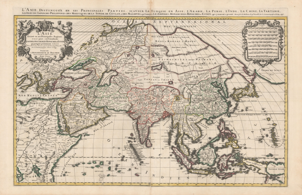
1696 Jaillot-Mortier Map of Asia
Asia-jaillot-1696$1,500.00


Title
L'Asie diviseé en ses Principales Regions, et ou se peut voir l'estendue Des Empires, Monarchies, Royaumes et Estats qui partagent présentement L'Asie.
1696 (dated) 22 x 33.5 in (55.88 x 85.09 cm)
1696 (dated) 22 x 33.5 in (55.88 x 85.09 cm)
Description
This is a beautiful example of Hubert Jaillot's two-sheet map of Asia in its 1696 Mortier issue. While fundamentally based on Nicolas Sanson's mapping of the continent, the map has been updated to reflect advances in European knowledge of the Far East. Moreover, Jaillot's background as a sculptor has resulted in the artfully engraved cartouches which grace this work.
A Closer Look
The map is presented on Sanson's sinusoidal (a pseudocylindrical equal-area) projection. Coverage embraces from the Aegean to Japan and Nova Zembla to Carpenteria (northern Australia). Coastlines are enhanced with hachure, and mountains are presented pictorially. The geography is largely drawn from Sanson's 1669 map of Asia, which included a peninsular Korea, the connection of a speculative Hokkaido to the Asian mainland via the Yupi Peninsula, and the De Vries discoveries of the Kuril Islands (Terre des Estats), the Strait of De Vries, and the Terre de la Compagnie.Central Asia and Siberia
The Caspian Sea appears in a transitional stage. It begins to resemble fact in extending further north-to-south than it does east-to-west, but here incorporates the Aral Sea. The geography of northeastern Asia is very much Sanson's, not reflecting the work of Nicolaes Witsen either for the interior or the northeastern coastline. The apocalyptic visions of medieval and Renaissance cartographers are preserved there: the Biblical kingdoms of Gog and Magog behind a supposed mountain range in northern Siberia. This refers to the writings of the Italian adventurer Marco Polo (1254 - 1324), who mentions these kingdoms in his journals. It was widely believed, according to the Biblical Book of Revelation, that during the apocalypse, the hordes of evil, Gog and Magog, would burst forth from behind this mountain range to terrorize the world. For many European scholars and theologians, the Tartars threatening invasion from the eastern steppes seemed to fit the bill.Asia, Japan, and America
The map's presentation of Japan and the northern Pacific reflects the 1643 explorations of the Dutch Maerten de Vries and Cornelis Jansz Coen. A possible Hokkaido is depicted attached to the Yupi peninsula, which would eventually be revealed as Sakhalin Island. To the east of this massive peninsula, the De Vries discoveries of Terre de Etates and the Terre de la Compagnie can be seen, separated by the Detroit de Vries. Time would show these to be oversized renderings of the Kuril Islands.A Most Decorative Engraving
Jaillot's magnificent and artistic cartouches are here arguably improved by Mortier's engraving skill. The line is sharper, and the lettering is more balanced. The composition of images is the same, however: the title cartouche is surmounted with the arms of the dedicatee, the Heir-Apparent to the throne of France, the arms are flanked with two female figures, one representing Asia (as shown by the pointy hat bedecked with silks, and the incense burner) and the other likely representing Demeter, goddess of the harvest (hence the basket of fruit and spices). A pair of putti assist the ladies with their burdens. The cartouche of scales on the right is embellished with vines, cornucopias, and strapwork. Atop it are camels led by attendants, likely a caravan allusion.Publication History and Census
This map was engraved by Pierre Mortier in 1692 for inclusion in the Amsterdam editions of Jaillot's L'Atlas Nouveau. The presently offered 1696 edition differs only in the engraved date in the upper margin. Scarce in this condition.CartographerS
Alexis-Hubert Jaillot (c. 1632 - 1712) followed Nicholas Sanson (1600 - 1667) and his descendants in ushering in the great age of French Cartography in the late 17th and 18th century. The publishing center of the cartographic world gradually transitioned from Amsterdam to Paris following the disastrous inferno that destroyed the preeminent Blaeu firm in 1672. Hubert Jaillot was born in Franche-Comte and trained as a sculptor. When he married the daughter of the Enlumineur de la Reine, Nicholas I Berey (1610 - 1665), he found himself positioned to inherit a lucrative map and print publishing firm. When Nicholas Sanson, the premier French cartographer of the day, died, Jaillot negotiated with his heirs, particularly Guillaume Sanson (1633 - 1703), to republish much of Sanson's work. Though not a cartographer himself, Jaillot's access to the Sanson plates enabled him to publish numerous maps and atlases with only slight modifications and updates to the plates. As a sculptor and an artist, Jaillot's maps were particularly admired for their elaborate and meaningful allegorical cartouches and other decorative elements. Jaillot used his allegorical cartouche work to extol the virtues of the Sun King Louis IV, and his military and political triumphs. These earned him the patronage of the French crown who used his maps in the tutoring of the young Dauphin. In 1686, he was awarded the title of Geographe du Roi, bearing with it significant prestige and the yearly stipend of 600 Livres. Jaillot was one of the last French map makers to acquire this title. Louis XV, after taking the throne, replaced the position with the more prestigious and singular title of Premier Geographe du Roi. Jaillot died in Paris in 1712. His most important work was his 1693 Le Neptune Francois. Jalliot was succeeded by his son, Bernard-Jean-Hyacinthe Jaillot (1673 - 1739), grandson, Bernard-Antoine Jaillot (???? – 1749), and the latter's brother-in-law, Jean Baptiste-Michel Renou de Chauvigné-Jaillot (1710 - 1780). More by this mapmaker...
Nicolas Sanson (December 20, 1600 - July 7, 1667) and his descendants were the most influential French cartographers of the 17th century and laid the groundwork for the Golden Age of French Cartography. Sanson was born in Picardy, but his family was of Scottish Descent. He studied with the Jesuit Fathers at Amiens. Sanson started his career as a historian where, it is said, he turned to cartography as a way to illustrate his historical studies. In the course of his research some of his fine maps came to the attention of King Louis XIII who, admiring the quality of his work, appointed Sanson Geographe Ordinaire du Roi. Sanson's duties in this coveted position included advising the king on matters of geography and compiling the royal cartographic archive. In 1644, he partnered with Pierre Mariette, an established print dealer and engraver, whose business savvy and ready capital enabled Sanson to publish an enormous quantity of maps. Sanson's corpus of some three hundred maps initiated the golden age of French mapmaking and he is considered the 'Father of French Cartography.' His work is distinguished as being the first of the 'Positivist Cartographers,' a primarily French school of cartography that valued scientific observation over historical cartographic conventions. The practice result of the is less embellishment of geographical imagery, as was common in the Dutch Golden Age maps of the 16th century, in favor of conventionalized cartographic representational modes. Sanson is most admired for his construction of the magnificent atlas Cartes Generales de Toutes les Parties du Monde. Sanson's maps of North America, Amerique Septentrionale (1650), Le Nouveau Mexique et La Floride (1656), and La Canada ou Nouvelle France (1656) are exceptionally notable for their important contributions to the cartographic perceptions of the New World. Both maps utilize the discoveries of important French missionaries and are among the first published maps to show the Great Lakes in recognizable form. Sanson was also an active proponent of the insular California theory, wherein it was speculated that California was an island rather than a peninsula. After his death, Sanson's maps were frequently republished, without updates, by his sons, Guillaume (1633 - 1703) and Adrien Sanson (1639 - 1718). Even so, Sanson's true cartographic legacy as a 'positivist geographer' was carried on by others, including Alexis-Hubert Jaillot, Guillaume De L'Isle, Gilles Robert de Vaugondy, and Pierre Duval. Learn More...
Pierre Mortier (January 26, 1661 - February 18, 1711) or Pieter Mortier was a cartographer, engraver, and print seller active in Amsterdam during the later 17th and early 18th centuries. Mortier, then known as Pieter, was born in Leiden. He relocated to Paris from 1681 to 1685, adopting the French name Pierre, which he retained throughout his career. While in France, he developed deep French connections by bringing sophisticated Dutch printing technology and experience to nascent French map publishers such as Guillaume De L'Isle (1675 - 1726), Alexis-Hubert Jaillot (c. 1632 - 1712), and Nicholas de Fer (1646 - 1720). Consequently, much of Mortier's business was built upon issuing embellished high quality editions of contemporary French maps - generally with the permissions of their original authors. In the greater context of global cartography, this was a significant advantage as most Dutch map publishes had, at this point, fallen into the miasma of reprinting their own outdated works. By contrast, the cartographers of France were producing the most accurate and up to date charts anywhere. Mortier's cartographic work culminated in the magnificent nautical atlas, Le Neptune Francois. He was awarded the Privilege, an early form of copyright, in 1690. Upon Pierre's death in 1711 this business was inherited by his widow. In 1721, his son Cornelius Mortier took over the day to day operation of the firm. Cornelius partnered with his brother-in-law Jean Covens to form one of history's great cartographic partnerships - Covens and Mortier - which continued to publish maps and atlases until about 1866. Learn More...
Source
Jaillot, H., L'Atlas Nouveau, (Amsterdam: Mortier) 1696.
Condition
Very good. Marginal mend at bottom centerfold; else excellent with bold strikes and attractive original outline color.
References
OCLC 159851811.