1888 Dosseray Map of Asia
Asie-dosseray-1888$750.00


Title
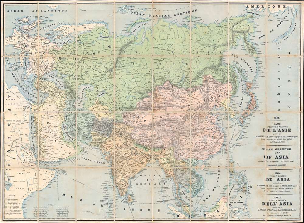
Carte Physique et Politique de l'Asie. Physical and Political Map of Asia Showing British Possessions. Mapa Físico y Político de Asia. Carta Fisica y Politica dell'Asia.
1888 (dated) 28.5 x 39 in (72.39 x 99.06 cm) 1 : 12672000
1888 (dated) 28.5 x 39 in (72.39 x 99.06 cm) 1 : 12672000
Description
This is an 1888 Jean Dosseray map of Asia, published at the height of the Great Game. Dosseray's map broadly covers all of Asia. It is titled in French, English, Spanish, and Italian, suggesting he intended it for a pan-European audience. Regions are identified by a mix of local and Western names, with tribes referenced in certain areas, suggesting a remarkable level of ethnic sensitivity for the period.
Historical Context
The late 19th century was a tense era for global relations between the British and the Russians in Central Asia, with both powers continually expanding their 'spheres of influence'. Britain feared Russian advances into Khiva and Bukhara (the yellow region just above Afghanistan). The rail networks in western Russia snaking toward the Caspian Sea and the British rail network expanding north from Calcutta (Kolkata) northwest into the Punjab and the border with Afghanistan reinforce this reality.The Great Game
'The Great Game' was a diplomatic confrontation between the British and Russian Empires over Afghanistan and other territories in Central and Southern Asia. The conflict, rooted in long-standing animosity between Russia and Britain, revolved around Afghanistan, which, while lacking significant resources of its own, was strategically situated. For its part, Russia feared Britain was making commercial and military inroads into Central Asia, an area long within the sphere of influence of St. Petersburg. Britain, conversely, feared Russia making gains in India, 'the jewel in the crown' of British Asia. The escalating tensions led to several wars and proxy wars: The First Anglo-Afghan War (1839 - 1842), the First Anglo-Sikh War (1845 - 1846), the Second Anglo-Sikh War (1848 - 1849), and the Second Anglo-Afghan War (1878 - 1880), along with the Russian annexations of Khiva, Bukhara, and Kokand. Then as now, Afghanistan proved a grinding stone upon which the world's great empires diminished themselves, none achieving a definitive victory despite committing staggering resources. The Great Game 'ended' on September 10, 1895, with the signing of the Pamir Boundary Commission Protocols, which stabilized the border between Afghanistan and the Russian Empire - but well into the 20th century the British were well aware the conflict remained. Regarding the attitude of Afghans to the British and to the Russians, the general assumption of the British was that 'Some will fight for us, some against us, but all will fight.'Publication History and Census
This map was created and published by Jean Dosseray in 1888. This is the only known cataloged example.Cartographer
Jean Dosseray (1868 - 1904) was a Belgian publisher and editor active in Brussels during the late 19th century. He published science-based maps for schools and tourists. More by this mapmaker...
Condition
Very good. Light soiling. Dissected and mounted on linen in thirty-two (32) panels.