Digital Image: 1840 Ritter Map of Bhutan, N. Burma, N. Bangladesh, Assam, Arunachal Pradesh
AssamOstBengalen-ritter-1840_d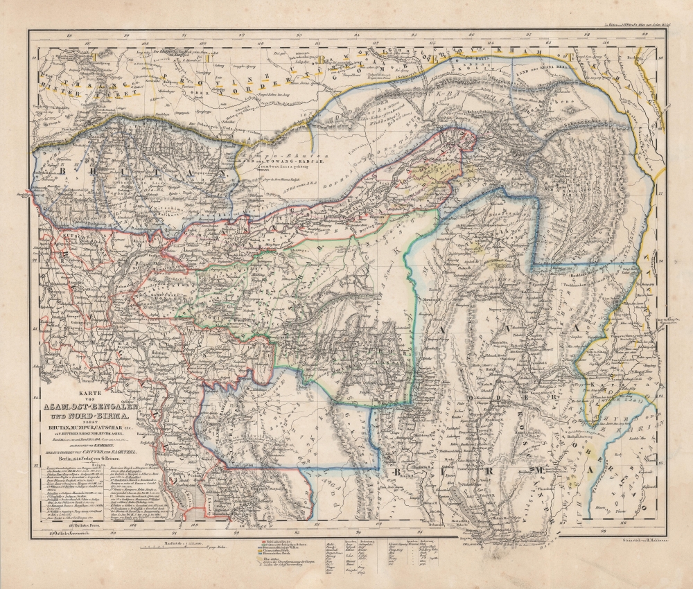

Title
Karte von Asam, Ost-Bengalen und Nort-Birma Nebst Bhutan, Munipur, Catschar, etc.
1840 (dated) 16.25 x 19.25 in (41.275 x 48.895 cm) 1 : 2275000
1840 (dated) 16.25 x 19.25 in (41.275 x 48.895 cm) 1 : 2275000
Description
FOR THE ORIGINAL ANTIQUE MAP, WITH HISTORICAL ANALYSIS, CLICK HERE.
Digital Map Information
Geographicus maintains an archive of high-resolution rare map scans. We scan our maps at 300 DPI or higher, with newer images being 600 DPI, (either TIFF or JPEG, depending on when the scan was done) which is most cases in suitable for enlargement and printing.
Delivery
Once you purchase our digital scan service, you will receive a download link via email - usually within seconds. Digital orders are delivered as ZIP files, an industry standard file compression protocol that any computer should be able to unpack. Some of our files are very large, and can take some time to download. Most files are saved into your computer's 'Downloads' folder. All delivery is electronic. No physical product is shipped.
Credit and Scope of Use
You can use your digial image any way you want! Our digital images are unrestricted by copyright and can be used, modified, and published freely. The textual description that accompanies the original antique map is not included in the sale of digital images and remains protected by copyright. That said, we put significant care and effort into scanning and editing these maps, and we’d appreciate a credit when possible. Should you wish to credit us, please use the following credit line:
Courtesy of Geographicus Rare Antique Maps (https://www.geographicus.com).
How Large Can I Print?
In general, at 300 DPI, you should at least be able to double the size of the actual image, more so with our 600 DPI images. So, if the original was 10 x 12 inches, you can print at 20 x 24 inches, without quality loss. If your display requirements can accommodate some loss in image quality, you can make it even larger. That being said, no quality of scan will allow you to blow up at 10 x 12 inch map to wall size without significant quality loss. For more information, it is best consult a printer or reprographics specialist.
Refunds
If the high resolution image you ordered is unavailable, we will fully refund your purchase. Otherwise, digital images scans are a service, not a tangible product, and cannot be returned or refunded once the download link is used.
Cartographer S
Carl Ritter (August 7, 1779 - September 28, 1859) was a German geographer. Born in Quedlinburg, Ritter attended the Schnepfenthal Salzmann School from the age of five. This school, which focused on the study of nature, would influence Ritter for the rest of his life. Ritter was introduced to Bethmann Hollweg, a banker from Frankfurt, after he graduated. Hollweg soon arranged for Ritter to tutor his children, in exchange for which Ritter would attend the University of Halle at Hollweg's expense. Ritter began tutoring Hollweg's children in 1798 and continued to do so for the following fifteen years. He even spent 1814 - 1819 in Göttingen to continue this work, which is also when Ritter began to devote himself exclusively to the study of geography. He also married his wife Lilli Kramer and wrote the first two volumes of his masterwork, Erdkunde, during his time in Göttingen. Ritter was named professor of history at the University of Frankfurt in 1819 and gained a position in the history department at the University of Berlin the following year. Ritter received his doctorate from the University of Berlin in 1821 and was appointed the first professor of geography there in 1825. He was elected to the Prussian Academy of Sciences in 1822 and became a corresponding member of the Société Asiatique de Paris two years later. Ritter founded the Berlin Geographical Society (Gesellschaft für zu Berlin) in 1828 and in 1849 was elected a Foreign Honorary Member of the American Academy of Arts and Sciences. He was appointed curator of the Royal Cartographic Institute of Prussia in 1856 and died in Berlin in 1859. His masterwork, Erdkunde im Verhältnis zur Natur und zur Geschichte des Menschen oder allgemeine, vergleichende Geographie, als sichere Grundlage des Studiums und Unterricts in physicalischen und historischen Wissenschaften, consists of 19 parts and 21 volumes, and is one of the most extensive works of geography written by a single author. More by this mapmaker...
Heinrich Mahlmann (1812 - December 12, 1848) was a German engraver, lithographer, and cartographer based in Berlin. He worked with Carl Ritter (1779 - 1859), Franz August von Etzel (1784 - 1850), and Heinrich Kiepert (1818 - 1899), among others. We have found references to both 'Carl Heinrich Wilhelm Mahlmann' and 'Heinrich Christian Ludwig', some suggesting they were brothers, and both involved in cartography. Which Heinrich is which, however, is unclear. We believe the engraver who signed his work 'H. Mahlmann' is most likely the latter, 'Heinrich Christian Ludwig'. Learn More...
Franz August von Etzel (July 19, 1784 - December 25, 1850) was a Prussian military officer and the first 'Royal Prussian Telegraph Director'. He was born in Bremen to an Irish immigrant family of noble lineage. He initially applied to the Königlichen Ingenieurakademie in Potsdam, but was declined as his Irish noble heritage was not recognized. Instead, he studied pharmaceuticals, but retained a lifelong passion for technology and geography. He traveled to Paris to extend his studied in geography and mining engineering. It was there that he befriended Alexander von Humboldt (1769 - 1859), with whom he maintained a lifelong correspondence. From 1808 to 1810 he ran the 'Zum krönten Schwarzen Adler' pharmacy in Berlin. He joined the Prussian Army in 1810, taking part in the battles of Ligny and Waterloo. His superiors became aware of his geographical interests and assigned him to compile a military-topographical survey of the Rhine Province, which he worked on from 1816 - 1820. He then served as a geodesist. In 1831, back in Berlin, he was appointed to the 'Immediate Commission for the Establishment of the Telegraph'. He was commissioned to build a 550 km long optical telegraph line from Berlin to the Rhine Province. He also developed the code system and the procedural instructions for the operation of the telegraph and managed the entire system from 1835 as 'Royal Prussian Telegraph Director'. As such, he dealt intensively with the emerging electromechanical telegraphy, developed the corresponding equipment himself and carried out preparatory work for the introduction of the system in Prussia, which took place while he was still in office. His noble heritage was finally recognized on June 25, 1846, and he changed his name to 'von Etzel'. Unfortunately, in that same year he suffered a stroke, from which he never recovered. He was promoted to Major General before retiring, but died shortly thereafter. Learn More...
References
Rumsey 7925.010.