This item has been sold, but you can get on the Waitlist to be notified if another example becomes available, or purchase a digital scan.
1680 / 1693 Hendrick Doncker Chart of the Atlantic (Triangular Trade)
Atlantic-doncker-1680$1,500.00

Title
Paskaert waer in de graden der breedde over weder zyden vande middellyn wassende soo vergrooten, dat die geproportioneert syn tegen hunne nevenstaende graden der lengde. Vertonende behalven Europaes zuydelyckste een gedeelte vande custen van Africa en America, in't octroy byde H.M.H. Staten Genl. der vereenichde Nederl. ver leent aende Genle. West Indische Comp. t'Amsterdam by Hendrick Doncker boeckverkooper inde Nieubrugh steegh int Stuurmans gereetschap.
1680 (undated) 21 x 24.25 in (53.34 x 61.595 cm) 1 : 15000000
1680 (undated) 21 x 24.25 in (53.34 x 61.595 cm) 1 : 15000000
Description
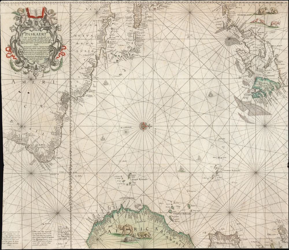
Possibly a singular survivor, this is a rare c. 1680 nautical map of the Atlantic Ocean by Hendrick Doncker. With its clear focus on the Atlantic and the shores facing it, it encompasses the Atlantic Triangle Trade, as it was at the end of the 17th century. We do not see it in surviving examples of Doncker's 1680, 1693, or 1697 sea atlases, and are forced to conclude that it was a separately issued chart.
Bermuda appears, as do the Azores, the Canaries, and the Cape Verde Islands. Newfoundland and the Grand Banks are well-detailed. Near the elegant compass rose is a Maesltrom - the earliest appearance we have seen of this feature, which would be adopted later by De l'Isle, and remain on many maps and charts of the 18th century. As it happens, modern scientists have identified two massive whirlpools in the South Atlantic. While not permanent, these whirlpools are known to last several months before dissipating. It may well be that a report of one of these ephemeral wonders had reached Doncker, as it does not appear on his source, and it does not appear on the otherwise similar Van Keulen chart.
A Closer Look
Oriented to the west, this chart covers from Newfoundland to modern-day Bahia, Brazil, and from the West Indies to the coasts of West Africa and Spain. Much of the chart focuses on those areas most interesting to the 17th-century Dutchman, the Dutch VOC colonies in Nieu-Nederland. Long Island is named (Lange Landt) as is the Hudson (Noort Rivier). New Amsterdam is named, but that is accompanied by the English 'Nieu Yorck,' an odd admission of English presence considering that New England is not named here at all. In Canada, 'Nova Francia' appears, adding weight to the notion that the exclusion of Nova Anglia might have been a deliberate snub.Bermuda appears, as do the Azores, the Canaries, and the Cape Verde Islands. Newfoundland and the Grand Banks are well-detailed. Near the elegant compass rose is a Maesltrom - the earliest appearance we have seen of this feature, which would be adopted later by De l'Isle, and remain on many maps and charts of the 18th century. As it happens, modern scientists have identified two massive whirlpools in the South Atlantic. While not permanent, these whirlpools are known to last several months before dissipating. It may well be that a report of one of these ephemeral wonders had reached Doncker, as it does not appear on his source, and it does not appear on the otherwise similar Van Keulen chart.
A Great Lineage
The map is derived from Blaeu's c. 1621 West-Indische Paskaert, of which Doncker produced an edition of in 1659. (The present work's title is itself drawn from the extended title of Blaeu's work.) As with the West-Indische Paskaert, Doncker's chart is executed on the Mercator Projection, which few other chartmakers of the era understood. This chart is more focused on the Atlantic than its precursor; its westward orientation is almost certainly an effort to most efficiently use the space available in a single folio sheet to digest the much larger original. Thus, the chart clearly presents the coastlines facing both sides of the Atlantic; as such, this is a document of the infamous Triangular Trade, whereby Europeans bought and sold enslaved people from Africa between Europe and the Americas.A Question of Precedence
Doncker's chart is geographically the same as the identically-titled chart produced in 1680 by Johannes van Keulen. The rarity of both of these charts confounds our efforts to determine which of the two provided the source for the other. Van Keulen's version was printed in three known editions - 1680, 1681, and 1702. Certainly, many of Doncker's works were produced later than 1680 - but it must be noted that Van Keulen produced no edition of the West-Indische Paskaert, and that having done so, Doncker was in a better position to have composed the present work; and indeed, many of Van Keulen's other works would derive from Doncker and Van Keulen purchased Doncker's copperplates after the latter's 1699 death.Publication History and Census
This chart was engraved for a separate issue as it appears in none of Hendrick Doncker's sea atlases that we have been able to examine. We see no prior record for this chart in auctions or dealers' records; there is no example cataloged in OCLC. It is, quite possibly, the sole surviving example of the work.CartographerS
Hendrick Doncker (1626 - 1699) (a.k.a. Henri Donker) was a Dutch bookseller and publisher of sea charts and nautical atlases active in Amsterdam during the middle part of the 17th century. He maintained a presence on Nieuwe Brugsteeg, Amsterdam. He married Elizabeth Abrahamsd Rensing in 1647. Doncker was somewhat unique to this period in that he did not copy the work of earlier cartographers, instead producing his own map. Moreover, Doncker's charts were widely admired for their constant revision and overall accuracy. In addition to producing his own charts, he also collaborated with Pieter Goos and Anthonie Jacobsz to producing the pilot guide De Zeespiegel. Following his 1699 death, Doncker's remaining stock and valuable map plates were acquired by Johannes van Keulen. He was survived by a daughter, Anna Doncker. More by this mapmaker...
Willem Janszoon Blaeu (1571 - October 18, 1638), also known as Guillaume Blaeu and Guiljelmus Janssonius Caesius, was a Dutch cartographer, globemaker, and astronomer active in Amsterdam during the late 16th and early 17th centuries. Blaeu was born 'Willem Janszoon' in Alkmaar, North Holland to a prosperous herring packing and trading family of Dutch Reformist faith. As a young man, he was sent to Amsterdam to apprentice in the family business, but he found the herring trade dull and instead worked for his cousin 'Hooft' as a carpenter and clerk. In 1595, he traveled to the small Swedish island of Hven to study astronomy under the Danish Enlightenment polymath Tycho Brahe. For six months he studied astronomy, cartography, instrument making, globe making, and geodesy. He returned to Alkmaar in 1596 to marry and for the birth of his first son, Johannes (Joan) Blaeu (1596 – 1673). Shortly thereafter, in 1598 or 1599, he relocated his family to Amsterdam where he founded the a firm as globe and instrument makers. Many of his earliest imprints, from roughly form 1599 - 1633, bear the imprint 'Guiljelmus Janssonius Caesius' or simply 'G: Jansonius'. In 1613, Johannes Janssonius, also a mapmaker, married Elizabeth Hondius, the daughter of Willem's primary competitor Jodocus Hondius the Elder, and moved to the same neighborhood. This led to considerable confusion and may have spurred Willam Janszoon to adopt the 'Blaeu' patronym. All maps after 1633 bear the Guiljelmus Blaeu imprint. Around this time, he also began issuing separate issue nautical charts and wall maps – which as we see from Vermeer's paintings were popular with Dutch merchants as decorative items – and invented the Dutch Printing Press. As a non-Calvinist Blaeu was a persona non grata to the ruling elite and so he partnered with Hessel Gerritsz to develop his business. In 1619, Blaeu arranged for Gerritsz to be appointed official cartographer to the VOC, an extremely lucrative position that that, in the slightly more liberal environment of the 1630s, he managed to see passed to his eldest son, Johannes. In 1633, he was also appointed official cartographer of the Dutch Republic. Blaeu's most significant work is his 1635 publication of the Theatrum orbis terrarum, sive, Atlas Novus, one of the greatest atlases of all time. He died three years later, in 1638, passing the Blaeu firm on to his two sons, Cornelius (1616 - 1648) and Johannes Blaeu (September 23, 1596 - December 21, 1673). Under his sons, the firm continued to prosper until the 1672 Great Fire of Amsterdam destroyed their offices and most of their printing plates. Willem's most enduring legacy was most likely the VOC contract, which ultimately passed to Johannes' son, Johannes II, who held the position until 1617. As a hobbyist astronomer, Blaeu discovered the star now known as P. Cygni. Learn More...
Condition
Very good. Trimmed to neatline all round, with minimal loss. Original hand color.
References
Not in OCLC, not in Burden.