Digital Image: 1884 Upton and Co. Folding Map of Auckland, New Zealand
AucklandNZ-uptonandco-1884_d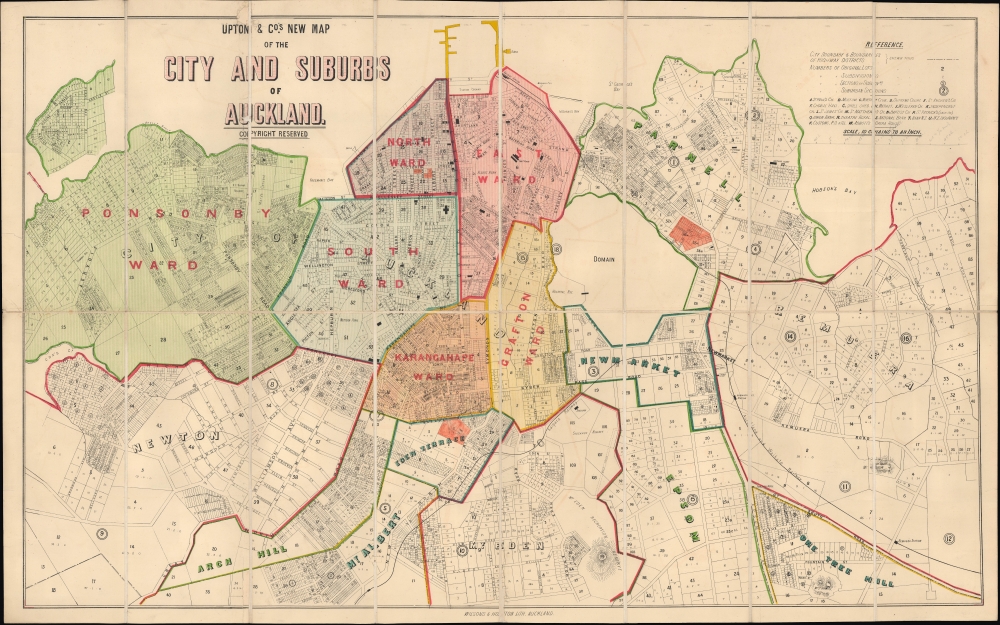


Title
Upton and Co.'s New Map of the City and Suburbs of Auckland.
1884 (undated) 22 x 34.5 in (55.88 x 87.63 cm) 1 : 7920
1884 (undated) 22 x 34.5 in (55.88 x 87.63 cm) 1 : 7920
Description
FOR THE ORIGINAL ANTIQUE MAP, WITH HISTORICAL ANALYSIS, CLICK HERE.
Digital Map Information
Geographicus maintains an archive of high-resolution rare map scans. We scan our maps at 300 DPI or higher, with newer images being 600 DPI, (either TIFF or JPEG, depending on when the scan was done) which is most cases in suitable for enlargement and printing.
Delivery
Once you purchase our digital scan service, you will receive a download link via email - usually within seconds. Digital orders are delivered as ZIP files, an industry standard file compression protocol that any computer should be able to unpack. Some of our files are very large, and can take some time to download. Most files are saved into your computer's 'Downloads' folder. All delivery is electronic. No physical product is shipped.
Credit and Scope of Use
You can use your digial image any way you want! Our digital images are unrestricted by copyright and can be used, modified, and published freely. The textual description that accompanies the original antique map is not included in the sale of digital images and remains protected by copyright. That said, we put significant care and effort into scanning and editing these maps, and we’d appreciate a credit when possible. Should you wish to credit us, please use the following credit line:
Courtesy of Geographicus Rare Antique Maps (https://www.geographicus.com).
How Large Can I Print?
In general, at 300 DPI, you should at least be able to double the size of the actual image, more so with our 600 DPI images. So, if the original was 10 x 12 inches, you can print at 20 x 24 inches, without quality loss. If your display requirements can accommodate some loss in image quality, you can make it even larger. That being said, no quality of scan will allow you to blow up at 10 x 12 inch map to wall size without significant quality loss. For more information, it is best consult a printer or reprographics specialist.
Refunds
If the high resolution image you ordered is unavailable, we will fully refund your purchase. Otherwise, digital images scans are a service, not a tangible product, and cannot be returned or refunded once the download link is used.
Cartographer S
Upton and Company (1864 - 1914) was a bookseller, stationer, and publisher based in Auckland, New Zealand. The company was founded by William Brown Upton (1840 - 1870), a native of Lincolnshire, England who emigrated to New Zealand in 1858, setting up a bookseller shop in 1864. His brother John Henry Upton (1845 - 1929) arrived in Auckland two years later and became his business partner (going by several names, including Upton, Upton Brothers, W. B. and J. H. Upton, and Upton and Co.), which allowed the business to continue after William's untimely death from illness at age 29. Afterwards, the younger Upton managed the business with his brother-in-law William Gorrie (1840 - 1911). John Henry Upton was a busy man who took on many business and civic roles - including director of several companies, chairman of directors of the Bank of New Zealand, and Mayor of Auckland (1890 - 1891) - presumably leaving Gorrie to handle much of the publishing and bookselling. Upton's sons Parker Tasker (1877 - 1955) and Selwyn (1878 - 1922) also became involved in the business and took over management of it in 1909. But the company ran into financial difficulties and was sold to Whitcombe and Tombs (later Whitcoulls) in 1916. More by this mapmaker...
Wilson and Horton (1876 - 2002) was an Auckland, New Zealand-based printer, publisher, and media company, best known for publishing the New Zealand Herald and Auckland Weekly News. The company functioned as a remarkable multigenerational partnership between two families from 1876, when brothers William Scott Wilson and Joseph Liston Wilson (whose father William Chisholm Wilson had founded the New Zealand Herald in 1863) and Alfred George Horton. While newspapers remained their mainstay, the firm also published books and occasionally maps and other media, mostly relating to New Zealand. The company went through several rounds of restructuring in the late 20th century, with the Irish Independent News and Media Group purchasing the Horton portion of the business in 1996, though the name Wilson and Horton continued to be used until 2002. Later, the Australian APN News and Media purchased the New Zealand Herald, continuing to publish a print version down to the present but increasingly focusing on the newspaper's online edition. Learn More...
References
OCLC 949676364.