1928 Terezia and Janos Pictorial Zoological Wall Map of Asia in Hungarian
Azsia-terezia-1928$950.00

Title
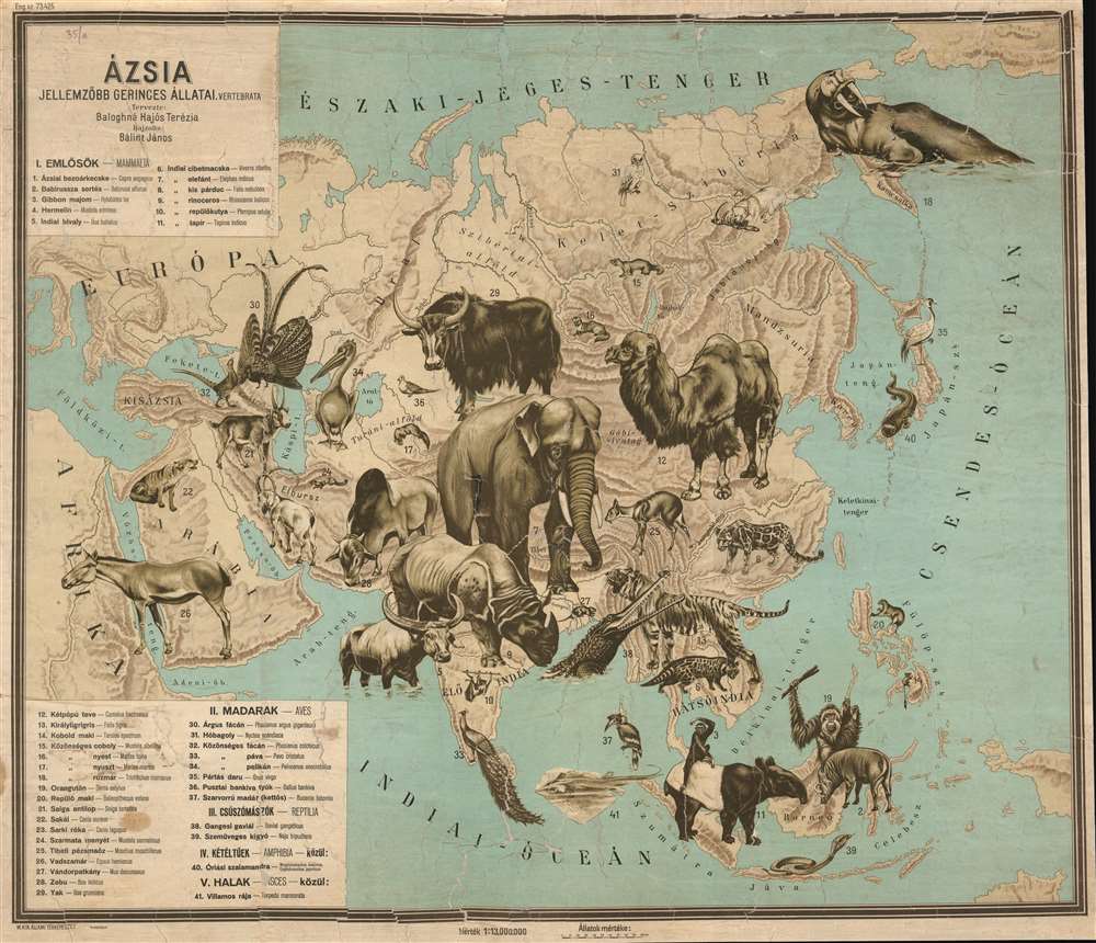
Ázsia. Jellemzöbb Gerinces Állatai.
1928 (undated) 32 x 37.25 in (81.28 x 94.615 cm) 1 : 13000000
1928 (undated) 32 x 37.25 in (81.28 x 94.615 cm) 1 : 13000000
Description
This Baloghné Hajós Terézia and Bálint János' 1928 Hungarian language pictorial zoological wall map of Asia.
A Closer Look
The focus here is zoology, with 33 Asian animals dramatically illustrated. These include an elephant, tiger, Bactrian camel, walrus, water buffalo, crocodile, peacock, cobra, orangutan, rhinoceros, and giant salamander. While Asian political geography is sidelined, a handful of countries, including Korea, India, the Philippines, and Tibet, are referenced. A table in the lower left divides the animals into mammals, birds, and reptiles.Publication History and Census
This map was designed by Baloghné Hajós Terézia and drawn by Bálint János c. 1928. It was printed by the Magyar Királyi Állami Térképészet, or Royal Hungarian State Cartography. We have good reason to believe there are other similar maps covering all continents, but we are aware of surviving examples only of Africa and Asia. In 1928, Terézia issued a zoological atlas incorporating reduced versions of both maps; lacking further evidence, we have followed this date. This is the only example we have identified.Cartographer
Magyar Királyi Állami Térképészet (1867 - 1952), translated 'Royal Hungarian State Cartography,' was a Hungarian government map publishing house active the early 20th centuries. The organization can trace its origins to the Austro–Hungarian Compromise of 1867, which gave Hungary marginal independence with the right to establish its own civil cartography - thus issuing tourist maps, school maps, cadastral plans, etc. More detailed topographical cartography remained under Austrian jurisdiction. This changed in 1918, during World War I, when Hungarian military leadership commissioned Colonel Lajos Hajts (1866 - 1933), professor of the Ludovika Military Academy, to lay the framework for a Hungarian State Cartography. This led to the formation on February 4, 1919, of the Hungarian Military Mapping Group (Magyar Katonai Térképező). This organization was based on the Austrian Militärgeographisches Institut model. The name changed in 1922 to Magyar Királyi Katonai Állami Térképészet (Royal Hungarian State Mapping Institute). In 1938, the name again changed, this time to the Magyar Királyi Honvéd Térképészeti Intézet (Royal Hungarian Institute of Military Cartography). The the Honvéd Térképészeti Intézet was folded into the Soviet-style Ministry of Defense in 1952. More by this mapmaker...
Condition
Average. Map has been stabilized and laid down on pH neutral paper, but exhibits soiling, cracking, some loss, infill and edge damage. Still, the map is so dramatic it presents well.