1897 Garcia Cubas and Vega Map of Baja California, Mexico
BajaCalifornia-garciacubas-1897$800.00

Title
Baja California.
1897 (dated) 19 x 15.5 in (48.26 x 39.37 cm) 1 : 3000000
1897 (dated) 19 x 15.5 in (48.26 x 39.37 cm) 1 : 3000000
Description
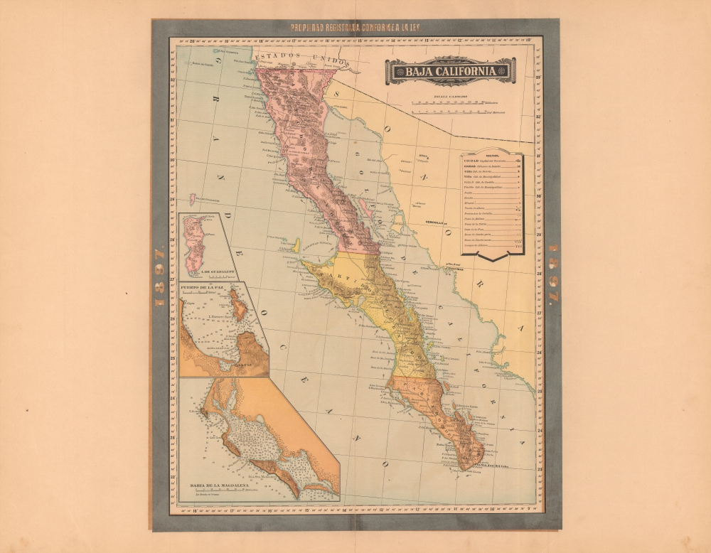
A rare 1897 color lithograph map of the Baja California by Antonio García Cubas and Vega. A year after this map was made, Baja became the seat of one of several revolutions against the government of Porfirio Díaz. Also around this time, major gold discoveries in the Santa Clara Valley fueled the economy of northern Baja.
A Closer Look
Coverage embraces Baja California from Tijuana to Cabo San Lucas, as well as the adjacent Gulf of California. Insets detail the important Bahia de la Magdalena, the Puerto de la Paz, and I. de Guadalupe - this last being something of a mystery as the island is mostly arid and near uninhabited. Roads are noted throughout, although most commerce at the time was maritime. Banks of mother-of-pearl, pearls, and other maritime treasures are noted. Much of the southern peninsula is dominated by orchil production - a rare red dye made from lichen.Publication History and Census
This map was published in Mexico City in 1897 by Vega y Cie. It was printed by Lit. Montauriol Sucs., Mexico City. The map is based on the 1887 work of Antonio García Cubas. It was updated with additional border work for the 1897 issue of theAtlas Geográfico de los Estados Unidos Mexicanos. The atlas is represented in several instructional collections, but extremely scare on the market. The individual maps, likewise, are scarce to the market.Cartographer
Antonio Garcia y Cubas (July 24, 1832 - February 9, 1912) was a Mexican cartographer, writer, engineer, and geographer active in Mexico City in the second half of the 19th and the early 20th centuries. He is considered Mexico's first great geographer. Garcia y Cubas was born in Mexico City. He was orphaned at birth and was raised by is aunt. When he turned 18, he enrolled in the Dirección General de Industria, a government sponsored technical school. There he studied engineering and geography, which he further pursued at the Colegio de San Gregorio, Colegio de Ingenieros. He graduated with honors in geography and from 1856, became a member of the Sociedad Mexicana de Geografía y Estadística. His geographical work earned him the Order of Guadalupe, a Mexican second empire honorific, directly from the Emperor Maximillian. He published several atlases, including his important Atlas Geográfico, Estadístico e Histórico de la República Mexicana, and multiple decorative chromolithograph Atlas Pintoresco e Históricos covering Mexico, Cuba, Spain, and elsewhere. Today his work is scarce and highly desirable. More by this mapmaker...
Source
García Cubas, Antonio, Atlas Geográfico de los Estados Unidos Mexicanos, (Mexico City: Vega) 1897.
Atlas Geográfico de los Estados Unidos Mexicanos is a grand-format folio atlas of Mexico. It is based largely upon the Atlas Geográfico y Estadístico de los Estados Unidos Mexicanos published in 1887 by Antonio García Cubas and Debray. The present atlas incorporates the same maps, but adds a dramatic silver and gold border, which obscures the 1886 García Cubas imprint. It was issued during Porfirio Díaz's third term as president of Mexico - a period marked by rapid expansion of infrastructure and industry, including railroads, mines, bridges, roads, and broad scale electrification and waterworks. The atlases title page in this 1897 edition, celebrates Diaz with a large portrait and dedication. We have identified at least two editions of this atlas, both bearing the 1897 date: one by Cadena y Cie, features a red title page, another by Vega y Cie, featuring a blue title page. All 1897 editions we have identified have the silver borders, but these seem to be overprinted to cover an earlier gold border, with unidentifiable text and dating behind. We have been unable to find any examples with only the gold border. The atlases in general are showpieces of Mexican lithography in the golden age of the Porfiriato.
Condition
Very good. Even overall toning. Centerfold stabilized on verso. Size referenced is the printed map, wide borders add several inches to all sides.
References
cf. Rumsey 5758.029 (1886).