This item has been sold, but you can get on the Waitlist to be notified if another example becomes available, or purchase a digital scan.
1793 Tomás López Map of the Balearic Islands: Ibiza, Majorca, Minorca
Baleares-lopez-1793$1,250.00

Title
Mapa Geografico, y General de Las Islas Baleares Y Pithuyusas.
1793 (dated) 16 x 27.5 in (40.64 x 69.85 cm) 1 : 500000
1793 (dated) 16 x 27.5 in (40.64 x 69.85 cm) 1 : 500000
Description
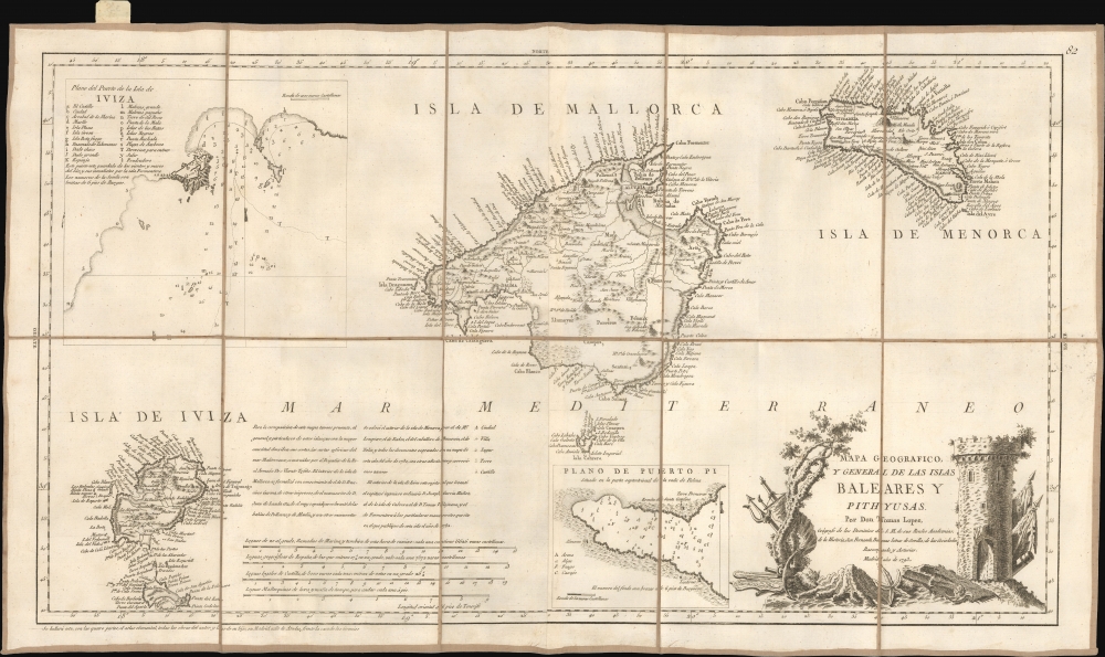
A scarce 1793 separate issue map of the Balearic Islands of Ibiza, Majorca, and Minorca by the Spanish cartographer Tomás López de Vargas Machuca. This map emerged early in the French Revolutionary Wars (1792 - 1802) when the Balearics became increasingly significant as a maritime outpost in the heavily contested western Mediterranean.
A Closer Look
The map has an unusual elongated format centered on Majorca (Mallorca). There are insets of the town of Ibiza (Iviza) and Puerto Pi (Majorca), both with depth soundings. The title cartouche bearing a ruined tower, probably the Sa Dragonera watch tower, appears in the lower right. In the lower left, a note enumerates the cartographic sources consulted in the preparation of this map. The general representation of the Balearic archipelago is based on Vicente Tofiño's chart. For the interior of Mallorca, reference was made to the works of Francisco Garma and Juan de Landaeta, as well as to the map of the bays of Pollensa and Alcudia. The mapping of Menorca's interior draws upon the surveys of Lempiere (Lempriere?), Faden, the Chevalier de Beaurain, and Nolin, supplemented by 'all the documents incorporated into a map of this island from 1780, with additional new corrections and augmentations.' For the interior of Ibiza, the map by José García Muñoz was utilized; for Cabrera, the survey of Tomás Vilajuana; and for Formentera, the manuscripts referenced by Tomás López in his 1782 publication.Historical Context
In 1793, the Balearic Islands - Majorca, Minorca, Ibiza, and Formentera -were part of the Spanish Crown. They took on greater geopolitical significance during this period due to their strategic position in the western Mediterranean. At this time, much of Europe was enmeshed in the French Revolutionary Wars. Although Spain initially joined the First Coalition against Revolutionary France, its naval strength and coastal territories, including the Balearics, were under increasing pressure. Notably, Minorca had only recently been returned to Spanish control 10 years earlier in 1783, after nearly 70 years of intermittent British occupation. Tensions remained high as the British navy sought to reassert influence in the Mediterranean in the face of an increasingly hostile France and an increasingly unstable European mainland. Although the islands remained largely rural and agrarian, fortified ports like Mahón and Palma served as military and trade hubs. Despite being relatively peripheral to the mainland conflicts, the Balearics' proximity to major naval routes and shifting alliances made them a vital and contested maritime outpost.Publication History and Census
This map was compiled by the great Spanish cartographer Tomás López and published in 1793 in Madrid. The present example is a separate issue, but this map was also found in López's Atlas Geografico de Espana, as evidenced by the plate number in the upper right. Rare to the market.Cartographer
Tomás López de Vargas Machuca (1730 - July 19, 1802) was a Spanish cartographer active in the later part of the 18th century. Vargas was born in Toledo and studied mathematics, grammar, and rhetoric at the Colegio Imperial in Madrid. In 1752, with the patronage of the Marquis de la Ensenada, he relocated to Paris to study. López attended the Mazarin College, where he received two courses in Mathematics and lessons in geography from the Abbé de la Caille, Joseph Jérome de Lalande, and Louis Gabriel. He also studied cartography direclty under the legendary French mapmaker Jean Baptiste Bourguignon d'Anville (1697 - 1782). Back in Madrid, he collaborated with the geographer Juan de la Cruz on two educational atlases, published in 1757 and 1758. Around 1770, King Carolos III, appointed him Geógrafo de los Dominios de Su Magestad and gave him charge over the newly created Gabinete de Geografía. In this position, he dedicated the remainder of his life to a detailed mapping of Spain, producing numerous important regional maps, many correcting common mistakes made by foreign geographers. He also ran a private map publishing business in Madrid, first on San Bernardo (1761 - 65), the on Las Carretas (opposite Gamete; 1765 - 1783), and infamy on Atocha (1783 - 1802). He was a member of the Real Academia de San Fernando, the Real Sociedad Bascongada de Amigos del País and the Academia de Bellas Letras de Sevilla. López was succeeded by his two sons, also cartographers, who published several atlases based upon his work. The appraisal of his estate at the time was 489,800 reales (about 1,000,000 USD today), a figure indicative of his success. More by this mapmaker...
Condition
Fine. Dissected and laid on linen. Original linen stable.
References
OCLC 70338772. Rumsey 11510.111.