1634 Blaeu Map of Majorca, Minorca and Ibiza
Balearides-blaeu-1634$1,500.00

Title
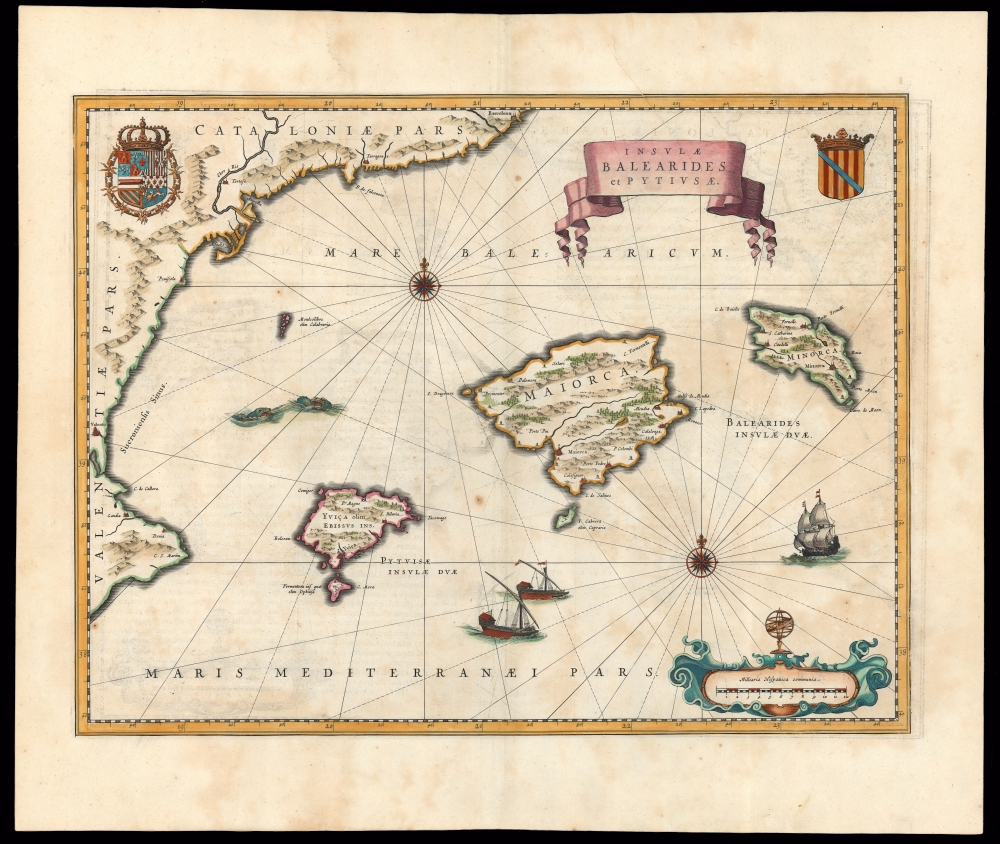
Insulae Balearides et Pytiusae.
1634 (undated) 15 x 19.5 in (38.1 x 49.53 cm) 1 : 980000
1634 (undated) 15 x 19.5 in (38.1 x 49.53 cm) 1 : 980000
Description
This is a beautiful example of Willem Blaeu's 1634 map of Majorca, Minorca, and Ibiza (Ibiça). It is the first folio atlas map dedicated to the Balearic Islands, and the standard for the mapping of the islands in the Dutch Golden Age.
A Closer Look
Majorca, Minorca, Ibiza, and Formentera are presented in detail, with, to a lesser extent, the smaller islands of Cabrera, Dragonera, and Monte Colibre. The coast of Valencia and Catalonia dominates the west part of the map and the sea is presented in the manner of a chart, with two compass roses and rhumb lines. The topography of the islands and the mainland is depicted pictorially, with mountains and forests in profile. Coastal towns are marked, but the interiors are not detailed. The sea is patrolled by two galleys and a sailing ship and two sea monsters prowl the waters north of Ibiza. Other decorations include an elegant title banner, an attractively engraved scale cartouche, and two coats of arms: the arms of Philip II at the upper left, and those of the Kingdom of Majorca at the upper right.The Source
While this is the first map specifically to focus on all three of the main Balearides, it is not the first to show this topography and these placenames. Blaeu's geographical information here is drawn either from Hessel Gerritsz' 1612 four-sheet map of Spain (engraved in 1615 by Pieter van der Keere) or from a manuscript sourced from Gerritsz himself through their mutual connections in the Dutch West India Company. This map served as the standard mapping of the Balearides until the 1683 maps of Mallorcan soldier/scholar Vicente Mut i Armengol (1614 - 1687).Publication History and Census
This map was engraved for inclusion in Willem Blaeu's Theatrum Orbis Terrarum, Sive Atlas Novus, appearing first in the 1634 German edition of that work. It remained in Blaeu atlases until the burning of the firm's offices in 1672. The present example conforms typographically with the 1640 Latin edition of the atlas. The map is well represented in institutional collections in its various editions and appears on the market.CartographerS
Willem Janszoon Blaeu (1571 - October 18, 1638), also known as Guillaume Blaeu and Guiljelmus Janssonius Caesius, was a Dutch cartographer, globemaker, and astronomer active in Amsterdam during the late 16th and early 17th centuries. Blaeu was born 'Willem Janszoon' in Alkmaar, North Holland to a prosperous herring packing and trading family of Dutch Reformist faith. As a young man, he was sent to Amsterdam to apprentice in the family business, but he found the herring trade dull and instead worked for his cousin 'Hooft' as a carpenter and clerk. In 1595, he traveled to the small Swedish island of Hven to study astronomy under the Danish Enlightenment polymath Tycho Brahe. For six months he studied astronomy, cartography, instrument making, globe making, and geodesy. He returned to Alkmaar in 1596 to marry and for the birth of his first son, Johannes (Joan) Blaeu (1596 – 1673). Shortly thereafter, in 1598 or 1599, he relocated his family to Amsterdam where he founded the a firm as globe and instrument makers. Many of his earliest imprints, from roughly form 1599 - 1633, bear the imprint 'Guiljelmus Janssonius Caesius' or simply 'G: Jansonius'. In 1613, Johannes Janssonius, also a mapmaker, married Elizabeth Hondius, the daughter of Willem's primary competitor Jodocus Hondius the Elder, and moved to the same neighborhood. This led to considerable confusion and may have spurred Willam Janszoon to adopt the 'Blaeu' patronym. All maps after 1633 bear the Guiljelmus Blaeu imprint. Around this time, he also began issuing separate issue nautical charts and wall maps – which as we see from Vermeer's paintings were popular with Dutch merchants as decorative items – and invented the Dutch Printing Press. As a non-Calvinist Blaeu was a persona non grata to the ruling elite and so he partnered with Hessel Gerritsz to develop his business. In 1619, Blaeu arranged for Gerritsz to be appointed official cartographer to the VOC, an extremely lucrative position that that, in the slightly more liberal environment of the 1630s, he managed to see passed to his eldest son, Johannes. In 1633, he was also appointed official cartographer of the Dutch Republic. Blaeu's most significant work is his 1635 publication of the Theatrum orbis terrarum, sive, Atlas Novus, one of the greatest atlases of all time. He died three years later, in 1638, passing the Blaeu firm on to his two sons, Cornelius (1616 - 1648) and Johannes Blaeu (September 23, 1596 - December 21, 1673). Under his sons, the firm continued to prosper until the 1672 Great Fire of Amsterdam destroyed their offices and most of their printing plates. Willem's most enduring legacy was most likely the VOC contract, which ultimately passed to Johannes' son, Johannes II, who held the position until 1617. As a hobbyist astronomer, Blaeu discovered the star now known as P. Cygni. More by this mapmaker...
Hessel Gerritsz (1581 – September 4, 1632) was a Dutch engraver, cartographer, and publisher active in Amsterdam during the late 16th and early 17th centuries, among the most preeminent Dutch geographers of the 17th century. He was born in Assum, a town in northern Holland in 1581. As a young man he relocated to Alkmaar to accept an apprenticeship with Willem Jansz Blaeu (1571-1638). He followed Blaeu to Amsterdam shortly afterwards. By 1610 he has his own press, but remained close to Blaeu, who published many of his maps. In October of 1617 he was appointed the first official cartographer of the Vereenigde Oost-Indische Compagnie (Dutch East Indian Company) or VOC. This strategic position offered him unprecedented access to the most advanced and far-reaching cartographic data of the Dutch Golden Age. Unlike many cartographers of his period, Gerritsz was more than a simple scholar and showed a true fascination with the world and eagerness to learn more of the world he was mapping in a practical manner. In 1628 he joined a voyage to the New World which resulted in the production of his seminal maps, published by Joannes de Laet in his 1630 Beschrijvinghe van West-Indien; these would be aggressively copied by both the Blaeu and Hondius houses, and long represented the standard followed in the mapping of the new world. Among his other prominent works are a world map of 1612, a 1613 map of Russia by the brilliant Russian prince Fyodor II Borisovich Godunov (1589 – 1605), a 1618 map of the pacific that includes the first mapping of Australia, and an influential 1630 map of Florida. Gerritsz died in 1632. His position with the VOC, along with many of his printing plates, were taken over by Willem Janszoon Blaeu. Learn More...
Source
Blaeu, W., Théâtre du Monde ou Nouvel Atlas, (Amsterdam: Blaeu) 1640.
The classic Dutch atlas, whose publication ushered in the Dutch golden age of cartography. Willem Jansz Blaeu had been, since 1604, producing engraved maps for sale; these were separate issues (and all consequently extremely rare) until the publishing of Blaeu's Appendix in 1630 and 1631, which also included a number of maps purchased from the widow of Jodocus Hondius, (for example his famous iteration of John Smith's map of Virginia.) In 1634, he announced his intention to produce a new world atlas in two volumes, entitled Theatrum Orbis Terrarum, sive Atlas Novus (Théâtre du Monde ou Nouvel Atlas) (in an effort to invoke the successful work of the same title produced by Ortelius the previous century, while reinforcing the notion of it being a new work.) This work was published first in German in 1634, followed by Latin, Dutch and French editions in 1635. Blaeu's maps have always been noted for the quality of their paper, engraving and fine coloring, and this was the intent from the very start. The 1634 announcement of the upcoming work described it: 'All editions on very fine paper, completely renewed with newly engraved copperplates and new, comprehensive descriptions.' (van der Krogt, p,43) Many of the most beautiful and desirable maps available to the modern collector were printed and bound in Blaeu's atlases. Willem's son, Joan, would go on to add further volumes to the Atlas Novus, concurrently printing new editions of the first two volumes with additional maps, in effect making these new editions an entirely new book. Under Joan there would be nine Latin editions, twelve French, at least seven Dutch, and two German. This exceedingly successful work would be the mainstay of the Blaeu firm until 1661, at which point the work was supplanted by Joan Blaeu's masterwork Atlas Maior in 1662.
Condition
Very good. Faint offsetting and toning, few spots, else a lovely example.
References
OCLC 551937965. Rumsey 10017.589 (1665). Van der Krogt, P. C. J., Koeman's Atlantes Neerlandici, (Vol 2), 6280:2.