Digital Image: 1674 Ligon Map of Barbados (French Edition of the first map of Barbados)
Barbados-ligon-1674-2_d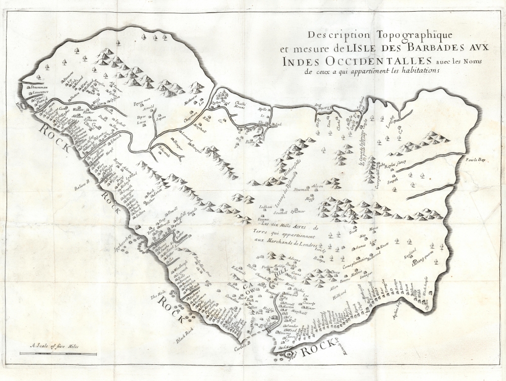

Title
Description Topographique et mesure de LIsle des Barbades aux Indes Occidentalles avec les Noms de ceux a qui appartienent leas habitations.
1674 (undated) 15 x 21 in (38.1 x 53.34 cm) 1 : 100000
1674 (undated) 15 x 21 in (38.1 x 53.34 cm) 1 : 100000
Description
FOR THE ORIGINAL ANTIQUE MAP, WITH HISTORICAL ANALYSIS, CLICK HERE.
Digital Map Information
Geographicus maintains an archive of high-resolution rare map scans. We scan our maps at 300 DPI or higher, with newer images being 600 DPI, (either TIFF or JPEG, depending on when the scan was done) which is most cases in suitable for enlargement and printing.
Delivery
Once you purchase our digital scan service, you will receive a download link via email - usually within seconds. Digital orders are delivered as ZIP files, an industry standard file compression protocol that any computer should be able to unpack. Some of our files are very large, and can take some time to download. Most files are saved into your computer's 'Downloads' folder. All delivery is electronic. No physical product is shipped.
Credit and Scope of Use
You can use your digial image any way you want! Our digital images are unrestricted by copyright and can be used, modified, and published freely. The textual description that accompanies the original antique map is not included in the sale of digital images and remains protected by copyright. That said, we put significant care and effort into scanning and editing these maps, and we’d appreciate a credit when possible. Should you wish to credit us, please use the following credit line:
Courtesy of Geographicus Rare Antique Maps (https://www.geographicus.com).
How Large Can I Print?
In general, at 300 DPI, you should at least be able to double the size of the actual image, more so with our 600 DPI images. So, if the original was 10 x 12 inches, you can print at 20 x 24 inches, without quality loss. If your display requirements can accommodate some loss in image quality, you can make it even larger. That being said, no quality of scan will allow you to blow up at 10 x 12 inch map to wall size without significant quality loss. For more information, it is best consult a printer or reprographics specialist.
Refunds
If the high resolution image you ordered is unavailable, we will fully refund your purchase. Otherwise, digital images scans are a service, not a tangible product, and cannot be returned or refunded once the download link is used.
Cartographer
Richard Ligon (1585 - 1662) was an English businessman, author, polymath, and rake. Ligon was born into an elite royalist family, but lost his fortunes in the English Civil War (1642 - 1651). Ligon was 'the fourth son of a third son' and so inherited 'a respectable name but diluted fortune.' (Parker 39-40). Mired in debt and beset on all side by enemies, Ligon determined to make his fortune in the New World. In 1647, at 60 years of age, he left for the colony of Barbados, acquiring a half-share in a sugar plantation. After two years in the tropical climate, he acquired a persistent fever - likely malaria -, returning to England to recover. Back home, he was immediately arrested by his creditors. While in prison, he complied his notes from Barbados into an important work, A True and Exact History of the Island of Barbadoes, featuring the first specific map of that island. The work was popular, and published in 1657 and again in 1673, before being translated into French for a 1674 edition. The work provides a valuable first-person perspective on the Caribbean sugar trade, the early days of the Sugar Revolution, and 17th century European life in the West Indies. More by this mapmaker...
Source
Justel, H., Recueil De Divers Voyages Faits En Afrique et En l'Amerique , Qui N'ont Point Este Encore Publiez; Contenant L'origine, Les Moeurs, Les Coutumes et Le Commerce Des Habitans De Ces Deux Parties Du Monde, (Paris: Louis Billaine) 1674.
References
OCLC 494842419. Bibliothèque Nationale de France, GE BB-565 (14,103). Huntington Library, #280365.