1817 Thomson Map of Belgium and Luxemboug
Belgium-thomson-1817$200.00

Title
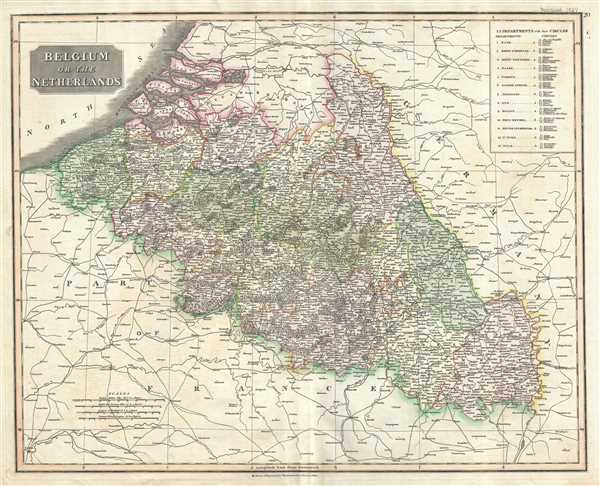
Belgium or the Netherlands.
1817 (undated) 20 x 25 in (50.8 x 63.5 cm) 1 : 820000
1817 (undated) 20 x 25 in (50.8 x 63.5 cm) 1 : 820000
Description
This is a beautiful 1817 map of Belgium and Luxembourg by the Edinburgh cartographer John Thomson. The title ‘The Netherlands’ refers to the old name for Belgium, also called Royal Netherlands and Catholic Netherlands. Covers the region from Dutch Flanders to Germany. This highly detailed map notes several cities, rivers, roads and other physical and political features. Forests are beautifully rendered in profile. An index in the top right quadrant lists the 13 departments of the First French Republic color-coded in the map.
In 1830 Belgian Revolution would create the modern Belgian state. Luxembourg would be considered a province of the new Belgian state. The Netherlands however, would refuse to recognize the new country of Belgium until the 1839 Treaty of London. This Treaty would also grant Luxembourg the status of Grand Duchy, while its western portion would be ceded to Belgium as a province. In 1842, the Grand Duchy of Luxembourg would become part of the German Customs Union.
This map was prepared by John Thomson for inclusion in the 1817 edition of Thomson's New General Atlas.
Cartographer
John Thomson (1777 - c. 1841) was a Scottish cartographer, publisher, and bookbinder active in Edinburgh during the early part of the 19th century. Thomson apprenticed under Edinburgh bookbinder Robert Alison. After his apprenticeship, he briefly went into business with Abraham Thomson. Later, the two parted ways, John Thomson segueing into maps and Abraham Thomson taking over the bookbinding portion of the business. Thomson is generally one of the leading publishers in the Edinburgh school of cartography, which flourished from roughly 1800 to 1830. Thomson and his contemporaries (Pinkerton and Cary) redefined European cartography by abandoning typical 18th-century decorative elements such as elaborate title cartouches and fantastic beasts in favor of detail and accuracy. Thomson's principle works include Thomson's New General Atlas, published from 1814 to 1821, the New Classical and Historical Atlas of 1829, and his 1830 Atlas of Scotland. The Atlas of Scotland, a work of groundbreaking detail and dedication, would eventually bankrupt the Thomson firm in 1830, at which time their plates were sequestered by the court. The firm partially recovered in the subsequent year, allowing Thomson to reclaim his printing plates in 1831, but filed again for bankruptcy in 1835, at which time most of his printing plates were sold to A. K. Johnston and Company. There is some suggestion that he continued to work as a bookbinder until 1841. Today, Thomson maps are becoming increasingly rare as they are highly admired for their impressive size, vivid hand coloration, and superb detail. More by this mapmaker...
Source
Thomson, J., A New General Atlas, (Edinburgh) 1817.
Thomson's New General Atlas was first published in 1817 and continued to be published until about 1821. This is the first of Thomson's major cartographic works and the atlas for which is most celebrated. The New General Atlas follows in the Edinburgh School, which eschews excessive decoration in favor of a more minimalistic fact-based cartographic vision, as established by John Pinkerton, Laurie and Whittle, John Cary, and others in the previous decades. The maps are notable for their massive scale, heavy stock, elegant color work, and easy-to-read typefaces. Although the atlas stopped being published after 1821, Thomson continued to offer 'supplementary' maps that could be tipped into the atlas as late as 1830, when he declared bankruptcy. The maps in the Thomson Atlas were engraved by Thomas Clerk, William Dassauville, Nathaniel Rogers Hewitt, James Kirkwood, Robert Kirkwood, John Menzies, George Menzies, Edward Mitchell, John Moffatt, Samuel John Neele, Robert Scott, and James Wyld.
Condition
Very good. Minor wear and verso repair along original centerfold. Original platemark visible. Overall toning and foxing at places.
References
Rumsey 1007.021.