1890 Burleigh View of Bennington, Vermont
BenningtonView-burleigh-1890$500.00


Title
Bennington, VT. / Folded bird's-eye view of Bennington, VT. showing all points of interest.
1890 (undated) 12.5 x 28.75 in (31.75 x 73.025 cm)
1890 (undated) 12.5 x 28.75 in (31.75 x 73.025 cm)
Description
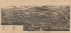
A c. 1890 bird's-eye view of Bennington, Vermont by Lucien Rinaldo Burleigh. It was likely published to coincide with the completion of the Bennington Battle Monument, which celebrated the American victory at the Battle of Bennington in 1777.
To the left of the monument is the site of the Catamount Tavern, which had burned down in 1871. Built in 1769, it was an important building in Vermont's early history, including serving as the site where the Green Mountain Boys planned their attack on Fort Ticonderoga.
Other notable structures are indicated throughout, including train stations, mills, and churches. The large building below the monument is numbered but not listed in the index. It was the Bennington Woolen Works, an impressive structure that still stands, part of the National Register of Historic Places. In front of the Woolen Works is the Bennington and Rutland Railroad, the tracks of which were recently removed and the route renovated to make a bicycle and pedestrian path.
Baum's force was soundly defeated, along with Lieutenant Colonel Heinrich von Breymann's force, which had been sent to reinforce Baum's troops. The battle was a major strategic victory for the American cause. Burgoyne's army was reduced by almost 1,000 men (207 killed, 700 captured, 4 cannon lost), his Native American support largely abandoned him, and he was deprived of desperately-needed supplies. All of these factors led to Burgoyne's defeat and surrender at Saratoga, which directly led to France joining the war.
As the centennial of the battle approached, a local historical society sought for ways to commemorate the battle and the idea of an obelisk gained traction. An ambitious undertaking, the tower stands 306-feet tall, still higher than any building in Vermont and in northern New England more broadly. It was completed by 1889, but was not officially dedicated until 1891, when a ceremony could be arranged that could be attended by the President.
City views were being produced in the United States as early as the 1830s, but the genre exploded after the American Civil War (1861 - 1865). Bridging the gap between maps and pictures, most 19th century American bird's-eye views presented cities to the public from high vantage points. Some were imagined, but others were drawn from hot-air balloons or nearby hills. The presentation, combining high elevation, commercial interest, and new printing technology, created a uniquely American art form, as described by historian Donald Karshan,
A Closer Look
Oriented towards the west, this view takes in the town of Bennington, with the Battle Monument standing prominently in the background. The site of the battle itself - which actually took place 10 miles away, across the border in Walloomsac, New York - sits further in the background at right. At right-center near the Veteran's Home, tents for West Point Cadets and the Governor, along with a triumphal arch and review stand at left, all suggest that this view was published in tandem with the dedication ceremony for the Battle Monument, held in 1891 and attended by President Benjamin Harrison.To the left of the monument is the site of the Catamount Tavern, which had burned down in 1871. Built in 1769, it was an important building in Vermont's early history, including serving as the site where the Green Mountain Boys planned their attack on Fort Ticonderoga.
Other notable structures are indicated throughout, including train stations, mills, and churches. The large building below the monument is numbered but not listed in the index. It was the Bennington Woolen Works, an impressive structure that still stands, part of the National Register of Historic Places. In front of the Woolen Works is the Bennington and Rutland Railroad, the tracks of which were recently removed and the route renovated to make a bicycle and pedestrian path.
The Battle of Bennington
The Battle of Bennington took place during the American Revolutionary War and was part of the Saratoga campaign. A force of about 2,000 rebels, led by General John Stark, engaged and decisively defeated a detachment of General John Burgoyne's army. Led by Lieutenant Colonel Friedrich Baum, this force, primarily made up of Hessians, was deployed by General Burgoyne to capture a supply depot at Bennington, Vermont, believing the depot to be poorly defended. Burgoyne, who had been marching from Montreal, faced the problem of ever-lengthening supply lines, and was low on rations.Baum's force was soundly defeated, along with Lieutenant Colonel Heinrich von Breymann's force, which had been sent to reinforce Baum's troops. The battle was a major strategic victory for the American cause. Burgoyne's army was reduced by almost 1,000 men (207 killed, 700 captured, 4 cannon lost), his Native American support largely abandoned him, and he was deprived of desperately-needed supplies. All of these factors led to Burgoyne's defeat and surrender at Saratoga, which directly led to France joining the war.
As the centennial of the battle approached, a local historical society sought for ways to commemorate the battle and the idea of an obelisk gained traction. An ambitious undertaking, the tower stands 306-feet tall, still higher than any building in Vermont and in northern New England more broadly. It was completed by 1889, but was not officially dedicated until 1891, when a ceremony could be arranged that could be attended by the President.
American Bird's-Eye City Views
The tradition of the bird's-eye city view emerged in the United States in the middle part of the 19th century and coincided with the commercial development of lithographic printing. Before the rise of lithography, the ability to own and display artwork in the home was largely limited to the extremely wealthy, the advent of lithographic printing made it possible for everyone to own visually striking artwork. A robust trade developed in portraits of political leaders, allegorical and religious images, and city views.City views were being produced in the United States as early as the 1830s, but the genre exploded after the American Civil War (1861 - 1865). Bridging the gap between maps and pictures, most 19th century American bird's-eye views presented cities to the public from high vantage points. Some were imagined, but others were drawn from hot-air balloons or nearby hills. The presentation, combining high elevation, commercial interest, and new printing technology, created a uniquely American art form, as described by historian Donald Karshan,
Some print connoisseurs believe that it was only with the advent of the full-blown city-view lithograph that American printmaking reached its first plateau of originality, making a historical contribution to the graphic arts. They cite the differences between the European city-view prints and the expansive American version that reflects a new land and a new attitude toward the land.The vogue for bird's-eye city views lasted from about 1845 to 1920, during which period some 2,400 cities were thus portrayed, some multiple times. Although views were produced in many urban centers, the nexus of view production in the United States was Milwaukee, Wisconsin. The major American viewmakers were Stoner, Wellge, Bailey, Fowler, Hill, Ruger, Koch, Burleigh, Norris, and Morse, among others.
Publication History and Census
This view was by Lucien Rinaldo Burleigh (misspelled here as 'Burligh') around the year 1890, most likely to coincide with the Battle Monument dedication ceremony in 1891. It is based on an 1887 view that included two insets and a more extensive index (explaining the buildings numbered here but not listed in the index and the jump in the index from number 13 to 38). It is noted in the OCLC (dated c. 1905) among the holdings of the Library of Congress and the Vermont Historical Society.Cartographer
Lucian Rinaldo Burleigh (February 6, 1853 – July 30, 1923) was an American lithographer and view maker active in the latter part of the 19th century. Burleigh was born in Plainfield, Connecticut and studied civil engineering at Worcester County Free Institute of Industrial Science (Worcester Polytechnic). There he studied under George E. Gladwin who specialized in field sketching. Burleigh became one of Gladwin's prized students and this no doubt influenced his choice to become a viewmaker. Burleigh's view work stands out for two reasons. One, most of his town views are drawn form a lower than usual point of view enabling him to take greater advantage of profile perspectives. Two, his views do not integrate people or animals – most late 19th century American view artists added horses, people, carts, dogs, and even chickens to their views. Between the years of 1883 and 1885 Burleigh produced some 28 views of New York towns and cities. Most of these were published by either Beck and Pauli of Milwaukee or C. H. Voght of Cleveland. After 1886, Burleigh established his own Troy press and subsequent views were published in-house. Burleigh also worked as a lithographer for other view makers including J. J. Stoner and Albert Ruger, among many others. Burleigh contributed to the production of about 228 lithographic city views and personally drew about 120, marking him one of the most important and influential viewmakers of the 19th century. More by this mapmaker...
Condition
Average. Paper aged. Laid down on archival tissue, to stabilize fold splits.
References
OCLC 76003596.