Digital Image: 1949 Sims Pictorial Map of Germany during the Berlin Airlift
BerlinAirlift-sims-1949_d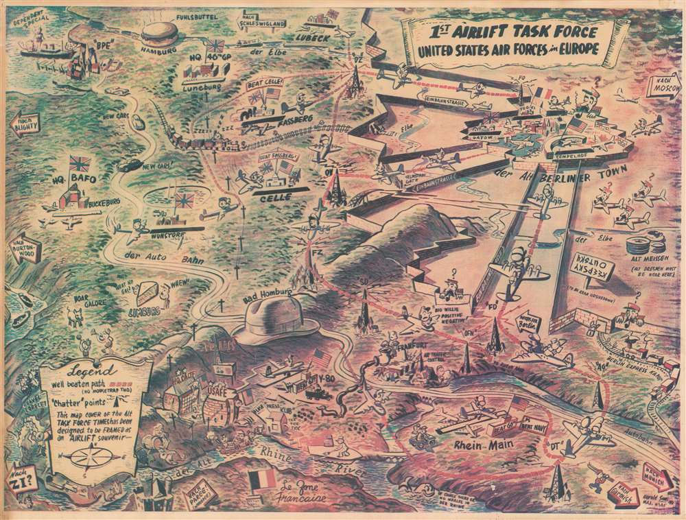

Title
1st Airlift Task Force. United States Air Forces in Europe.
1949 (dated) 13.5 x 17.75 in (34.29 x 45.085 cm)
1949 (dated) 13.5 x 17.75 in (34.29 x 45.085 cm)
Description
FOR THE ORIGINAL ANTIQUE MAP, WITH HISTORICAL ANALYSIS, CLICK HERE.
Digital Map Information
Geographicus maintains an archive of high-resolution rare map scans. We scan our maps at 300 DPI or higher, with newer images being 600 DPI, (either TIFF or JPEG, depending on when the scan was done) which is most cases in suitable for enlargement and printing.
Delivery
Once you purchase our digital scan service, you will receive a download link via email - usually within seconds. Digital orders are delivered as ZIP files, an industry standard file compression protocol that any computer should be able to unpack. Some of our files are very large, and can take some time to download. Most files are saved into your computer's 'Downloads' folder. All delivery is electronic. No physical product is shipped.
Credit and Scope of Use
You can use your digial image any way you want! Our digital images are unrestricted by copyright and can be used, modified, and published freely. The textual description that accompanies the original antique map is not included in the sale of digital images and remains protected by copyright. That said, we put significant care and effort into scanning and editing these maps, and we’d appreciate a credit when possible. Should you wish to credit us, please use the following credit line:
Courtesy of Geographicus Rare Antique Maps (https://www.geographicus.com).
How Large Can I Print?
In general, at 300 DPI, you should at least be able to double the size of the actual image, more so with our 600 DPI images. So, if the original was 10 x 12 inches, you can print at 20 x 24 inches, without quality loss. If your display requirements can accommodate some loss in image quality, you can make it even larger. That being said, no quality of scan will allow you to blow up at 10 x 12 inch map to wall size without significant quality loss. For more information, it is best consult a printer or reprographics specialist.
Refunds
If the high resolution image you ordered is unavailable, we will fully refund your purchase. Otherwise, digital images scans are a service, not a tangible product, and cannot be returned or refunded once the download link is used.
Cartographer
Harold Hilson 'Hal' Sims (December 29, 1912 - August 16, 2002) was an American artist and career military officer. Born in Georgiana, Alabama, live in Montgomery, Alabama, and worked as an artist before joining the U.S. Army Air Corps in 1941. He served in both World War II and the Korean War. During the Berlin Airlift, Sims served as Master Navigator for the Military Air Transport Service (MATS) and also produced designs, illustrati0ons and presentations used during the Airlift. During the Airlift, Sims also served as the editor of the 'Task Force Times', a daily publication for personnel serving with the Airlift command meant to improve communications and morale, as well as stoke friendly competition between the air crews. He also had a 'obne-man' show of his paintings at the Smithsonian National Air and Space Museum in 1953. Sims retired from the military in 1969. After his retirement, Sims devoted his time to his family and his painting and found success as a highly regarded watercolor artist. He married his wife Sybil in 1944 and they were married for fifty-eight years, with whom he had three children. More by this mapmaker...
References
Persuasive Maps: PJ Mode Collection 2221.