This item has been sold, but you can get on the Waitlist to be notified if another example becomes available, or purchase a digital scan.
1949 Sims Pictorial Map of Germany during the Berlin Airlift
BerlinAirlift-sims-1949$375.00

Title
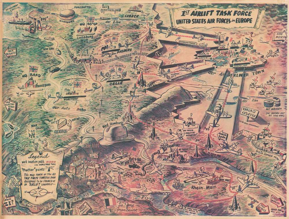
1st Airlift Task Force. United States Air Forces in Europe.
1949 (dated) 13.5 x 17.75 in (34.29 x 45.085 cm)
1949 (dated) 13.5 x 17.75 in (34.29 x 45.085 cm)
Description
This is a rare 1949 Harold H. Sims pictorial map of Germany during the Berlin Airlift. Published as a cover of the 'Alt Task Force Times' and 'designed to be framed as an Airlift souvenir', the entire work paints the tense situation in an amusing light. The Airlift's complex aerial operations are highlighted by drawings of airplanes flown by smiling pilots along red dashed lines, leading to Berlin's three airports: Tegel, Gatow, and Tempelhof. Pictorial icons mark German cities, such as a wedge of cheese for Limburg, a bowler hat marks 'Bad Hamburg,' and a hamburger identifies Hamburg. The 'dependent special' delivers servicemen's wives to a port near Hamburg and 'New Cars!' drive south along 'der Auto Bahn' to the U.S. sector. U.S. Air Forces Europe's headquarters are labeled, along with the bases of both the 60th and 61st Troop Carrier Groups. Signs emblazoned with 'Beat 60th' and 'Beat 61st' announce the friendly rivalry between the Groups. British airbases are labeled as well, although, intriguingly, the colors of the British flag are inverted. Berlin, situated in the upper right quadrant, is surrounded by walls, a visual representation of the blockade. These walls predate the actual Berlin Wall by ten years. Caricatures of Soviets, complete with very Stalin-like mustaches, peer over walls at the crazy hijinks of the Westerners and even have massive question marks over their heads. A sign, to be read upside down, reads, 'Keepsky Outsky,' just in case the walls did not adequately convey that message.
The Berlin Airlift
The Berlin Airlift (June 26, 1948 - September 30, 1949) was an international operation in response to the Berlin Blockade (June 24, 1948 - May 12, 1949). After World War II, the United States, Great Britain, France, and the Soviet Union divided the occupation of Germany and of Berlin itself between themselves. Berlin was situated deep within the Soviet occupation sector. In June 1948, the Soviets blocked all access to the American, British, and French sectors in Berlin in response to the Allied introduction of the new West German Deutsche Mark into the city. The Soviets hoped to either force the withdrawal of the Deutsche Mark or the Western powers from Berlin. In response, American, British, French, Canadian, Australian, New Zealand, and South African aircrews flew over 200,000 sorties to supply West Berliners. During the fifteen months of the operation, 2,334,374 tons of supplies were delivered, over two-thirds of which was coal. The airplanes used in the Airlift flew over 92,000,000 miles, almost the distance from Earth to the Sun, and at its height, an aircraft was landing in West Berlin every thirty seconds.Publication History and Census
This map was created by Harold H. Sims and published by the Task Force Times in 1949. An example is part of Persuasive Maps: The P.J. Mode Collection at Cornell University. We are aware of one example in private hands.Cartographer
Harold Hilson 'Hal' Sims (December 29, 1912 - August 16, 2002) was an American artist and career military officer. Born in Georgiana, Alabama, live in Montgomery, Alabama, and worked as an artist before joining the U.S. Army Air Corps in 1941. He served in both World War II and the Korean War. During the Berlin Airlift, Sims served as Master Navigator for the Military Air Transport Service (MATS) and also produced designs, illustrati0ons and presentations used during the Airlift. During the Airlift, Sims also served as the editor of the 'Task Force Times', a daily publication for personnel serving with the Airlift command meant to improve communications and morale, as well as stoke friendly competition between the air crews. He also had a 'obne-man' show of his paintings at the Smithsonian National Air and Space Museum in 1953. Sims retired from the military in 1969. After his retirement, Sims devoted his time to his family and his painting and found success as a highly regarded watercolor artist. He married his wife Sybil in 1944 and they were married for fifty-eight years, with whom he had three children. More by this mapmaker...
Condition
Very good. Newsprint. Minor closed tear in lower left corner professionally repaired on verso. Blank on verso.
References
Persuasive Maps: PJ Mode Collection 2221.