1630 Blaeu Map of Bermuda
Bermuda-blaeu-1630$3,000.00
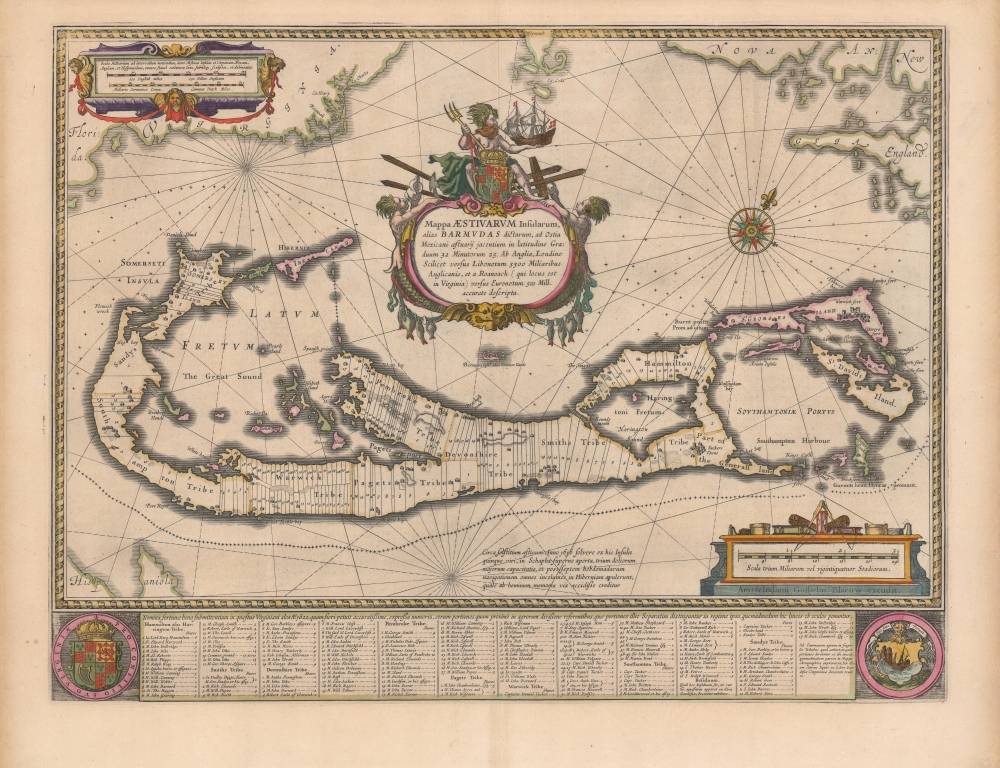

Title
Mappa Aestivarvm Insularum, alias Barmudas.
1630 (undated) 16 x 21 in (40.64 x 53.34 cm) 1 : 3327000
1630 (undated) 16 x 21 in (40.64 x 53.34 cm) 1 : 3327000
Description
This is the classic 17th-century Dutch map of Bermuda: Willem Blaeu's map of the 'Summer Isles', here with superb old color. Engraved in 1630, Blaeu's version of Richard Norwood's chart is the most richly decorative to see print. Moreover, it is a marvel of cartographic design, in fact being two maps, on different scales, superimposed upon one another.
Dominating the image is a map of the Bermuda Islands, showing the parishes and tribes allotted to the Bermuda Company’s shareholders with their names included, most of which persist today as place names. The map illustrates the island's treacherous coastlines with crosses signifying wrecks peppering the surrounding waters. At the bottom, flanked by the Royal Arms of Great Britain and the arms of Bermuda, are a list of Company members with numbers keying them to the map.
The observant reader will note a second, smaller depiction of Bermuda, placed to show the island's position with respect to the North American coastline: near the borders are the easily recognizable coasts of Cape Cod, Nova Scotia, and Virginia. Many later copyists did not understand this design, depicting the island(s) without the context of the mainland in their maps thus showing the smaller 'Bermuda', as a small island off the coast of... Bermuda.
The Source
This map was based on Richard Norwood’s chart, produced in 1618 for the Bermuda Company. Norwood's work provided the dominant depiction of the island of the seventeenth century. Versions of this map were printed by John Speed as well as Blaeu's competitors, Hondius and Jansson.Two Maps in One
In a brilliant moment of inspired design, this piece is two maps, at different scales, superimposed upon one another. The most prominent, 'foreground' map displays Bermuda in detail. The other, 'background' fixes the island's position in relation to the North American east coast.Dominating the image is a map of the Bermuda Islands, showing the parishes and tribes allotted to the Bermuda Company’s shareholders with their names included, most of which persist today as place names. The map illustrates the island's treacherous coastlines with crosses signifying wrecks peppering the surrounding waters. At the bottom, flanked by the Royal Arms of Great Britain and the arms of Bermuda, are a list of Company members with numbers keying them to the map.
The observant reader will note a second, smaller depiction of Bermuda, placed to show the island's position with respect to the North American coastline: near the borders are the easily recognizable coasts of Cape Cod, Nova Scotia, and Virginia. Many later copyists did not understand this design, depicting the island(s) without the context of the mainland in their maps thus showing the smaller 'Bermuda', as a small island off the coast of... Bermuda.
Oh Well, Might As Well Make a Map
Richard Norwood came to Bermuda at the behest of the Bermuda Company, but the notion was not for him to survey the place. Norwood had devised a sort of diving bell, and earlier succeeded in retrieving a cannon from Lymington Harbor, England. The Company hoped to employ Norwood's device to harvest pearls from the oyster beds they believed surrounded the islands. When a wealth of pearls failed to materialize, the Company instead reassigned Norwood to survey the islands. He executed several surveys between 1614 and 1617, resulting ultimately in this map.A Mighty Cartouche
While sharing the geographical details of John Speed's iteration of Norwood's chart, Blaeu's presentation surpasses Speed's in beauty - largely due to the elaborate cartouche gracing the center. It names the islands and describes its dimensions and its location both in latitude and longitude as well as its distance from London and from Roanoke in Virginia. The large, oval cartouche is 'garlanded' with fishes strung on a line, flanked with mer-men, and crowned with the British Royal Arms. Straddling these, a windblown Neptune holds his trident in his right hand and holds aloft a sailing ship in his left. As is appropriate for the dual map, there are two separate scale cartouches: one in the lower right pertaining to the narrowly-focused depiction of Bermuda, and one in the upper left giving the scales in English, Dutch and German miles for the broader sea chart.Publication History and Census
This map was engraved by Willem Blaeu for inclusion in his first atlas in 1630, and it remained in the family's atlases throughout their publication history. This example conforms typographically to the Dutch editions of the Toonneel Des Aerdrycx oft Nieuwe Atlas, printed after 1642. The map in its many editions is well represented in institutional collections. Attractive examples of this quality are growing scarce on the market.CartographerS
Willem Janszoon Blaeu (1571 - October 18, 1638), also known as Guillaume Blaeu and Guiljelmus Janssonius Caesius, was a Dutch cartographer, globemaker, and astronomer active in Amsterdam during the late 16th and early 17th centuries. Blaeu was born 'Willem Janszoon' in Alkmaar, North Holland to a prosperous herring packing and trading family of Dutch Reformist faith. As a young man, he was sent to Amsterdam to apprentice in the family business, but he found the herring trade dull and instead worked for his cousin 'Hooft' as a carpenter and clerk. In 1595, he traveled to the small Swedish island of Hven to study astronomy under the Danish Enlightenment polymath Tycho Brahe. For six months he studied astronomy, cartography, instrument making, globe making, and geodesy. He returned to Alkmaar in 1596 to marry and for the birth of his first son, Johannes (Joan) Blaeu (1596 – 1673). Shortly thereafter, in 1598 or 1599, he relocated his family to Amsterdam where he founded the a firm as globe and instrument makers. Many of his earliest imprints, from roughly form 1599 - 1633, bear the imprint 'Guiljelmus Janssonius Caesius' or simply 'G: Jansonius'. In 1613, Johannes Janssonius, also a mapmaker, married Elizabeth Hondius, the daughter of Willem's primary competitor Jodocus Hondius the Elder, and moved to the same neighborhood. This led to considerable confusion and may have spurred Willam Janszoon to adopt the 'Blaeu' patronym. All maps after 1633 bear the Guiljelmus Blaeu imprint. Around this time, he also began issuing separate issue nautical charts and wall maps – which as we see from Vermeer's paintings were popular with Dutch merchants as decorative items – and invented the Dutch Printing Press. As a non-Calvinist Blaeu was a persona non grata to the ruling elite and so he partnered with Hessel Gerritsz to develop his business. In 1619, Blaeu arranged for Gerritsz to be appointed official cartographer to the VOC, an extremely lucrative position that that, in the slightly more liberal environment of the 1630s, he managed to see passed to his eldest son, Johannes. In 1633, he was also appointed official cartographer of the Dutch Republic. Blaeu's most significant work is his 1635 publication of the Theatrum orbis terrarum, sive, Atlas Novus, one of the greatest atlases of all time. He died three years later, in 1638, passing the Blaeu firm on to his two sons, Cornelius (1616 - 1648) and Johannes Blaeu (September 23, 1596 - December 21, 1673). Under his sons, the firm continued to prosper until the 1672 Great Fire of Amsterdam destroyed their offices and most of their printing plates. Willem's most enduring legacy was most likely the VOC contract, which ultimately passed to Johannes' son, Johannes II, who held the position until 1617. As a hobbyist astronomer, Blaeu discovered the star now known as P. Cygni. More by this mapmaker...
Richard Norwood (c.1590 – 1675) was an English mathematician, diver, and surveyor. He has been called 'Bermuda’s outstanding genius of the seventeenth century'. He had been sent to Bermuda by the Bermuda Company, not initially to survey the islands but to harvest pearls. Norwood had devised an early form of diving bell, with which he had succeeded in retrieving a cannon from Lymington Harbor, England. The Company hoped to employ Norwood's device to harvest pearls from the oyster beds they believed surrounded the islands. When a wealth of pearls failed to materialize, the Company instead reassigned Norwood to survey the islands, and he executed several surveys between 1614 and 1617. These would provide the basis of the dominant printed images of Bermuda of the seventeenth century, first published by Speed in 1622 and copied by Blaeu and Hondius. Despite accusations of collusion with the governor to assign to the governor and himself eight shares of the best land in the islands, he retained a long association with the place. Although he held land patents in Virginia, he does not seem to have ever travelled there, remaining instead in the Bermudas until the 1630s. He primarily made his living at that time in London as a teacher of mathematics, but continued geographical work, producing for example a sophisticated survey of the route between London and York. Using observations of the sun at various latitudes, he produced the most accurate estimation of the length of a degree of the meridian that had ever been done in England: his work would be noted by Newton in his Principia Mathematica. During the English Civil War he returned to Bermuda, there to work underr a government grant as a schoolmaster. He is credited with founding Bermuda's oldest school, Warwick Academy, in 1662; that same year he produced a further survery of the islands. He died at Bermuda in 1675, aged about eighty-five. Learn More...
Source
Blaeu, W. / Blaeu, J., Toonneel Des Aerdrycx oft Nieuwe Atlas, (Amstedam) 1642.
Condition
Excellent. Fine original color. Some light marginal toning, a printers' crease at lower right, else fine.
References
OCLC 1046465765. Rumsey 12202.058 (1630 Appendix issue) Palmer, Map Collectors' Circle CS p. 10. Van der Krogt, P. C. J., Koeman's Atlantes Neerlandici, (3 Vols), 9660:2:221.