This item has been sold, but you can get on the Waitlist to be notified if another example becomes available, or purchase a digital scan.
1847 Lowry / Sharpe Map of the Black Sea Region
BlackSea-lowry-1847$75.00

Title
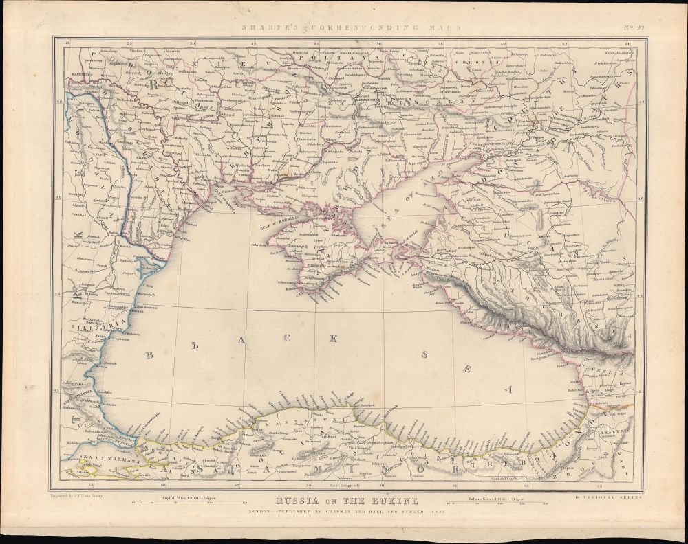
Russia on the Euxine. Sharpe's Corresponding Maps No. 22.
1847 (dated) 13.25 x 16 in (33.655 x 40.64 cm) 1 : 3380000
1847 (dated) 13.25 x 16 in (33.655 x 40.64 cm) 1 : 3380000
Description
This is J. Sharpe's 1847 map of the Black Sea region issued for Sharpe's Corresponding Atlas. It presents 'The Eastern Question', reflecting political tensions related to ongoing wars between the Ottoman and Russian empires.
A Closer Look
Coverage embraces from central Ukraine to Anatolia and from the eastern Balkans to the Caucasus. The map focuses on the Black Sea, noting coastal features (capes, gulfs, islands) along with cities, roads, waterways, areas of elevation, and administrative divisions. Scales in English miles and Russian versts are provided. The map's title refers to the ancient Greek name for the Black Sea.Historical Context
Most of the land seen here had been under the indirect control of the Ottoman Empire, through vassals like the Crimean Khanate and Principality of Moldavia, until the late 18th century. But after a string of wars with European neighbors, especially the Russian Empire, with whom the Ottomans were at war almost continuously from the late 17th through the mid-19th century, Turkish influence declined and Russian influence, if not outright control, increased. In the years preceding this map's publication, the Principality of Moldavia was divided in two, with the eastern half annexed by Russia as Bessarabia (in 1812). In 1828-1829, Russia annexed further territory in the Caucasus and in the Danube River Delta, while Moldavia and Wallachia became protectorates of the Tsar's government, though here they continue to be labeled as 'Turkey'. (Serbia and Greece had also become independent of Ottoman rule in the meantime.) The continued difficulties of the Ottomans and the expansionism of the Russian Empire was a major diplomatic and geopolitical conundrum in 19th century Europe, known simply as the 'Eastern Question,' and was a major contributing factor to the Crimean War (1853 - 1856), which began within a decade of this map's publication.Publication History and Census
This map was engraved by Joseph Wilson Lowry and appeared in Sharpe's Corresponding Atlas, published by Chapman and Hall, best known as publishers of atlases by the Society for the Diffusion of Useful Knowledge.CartographerS
Joseph Wilson Lowry (October 7, 1803 – June 15, 1879) was an English engraver active in London during middle to later 19th century. Joseph was the son of Wilson Lowry (1760 – 1824), also an engraver under whom he apprenticed. Lowry produced numerous important maps for other publishers and even introduced his own atlas, Lowry's Table Atlas, in 1852. He was appointed engraver to the Geological Survey of Great Britain and Ireland. More by this mapmaker...
Chapman and Hall (fl. 1830 - present) was a British publishing house in London, founded in 1830 by Edward Chapman and William Hall. Upon Hall's death in 1847, Chapman's cousin Frederic Chapman became partner in the company, of which he became sole manager upon the retirement of Edward Chapman in 1864. In 1868 author Anthony Trollope bought a third of the company for his son, Henry Merivale Trollope. From 1902 to 1930 the company's managing director was Arthur Waugh. In the 1930s the company merged with Methuen, a merger which, in 1955 participated in forming the Associated Book Publishers. The latter was acquired by The Thomson Corporation in 1987. Chapman and Hall was sold again in 1998 as part of Thomson Scientific and Professional to Wolters Kluwer, who sold on its well-regarded mathematics and statistics list to CRC Press. Today the name of Chapman and Hall/CRC is used as an imprint for science and technology books by Taylor and Francis, part of the Informa group since 2004. The company is best known for its publication of the works of Charles Dickens (from 1840 until 1844 and again from 1858 until 1870), William Thackeray, Elizabeth Barrett Browning, Eadweard Muybridge and Evelyn Waugh. They continued to publish hitherto unpublished Dickens material well into the 20th century. In cartographic circles they are known as the primary publishers of the Society for the Diffusion of Useful Knowledge Atlas, a massive 200+ map atlas that was popular in England during the mid-19th century. Learn More...
Source
Sharpe, J., Sharpe's Corresponding Atlas, Comprising Fifty-Four Maps (London: Chapman and Hall, 1947).
Condition
Very good. Light foxing.
References
Rumsey 2175.023.