This item has been sold, but you can get on the Waitlist to be notified if another example becomes available, or purchase a digital scan.
1868 Crafts City Plan or Map of Boston, Massachusetts
Boston-crafts-1868$750.00

Title
Plan of Boston.
1868 (dated) 34.25 x 53 in (86.995 x 134.62 cm) 1 : 6000
1868 (dated) 34.25 x 53 in (86.995 x 134.62 cm) 1 : 6000
Description
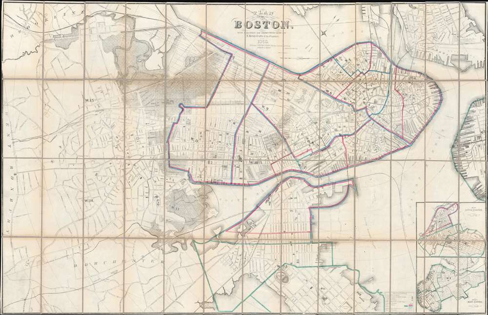
The Boston City Engineer's Office produced this 1868 city plan or map of Boston. Depicting all the city of Boston, including the Roxbury, which was annexed into Boston January 5, 1868, shortly before this map went to press. Insets of South Boston and East Boston are situated on the bottom right. The color coding on the map refers to school districts with red indicating boy's schools, blue girl's schools, and green co-educational schools. As the most up to date official map of Boston, this map provided the base cartography for numerous subsequent commercial maps, including those issued by A. J. Johnson and Samuel Augustus Mitchell Jr.
A New Series of Maps of Boston
Nancy S. Seashoales in her book, Gaining Ground: A History of Landmaking in Boston provides an exciting history of the present map.[…] That year [1860] the City Council decided to have a new 500-scale map of the city prepared by the city engineer's office. This map was then issued annually, with updates, from 1861 to 1868 (except in 1865) under the name of the city engineer - James Slade (1861 - 1863) titled, for example, Plan of Boston, Corrected under the direction of…Committee on Printing, James Slade, City Engineer [1862] and N. Henry Crafts (1864 - 1868) titled, for example, Plan of Boston, with Additions and Corrections made by N. Henry Crafts, City Engineer 1868. In 1868, the map was enlarged to include Roxbury, which had been annexed to the city that year. In 1869, responsibility for the map shifted to the office of the city surveyor, Thomas W. Davis, and the map was published under Davis's name that year and in 1870, when as Plan of Boston, with Additions and Corrections made under direction of Thomas W. Davis, City Surveyor, it was enlarged again to accommodate the annexation of Dorchester. With its large scale, annual updates, and inclusion, after 1863, of the variation of the Chesbrough 1630 shoreline, the city engineer's/surveyor's map is generally an accurate source of for a study of landmaking.Seashoales then goes on to state that, after 1870, the city stopped publishing its Plan of Boston because both the lithographic stone and the engraved copper plate were destroyed in the Great Fire. It was not until 1880, when two young men in the city surveyor's office, Irwin C. Cromack and George F. Loring, formed the Boston Map Company that a new, updated plan of Boston was published.
Publication History and Census
This map was created in the City Engineer's office under the direction of N. Henry Crafts, lithographed by Augustus Meisel, and published in 1868 as the last in a series of city plans published by the city surveyor's office. We note eight examples in OCLC which are part of the collections at the New York Public Library, Princeton University, Harvard College, the Boston Athenaeum, the Peabody Essex Museum, Dartmouth, the University of Chicago, and Brigham Young University.CartographerS
Nathaniel Henry Crafts (March 15, 1828 - June 14, 1908) served as the City Engineer of Boston from 1864 through 1872. Born in Watertown, Massachusetts, Crafts worked for his brother Joseph in the wool pulling trade from the age of sixteen for about five years until leaving to join the offices of the chief engineer of the eastern division of the Boston Water Works, William S. Whitwell, in June 1849. He worked for Whitwell until 1851, when he left to work in the office of the city engineer of Boston under E. S. Chesbrough. Chesbrough served as city engineer for four years and then Crafts worked for his successor, James Slade, until 1864. Crafts succeeded Slade as city engineer. The completion of the Chestnut Hill Reservoir ranked among the most important of the projects completed during Crafts' tenure as city engineer. After he resigned as city engineer in 1872, Crafts worked as a consultant for cities and towns throughout the northeastern United States. He married Emeline Broad on November 13, 1851, with whom he had at least two daughters. More by this mapmaker...
Augustus Meisel (December 12, 1824 - January 24, 1885) was a German-American lithographer active in Boston during the mid-19th century. Born in Baden, Germany, Meisel immigrated to the United States United States with his brother Berthold (December 10, 1831 - April 5, 1915). The pair arrived in New Orleans on December 5, 1848. They were 48ers, those middle-class Germans who emigrated to the United States to avoid persecution associated with participating in the failed 1848 Springtime of the Peoples Revolutions. Augustus became a naturalized American citizen on September 3, 1855, with Berthold receiving his citizenship a little over a month later. The brothers worked together as lithographers in Boston until Augustus's death. He died January 24, 1885 of pneumonia. Learn More...
Condition
Very good. Dissected and laid down on linen. Relined with fresh linen. Some wear and toning along original fold lines. Edge repairs.
References
OCLC 961328551. Seasholes, Nancy S. Gaining Ground: A History of Landmaking in Boston (Cambridge: MIT Press) 2018, pages 441 - 442.