1917 Union News Bird's-Eye View Map of Boston Harbor: Boston to Cape Cod
BostonCapeCodView-unionnews-1917-2$350.00

Title
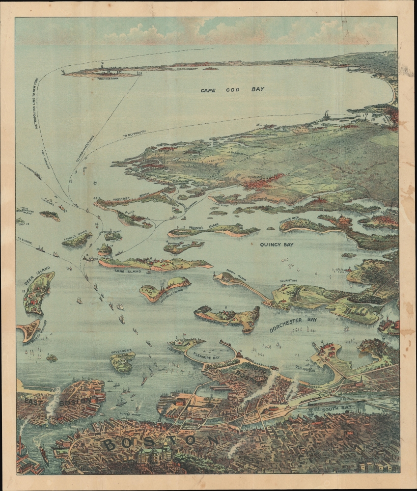
Bird's Eye View of Boston Harbor and South Shore to Provincetown Showing Steamship Routes.
1917 (undated) 19.5 x 16.5 in (49.53 x 41.91 cm)
1917 (undated) 19.5 x 16.5 in (49.53 x 41.91 cm)
Description
This is a c. 1917 chromolithograph map and view of Boston Harbor from Boston to Provincetown published by Union News. In the late 19th and early 20th century, such views were popular travel souvenirs sold at newsstands in train and ferry stations, as well as by newsboys onboard the trains and ferries themselves.
A Closer Look
Coverage embraces Cape Cod Bay, Quincy Bay, and Dorchester Bay, the cities of Boston, Dorchester, Plymouth, and Provincetown, among others. Islands in Boston Harbor are illustrated, including Moon Island, Spectacle Island, Long Island, Governor's Island. Ferry and steamboat routes are illustrated and labeled, with lines to Plymouth, Provincetown, and New York. Smoke rises from Boston's many manufactories. Today, such are construed as pollution and urban defilement, but when this view was printed busy smokestacks were indicative of commercial prosperity and industrial optimism.Chromolithography
Chromolithography is a color lithographic technique developed in the mid-19th century. The process involved using multiple lithographic stones, one for each color, to yield a rich composite effect. Oftentimes, the process would start with a black basecoat upon which subsequent colors were layered. Some chromolithographs used 30 or more separate lithographic stones to achieve the desired effect. Chromolithograph color could also be effectively blended for even more dramatic results. The process became extremely popular in the late 19th and early 20th centuries, when it emerged as the dominant method of color printing. The vivid color chromolithography produced made it exceptionally effective for advertising and propaganda imagery.Publication History and Census
This map was published by the Union Publishing Company of South Station, Boston. An earlier edition was published by John Murphy.Cartographer
Union News Company (fl. c. 1890 - 1969) was founded by William Skelly in the late 1800's and operated until the late 1960s. After the railroads opened it became custom to have boys -newsboys- pass through the cars with waters, newspapers, and other small amenities. Skelly was the first newsboy on the railroad and became well known among railroad passengers. He gradually increased his facilities, hiring additional newsboys, until he virtually monopolized the railroad, and later steamship, news business. He made a small fortune and used this to found the Union News Company. The company was first known for the sales of newspapers in stations until it was able to expand and being selling papers on the train and in station restaurants. Union News continued to grow becoming major distributors of postcards and other printed items through their newsstands at hotels, rail and subway stations. The company officially folded in 1969. More by this mapmaker...
Condition
Very good. Exhibits light wear along original fold lines. Laid down on archival tissue.