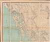
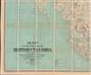
1896 Jörgensen Map of British Columbia, Canada
BritishColumbia-jorgensen-1895-2$3,000.00


Title
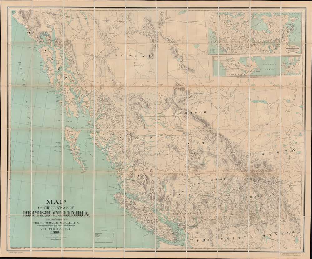
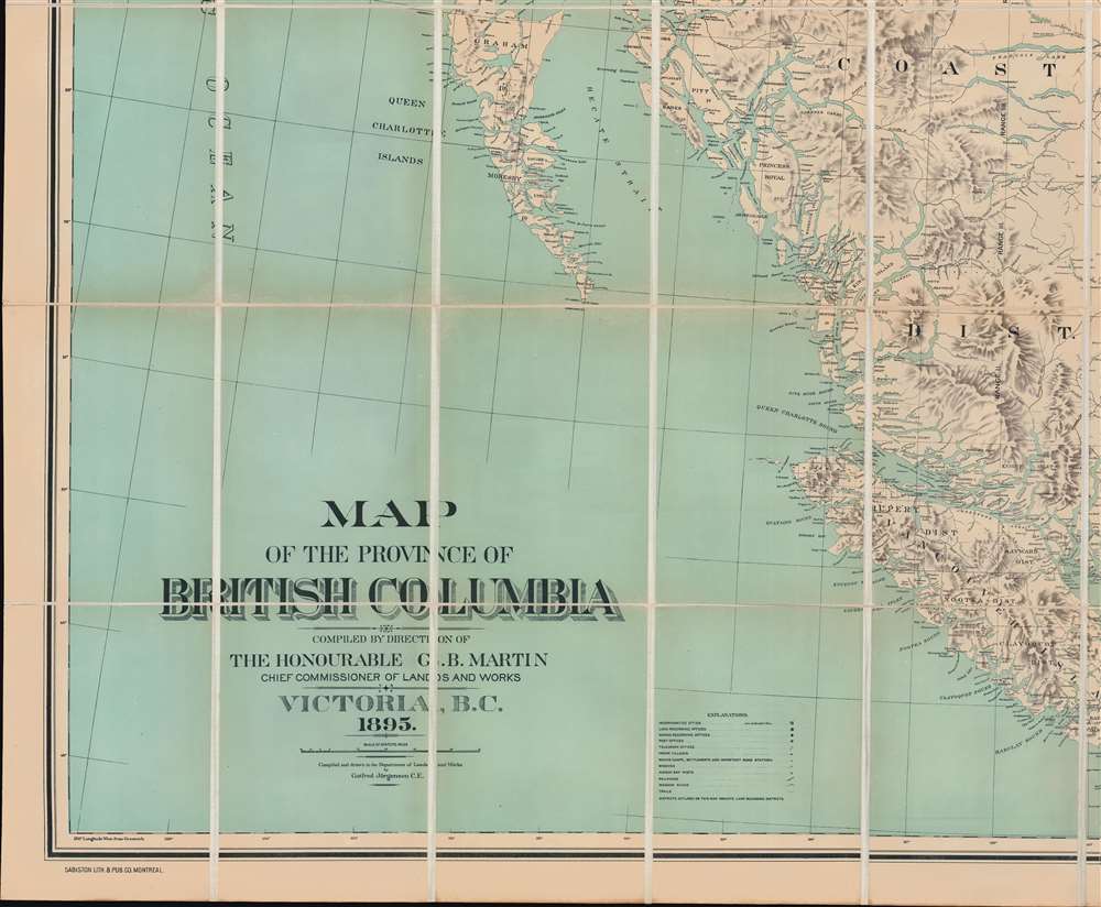
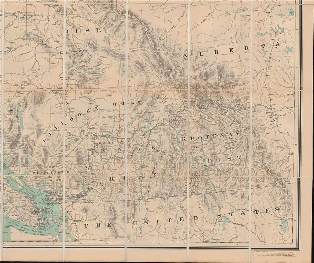
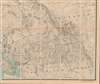
Map of the Province of British Columbia.
1895 (dated) 48.25 x 53.25 in (122.555 x 135.255 cm) 1 : 1300000
1895 (dated) 48.25 x 53.25 in (122.555 x 135.255 cm) 1 : 1300000
Description
This is Gotfred Jörgensen's rare 1895 wall map of British Columbia, the 3rd official map of the province and the best to appear in the 19th century. Jörgensen's map represents a significant advancement over earlier regional maps, offering both greater size and more up-to-date detail. Thomas Kains, Surveyor General of British Columbia, rightly described 'the most perfect map of British Columbia which has thus far been placed before the Public.' The map is significant, emerging as British Columbia, newly connected via railroads and steamship lines, was negotiating its place, both within Canada and globally.
A Closer Look
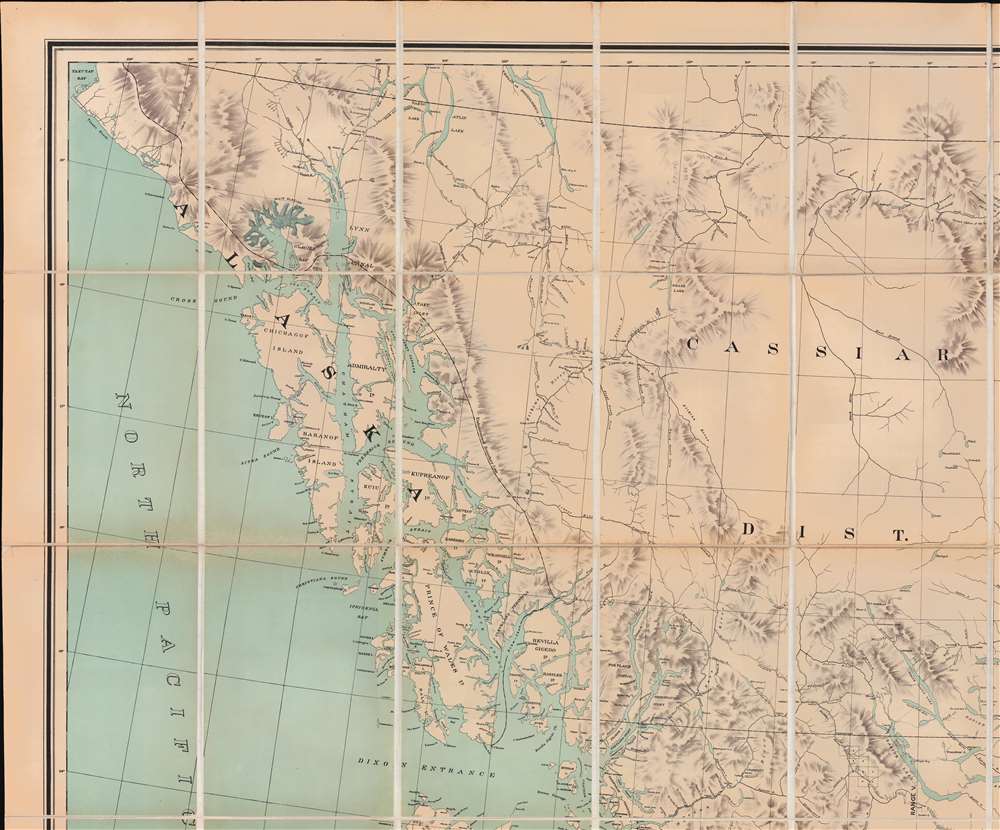
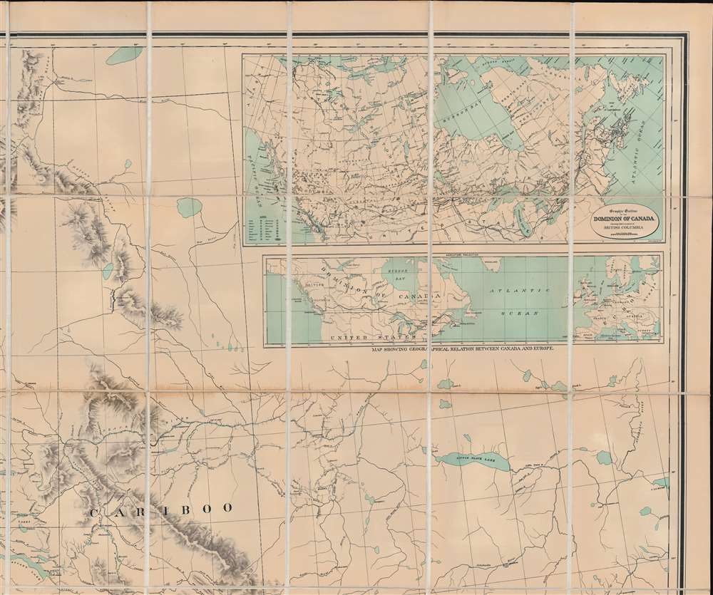
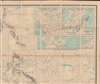
This is an expansive map covering British Columbia as well as the surrounding territory. Coverage extends along the Pacific Seaboard from Yakutat Bay to the Strait of Juan de Fuca and inland to Alberta and Fort Mcleod. A key in the lower left identifies land recording offices, mining offices, post offices, telegraph lines, American Indian villages, mining camps and settlements, missions, Hudson Bay Company posts, railroads, wagon roads, and other trails. Topography is rendered with shading. The map was produced under the aegis of Thomas Kains' (1850 - 1901), who as Surveyor General of British Columbia, redefined regional mapping. Whereas the grid and plat system worked well to map the flat plains to the east, Kains advocated for a more sophisticated trigonometrical survey for the mountainous British Columba. He sponsored first the James Brownlee map (1893) and, as here, the much-improved Jörgensen map. Jörgensen, a Civil Engineer with the Lands and Works Office, compiled the map from existing and newly commissioned surveys, producing a manuscript base map of some 7 x 5.5 feet.A Significant Advance
M. Layland, in his The Land of Heart's Delight: Early Maps and Charts of Vancouver Island, page 132, describes the advances Jörgensen made over the predecessor James Brownlee map (1893),The Map recorded significant advances over its predecessor - Mohun's Map of 1880 and Brownlee's of 1893 - in geographical knowledge of both BC and Vancouver Island. It showed the findings of the reconnaissance explorations of Mohun, Fray, and Gray in the Sayward and Rupert Districts, and Ralph's detail along the western boundary of the E and N grant. As well as the track of the E and N, it showed the line of the newly opened Victoria and Sidney Railway (nicknamed 'The Cordwood Limited'). Some names in the center of Saanich Peninsula - Garnham, Hea, Slugget, Young, Targoose, and Harar - had symbols for post offices, but most are now forgotten. - Layland, M., The land of Heart's Delight: Early Maps and Charts of Vancouver Island, page 132.
Historial Context
This map emerged as British Columbia experienced significant economic and demographic transformation, driven by the expansion of resource industries and the completion of the Canadian Pacific Railway. The railway, finished in 1885, connected the province to eastern Canada and international markets, encouraging migration and settlement, especially in the interior. Gold, coal, timber, and fisheries fueled regional growth, while cities like Vancouver developed into commercial hubs. The Klondike Gold Rush (1896 - 1899), although centered in the Yukon, further stimulated the economy as prospectors passed through British Columbia's ports and outfitting towns. Politically, the province was still negotiating its role within the Canadian Confederation, with debates over Indigenous land rights, immigration (especially concerning Chinese exclusion), and provincial autonomy shaping the decade's social and legislative landscape.Publication History and Census
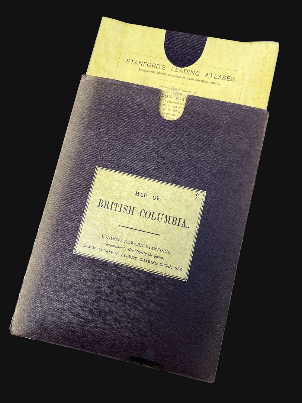
This map was compiled by Gotfred Jörgensen under the direction of George B. Martin, then the Chief Commissioner of Lands and Works for British Columbia. It was printed in three color lithographs by the Sabiston Company of Montreal and published in 1895. The map was issued both as a wall map and, as here, dissected and mounted on linen. The present example bears the pastedown of Stanford's Map Establishment, so it is likely that firm that dissected and mounted it. It is extremely rare. We note just two private sales in the last 30 years. Institutionally, we locate examples in the Bancroft Library, the University of British Columbia, Vancouver Public Library, and the Bibliothèque Nationale de France.CartographerS
Gotfred Emil Jörgensen (fl. c. .1890 - 1910) was a Danish-American civil engineer active in British Columbia, Canada, and Washington State in the late 19th and early 20h centuries. Jörgensen is elusive, and there is no record of his birth in Denmark or his relocation to the Pacific Northwest. He lived for a time in Seattle, where he appears in the 1891 directory as a Civil Engineer, but most of his work was done for the British Columbia Department of Lands and Works. In his earliest maps, he appears as a 'draughtsman', by 1891 he is listed as a 'civil engineer', and by 1909 he is the 'Survey General of British Columbia'. It is possible he returned to Denmark in the early 20th century. He is most admired for his large-scale maps of Victoria City and British Columbia. More by this mapmaker...
Alexander Sabiston (April 1859 - May 5, 1900) was a Montreal based lithographer active in the late 19th century. Sabiston was born in Liverpool, England and spent his early years as a ship's carpenter.. His firm, the Sabistion Lithographic and Publishing Company, was incorporated on 1889. The firm remained active until April 13, 1896, when it went into insolvency. The firm's assets were sold at a public auction on April 28th, 1865, most of which were acquired by one 'George Hyde', who transferred the assets to the managers of the Toronto Lithographing Company. Those gentlemen registered an Appellant Company in Montreal as the 'Montreal Lithographic Company, Ltd'. Meanwhile, in May 1869, Alexander Sabiston and his brother, likely James McLeod Sabiston (1867 - 1948) founded a new firm, the Sabiston Lithographing and Publishing Company. This created a branding conflict with the 'Montreal Lithgoraphic Company', who claimed ownership of the Sabiston name, and filed proceedings against the brothers in December 1896. Learn More...
Edward Stanford (May 27, 1827 - November 3, 1904) was one of the most prolific map publishing firms of the late 19th century. The company began as a partnership in 1848 between the 21 year old Edward Stanford and the established map dealer Trelawney Saunders. By 1853 the partnership had dissolved and Edward Stanford took full control of the business. A subsequent series of expansions and exciting new map issues finally led to the production of Stanford's masterwork, "Stanford's Library Map of London". This map is still available and remains somewhat accurate. At the time of publishing it was hailed by the Royal Geographical Society as "the most perfect map of London that has ever been issued". In 1882 Edward Stanford Sr. passed the firm on to his son, Edward Stanford Jr. who continued in his father's proud tradition. Today the Stanford firm still publishes maps and remains one of the most important and prolific cartographic publishers in the world. Learn More...
Condition
Very good. Some toning on old fold lines. Dissected and laid on linen. Folds into original 'Stanford's Map Establishment' binder. Toning along intermediate folds - typical of most dissected examples.
References
Layland, M., The Land of Heart's Delight: Early Maps and Charts of Vancouver Island, pages 182 - 186.