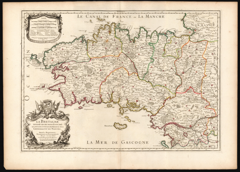
1706 Jaillot Map of Brittany, France
Brittany-jaillot-1706$350.00


Title
La Bretagne Divisée en ses neuf Eveschés qui font aussi l'estendue des Receptes de la Generalité de Nantes.
1706 (dated) 18 x 25.75 in (45.72 x 65.405 cm) 1 : 548000
1706 (dated) 18 x 25.75 in (45.72 x 65.405 cm) 1 : 548000
Description
This is Alexis-Hubert Jaillot's map of Brittany, France, in its 1706 edition. It is among the largest atlas maps of the region, here in a superb example with bright original outline color.
The map identifies the island of Ouessant, the north-westernmost part of France. This western region of Brittany (department of Finistere) is known for its cider production and boar hunting. The Ille-et-Vilaine region, in the northeast of Brittany, is famous for its seafood, especially oysters. The dramatic island and castle of Mont Saint-Michel is depicted just off the coast. The region of Loire-Atlantique, located in the southeast, is part of the Loire Valley wine region and is especially known for producing Muscadet, a white wine made from the Melon de Bourgogne grape variety. This area is also famous for a variety of cow's milk cheese known as Fromage du Cure Nantais. Morbihan is an exceptionally beautiful part of the Breton cost noted for its many islands, many of which are now privately owned by movie stars, politicians, well-known musicians, and other influential people. Morbihan is named for its most unusual feature, a large inland sea near Vannes called The Morbihan. This region is also the home of the mysterious megalithic ruins at Carnac.
A Closer Look
Jaillot's cartography here, as with most of his maps, is drawn from the great 17th-century geographic authority, Nicolas Sanson. The map covers the former province of Brittany from Granville south to Noirmoutier-en-l'lle and from the Celtic Sea inland as far as Craon. The region includes the departments of Finistere, Cotes-d'Amor, Ille-et-Vilaine, Loire-Atlantique (previously known as Loire-Inferieure), and Morbihan. The map renders the entire region in detail, offering topographical and political information with beautifully rendered forests and mountains.The map identifies the island of Ouessant, the north-westernmost part of France. This western region of Brittany (department of Finistere) is known for its cider production and boar hunting. The Ille-et-Vilaine region, in the northeast of Brittany, is famous for its seafood, especially oysters. The dramatic island and castle of Mont Saint-Michel is depicted just off the coast. The region of Loire-Atlantique, located in the southeast, is part of the Loire Valley wine region and is especially known for producing Muscadet, a white wine made from the Melon de Bourgogne grape variety. This area is also famous for a variety of cow's milk cheese known as Fromage du Cure Nantais. Morbihan is an exceptionally beautiful part of the Breton cost noted for its many islands, many of which are now privately owned by movie stars, politicians, well-known musicians, and other influential people. Morbihan is named for its most unusual feature, a large inland sea near Vannes called The Morbihan. This region is also the home of the mysterious megalithic ruins at Carnac.
A Work Of Art
Jaillot, renowned as a map engraver and publisher, was also a sculptor. His artistic background informed the decorative elements of his maps, such as the bold cartouche in the lower left. It is a dedicatory cartouche to the monumentally influential Louis Phélypeaux, Marquis of Phélypeaux and Monsieur de Pontchartrain (1619 - 1714). At the time this map was engraved, in 1693, he was France's Secretary of State and Controller of Finances; by 1706 he left those positions to become Chancellor of France.Publication History and Census
The map was engraved by Robert Cordier in 1693 or 1694 for inclusion in Jaillot's 1695 Atlas François, in which it remained in publication with some changes into the early 18th-century. The map is well represented in institutional collections.CartographerS
Alexis-Hubert Jaillot (c. 1632 - 1712) followed Nicholas Sanson (1600 - 1667) and his descendants in ushering in the great age of French Cartography in the late 17th and 18th century. The publishing center of the cartographic world gradually transitioned from Amsterdam to Paris following the disastrous inferno that destroyed the preeminent Blaeu firm in 1672. Hubert Jaillot was born in Franche-Comte and trained as a sculptor. When he married the daughter of the Enlumineur de la Reine, Nicholas I Berey (1610 - 1665), he found himself positioned to inherit a lucrative map and print publishing firm. When Nicholas Sanson, the premier French cartographer of the day, died, Jaillot negotiated with his heirs, particularly Guillaume Sanson (1633 - 1703), to republish much of Sanson's work. Though not a cartographer himself, Jaillot's access to the Sanson plates enabled him to publish numerous maps and atlases with only slight modifications and updates to the plates. As a sculptor and an artist, Jaillot's maps were particularly admired for their elaborate and meaningful allegorical cartouches and other decorative elements. Jaillot used his allegorical cartouche work to extol the virtues of the Sun King Louis IV, and his military and political triumphs. These earned him the patronage of the French crown who used his maps in the tutoring of the young Dauphin. In 1686, he was awarded the title of Geographe du Roi, bearing with it significant prestige and the yearly stipend of 600 Livres. Jaillot was one of the last French map makers to acquire this title. Louis XV, after taking the throne, replaced the position with the more prestigious and singular title of Premier Geographe du Roi. Jaillot died in Paris in 1712. His most important work was his 1693 Le Neptune Francois. Jalliot was succeeded by his son, Bernard-Jean-Hyacinthe Jaillot (1673 - 1739), grandson, Bernard-Antoine Jaillot (???? – 1749), and the latter's brother-in-law, Jean Baptiste-Michel Renou de Chauvigné-Jaillot (1710 - 1780). More by this mapmaker...
Nicolas Sanson (December 20, 1600 - July 7, 1667) and his descendants were the most influential French cartographers of the 17th century and laid the groundwork for the Golden Age of French Cartography. Sanson was born in Picardy, but his family was of Scottish Descent. He studied with the Jesuit Fathers at Amiens. Sanson started his career as a historian where, it is said, he turned to cartography as a way to illustrate his historical studies. In the course of his research some of his fine maps came to the attention of King Louis XIII who, admiring the quality of his work, appointed Sanson Geographe Ordinaire du Roi. Sanson's duties in this coveted position included advising the king on matters of geography and compiling the royal cartographic archive. In 1644, he partnered with Pierre Mariette, an established print dealer and engraver, whose business savvy and ready capital enabled Sanson to publish an enormous quantity of maps. Sanson's corpus of some three hundred maps initiated the golden age of French mapmaking and he is considered the 'Father of French Cartography.' His work is distinguished as being the first of the 'Positivist Cartographers,' a primarily French school of cartography that valued scientific observation over historical cartographic conventions. The practice result of the is less embellishment of geographical imagery, as was common in the Dutch Golden Age maps of the 16th century, in favor of conventionalized cartographic representational modes. Sanson is most admired for his construction of the magnificent atlas Cartes Generales de Toutes les Parties du Monde. Sanson's maps of North America, Amerique Septentrionale (1650), Le Nouveau Mexique et La Floride (1656), and La Canada ou Nouvelle France (1656) are exceptionally notable for their important contributions to the cartographic perceptions of the New World. Both maps utilize the discoveries of important French missionaries and are among the first published maps to show the Great Lakes in recognizable form. Sanson was also an active proponent of the insular California theory, wherein it was speculated that California was an island rather than a peninsula. After his death, Sanson's maps were frequently republished, without updates, by his sons, Guillaume (1633 - 1703) and Adrien Sanson (1639 - 1718). Even so, Sanson's true cartographic legacy as a 'positivist geographer' was carried on by others, including Alexis-Hubert Jaillot, Guillaume De L'Isle, Gilles Robert de Vaugondy, and Pierre Duval. Learn More...
Source
Jaillot, A-H., Atlas François, (Paris: Jaillot) 1706.
Condition
Excellent. Minor scuffing at bottom centerfold, else fine with generous margins and bright original outline color.
References
OCLC 921698156.