This item has been sold, but you can get on the Waitlist to be notified if another example becomes available, or purchase a digital scan.
1940 Hagstrom City Plan or Map of Brooklyn, New York, and Vicinity
Brooklyn-hagstrom-1940$125.00

Title
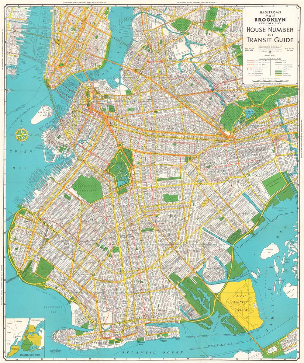
Hagstrom's Map of Brooklyn, New York City House Number and Transit Guide.
1940 (undated) 29.375 x 24.75 in (74.6125 x 62.865 cm) 1 : 24000
1940 (undated) 29.375 x 24.75 in (74.6125 x 62.865 cm) 1 : 24000
Description
This is a c. 1940 Hagstrom map of Brooklyn, New York, and the immediate vicinity. Every street in Brooklyn is labeled, as are the streets in Manhattan up to East 25th Street and part of Queens. Subway lines are illustrated in red, with different symbols used to differentiate between the IRT West Side, the IRT East Side, the BMT, and the IND. Surface streetcar lines are also marked by thin red lines, while elevated subway lines are illustrated by solid black lines. The Long Island Railroad is also illustrated. Parks are colored green, along with cemeteries, which are identified by small crosses. Prospect Park and the Botanic Gardens are depicted in some detail, with both the Central Library and the Brooklyn Museum illustrated and labeled, along with Grand Army Plaza.
Dating This Map
When dating this map, we used several different references to help narrow down a range. Two important mentions that place this map firmly in the 1930s is the presence of the U.S. Coast Guard on Floyd Bennet Field and the fact that Spring Creek Park is referred to as simply having been proposed. Spring Creek Park was not approved until 1942, even though it was proposed as early as 1930. The presence of the Queens-Midtown Tunnel allows for a smaller date range, since it didn't receive the green light until May 1935 and construction didn't begin until October 1936. The tunnel opened on November 15, 1940, making a c. 1940 date our best assessment.Publication History
This map was created and published by the Hagstrom Company c. 1940.Cartographer
Andrew Gunnar Hagstrom (1890 - September 24, 1977) was a map publisher based in Maspeth, Queens. Hagstrom was a Swedish immigrant who came to new York in 1909 where took work milking cows at a farm near Coney Island, Brooklyn. He then worked in the meat packing industry while taking a degree in commercial art at the New York Mechanics Institute. Afterwords he founded a drafting business in Manhattan, creating a map to illustrate his drafting skill help customers locate his shop. His map proved popular and he expanded operations, founding the Hagstrom Map Company (1916 - 1968) and issuing additional maps of various parts of New York City and the surrounding regions. By 1949, Hagstrom had issued more than 150 maps, guides, and atlases, most of which focused on New York. Hagstrom pioneered a cartographic style that exaggerated street size to increase clarity and create additional room for large print readable labeling. Even the New York Subway system hired Hagstrom to produce its map, which was in use from the 1940s to 1958. Hagstrom died in 1977, at the age of 81. Hagstrom was knighted by the King of Sweden. His company flourished until 1968 when it was acquired by Macmillan. The brand has since passed through multiple corporate portfolios and is currently the property by Kappa Publishing Group. More by this mapmaker...
Condition
Very good. Light wear along original fold lines. Blank on verso. Attached to back of original binder.